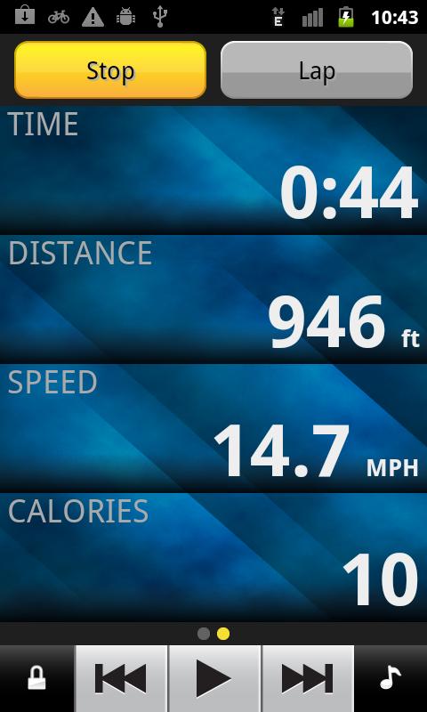
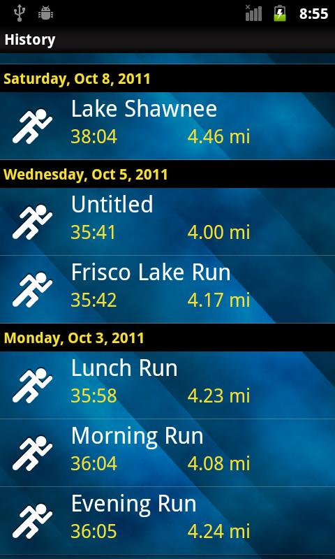
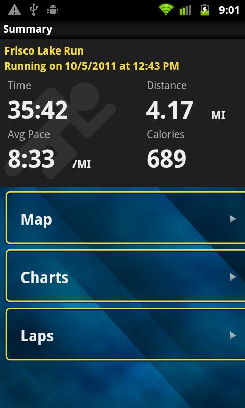
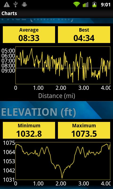
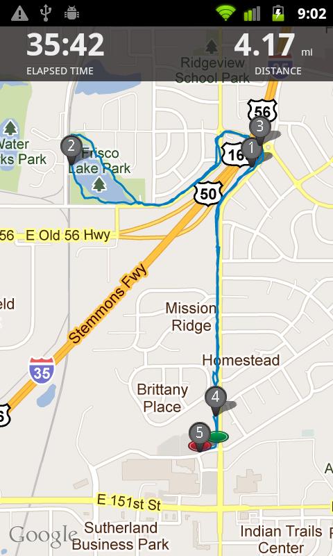
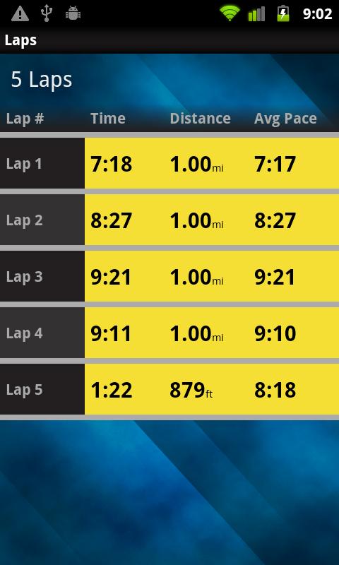
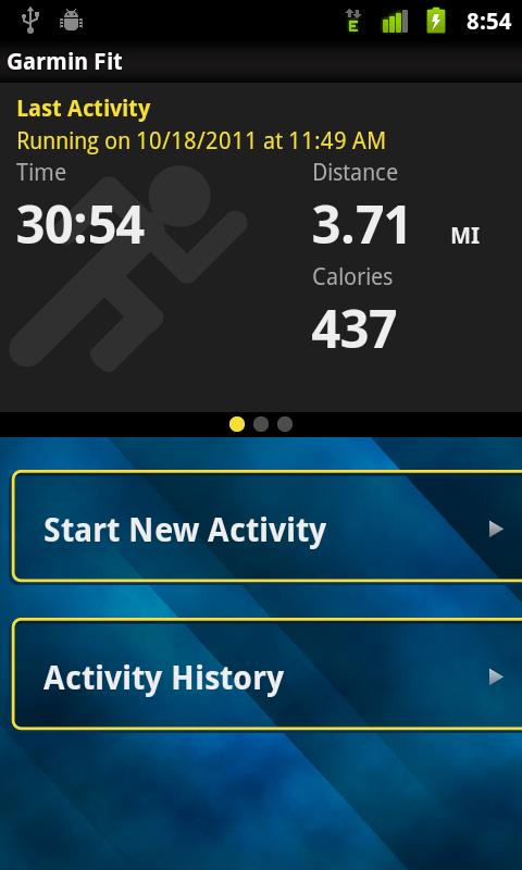
Garmin Fit for Android - Garmin Fit allows you to use your Android smartphone as a fitness assistant for tracking your outdoor activities. Whether you are cycling, running or simply walking, the app will show you useful information like speed, distance, route and calories burned. If your smartphone is ANT+ enabled, you will receive additional data, depending on the sensors of your device, such as heart rate or cadence.
In addition, by purchasing a monthly or yearly subscription from within the app, you will unlock the LiveTrack functionality. This feature allows friends you have invited vie email, Facebook or Twitter to track your fitness activities in real-time.
What's New in This Release:
· Various bug fixes.
Like it? Share with your friends!
Supported operating systems:
Google Android 10.x, Google Android 2.1, Google Android 2.2, Google Android 2.3, Google Android 3.0, Google Android 3.1, Google Android 3.2, Google Android 4.0, Google Android 4.1, Google Android 4.2, Google Android 4.3, Google Android 4.4, Google Android 5.x, Google Android 6.x, Google Android 7.x, Google Android 8.x, Google Android 9.x
Other Software by developer «Garmin»:
Garmin China Garmin China - Garmin StreetPilot is a powerful GPS navigation solution for iOS devices. It comes preloaded with the latest maps of China, Hong Kong and Macau.
Garmin Street offers many useful features, such as turn-by-turn directions, photo-realistic junction views, 3D buildings, exit services, speed cameras, and more
Garmin GTN Trainer Garmin GTN Trainer - The Garmin GTN 750 Trainer allows you to experience the pilot interface and provide an on-the-ground environment to learn the basic operation of the avionics
Garmin viago for Android Garmin viago for Android - Garmin viago turns your Android smartphone or tablet into a fully featured personal GPS navigator. The app can safely guide you to your destination with clear turn-by-turn directions, lane assistance to help you navigate complex junctions and speed limit indicators to help you avoid getting speeding tickets
Garmin GTN Trainer Garmin GTN Trainer - The Garmin GTN 750 Trainer allows you to experience the pilot interface and provide an on-the-ground environment to learn the basic operation of the avionics
Garmin Taiwan Garmin Taiwan - Garmin StreetPilot is a powerful GPS navigation solution for iOS devices. It comes preloaded with the latest map of Taiwan, including over 250,000 points of interest.
Garmin Street offers many useful features, such as turn-by-turn directions, photo-realistic junction views, 3D buildings, exit services, speed cameras, and more
Garmin GDL 39 Utility Garmin GDL 39 Utility - Garmin GDL 39 Utility is a companion app for the GDL 39 Portable ADS-B Receiver. It allows you to update your GDL 39 firmware using your iOS device.
The application also shows the signal strength, ground station status and battery life of GDL 39. In addition, it includes a navigation panel, which displays altimeter, heading and ground speed
Whereis Navigator Whereis Navigator turns your Telstra Android device into an easy to use & full-featured GPS navigation unit, powered by Garmin and available for use in Australia only
Garmin U.S.A. Garmin U.S.A. - Download Garmin StreetPilot Onboard U.S.A. and give your iPhone the best in GPS navigation...even when you don’t have cell coverage. Maps reside on your device, so you can look up addresses and millions of points-of-interest such as gas stations, restaurants and ATMs without needing wireless coverage
Garmin Tracker (Android) Garmin Tracker (Android) - Brought to you by the worldwide leader in GPS, Garmin Tracker — combined with a GPS-enabled Garmin tracking device (purchase required) — lets you track what’s important while on the go.
Garmin Tracker is a free, unique application that will help keep tabs on whatever is important to you
Garmin SG/MY Garmin SG/MY - Garmin StreetPilot is a powerful GPS navigation solution for iOS devices. It comes preloaded with the latest maps of Singapore, Malaysia and Brunei.
Garmin Street offers many useful features, such as turn-by-turn directions, photo-realistic junction views, 3D buildings, exit services, speed cameras, and more