Platforms: iPhone, iPad, iPod Touch, Apple iPhone OS
Categories: Travel & Navigation
Upload date: 29 Oct 11
Developer: Visual IT
License: Commercial
Price: 9.99 $
Downloads: 25
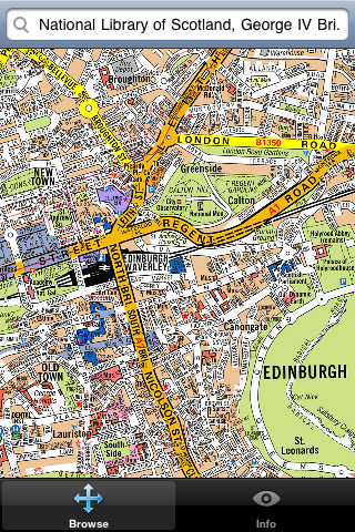
Edinburgh Mini A-Z - This street map of Edinburgh covers an area extending to Cramond, Granton, Leith, Portobello, Musselburgh, Whitecraig, Dalkeith, Bonnyrigg (part), Loanhead, Fairmilehead, Juniper Green, Currie, Balerno, and Edinburgh Airport.
Major buildings are colour-coded to indicate places of interest and other buildings that are open to the public.
Also included is a listing of hospitals, hospices, and NHS Walk-in Centres that are within this area.
The index section of the atlas lists: streets, walkways, places of interest, selected flats, place and area names plus National Rail and Metrolink stations.
This map is drawn by real cartographers with the detailed care and human touch of emphasis and colour that A-Z are famous for. Internet maps are OK but you really can’t beat the genuine article.
With this map installed on your device there is never any need for an internet connection enabling you to access the map anywhere and at anytime. This application starts up in under 5 seconds and can find any location on the map in under 2 seconds. You can also use your inbuilt location services (GPS, Wifi, etc) to locate your position on the map.
Visual IT have partnered with the “Geographers A-Z Map Company” and negotiated a license to produce this map for iPhone or iPod Touch users at this very competitive price.
What's New in This Release:
· Support for retina display
· New "Measure Tool"
· Bug fix for the next iOS release
Like it? Share with your friends!
If you got an error while installing Themes, Software or Games, please, read FAQ.
Supported operating systems:
Apple iOS 10.x (iPad), Apple iOS 10.x (iPhone), Apple iOS 11.x (iPad), Apple iOS 12.x (iPad), Apple iOS 12.x (iPhone), Apple iOS 4.0.x (iPhone), Apple iOS 4.0.x (iPod Touch), Apple iOS 4.2.x (iPad), Apple iOS 4.2.x (iPhone), Apple iOS 4.2.x (iPod Touch), Apple iOS 4.3.x (iPad), Apple iOS 4.3.x (iPhone), Apple iOS 4.3.x (iPod Touch), Apple iOS 5.0 (iPad), Apple iOS 5.0 (iPhone), Apple iOS 5.0 (iPod Touch), Apple iOS 6.0 (iPad), Apple iOS 6.0 (iPhone), Apple iOS 6.0 (iPod Touch), Apple iOS 7.0 (iPad), Apple iOS 7.0 (iPhone), Apple iOS 7.0 (iPod Touch), Apple iOS 8.x (iPad), Apple iOS 8.x (iPhone), Apple iOS 8.x (iPod Touch), Apple iOS 9.x (iPad), Apple iOS 9.x (iPhone), Apple iOS 9.x (iPod Touch), Apple iPhone OS 3.1.x, Apple iPhone OS 3.1.x (iPod Touch), Apple iPhone OS 3.2.x (iPad)
Other Software by developer «Visual IT»:
London Central Bus 10 for iPad London Central Bus 10 for iPad - The new Zuti London Bus map has finally arrived, making it easy to travel by bus anywhere in central London. This clear and colourful map covers a detailed street level area of 6 miles by 4 miles and includes over 1300 bus stops and 189 bus routes
Tube 2 Miami (Palm OS) Tube 2 Miami (Palm OS) - This map package for Tube 2 consists of a fully scrollable detailed map of the Miami metro & rail system.
Plan journeys on this system, list details of the quickest routes and see a superb animated display of your journey tracking around the system map
London Visitors A-Z for iPad London Visitors A-Z for iPad - The London Visitors A-Z map of central London is designed especially for the tourist
Barcelona Metro 10 for iPad Barcelona Metro 10 - This Zuti application contains a visually unique map of the Barcelona transport system and a superb animated journey planner to help you get around the TMB (Transports Metropolitan de Barcelona), FGC (Ferrocarrils de la Generalitat de Catalunya) Metro and Tram services
London Mini A-Z for iPad London Mini A-Z for iPad - This clear and colourful high quality map is a digital rendition of the famous "London A-Z Mini Atlas" and covers an area from West Hendon in the North West to Grove Park in the South East. Add this application to you iPad and you will have instant access to all 352 pages of the London Mini A-Z printed map
Tube 2 Dublin (UIQ) Tube 2 Dublin (UIQ) - This map package for Tube 2 consists of a fully scrollable detailed map of the Dublin rail system.
Plan journeys on this system, list details of the quickest routes and see a superb animated display of your journey tracking around the system map
Tube 2 Boston Pro (UIQ) Tube 2 Boston Pro (UIQ) - This map package for Tube 2 consists of a fully scrollable detailed map of the Boston metro & commuter rail system and linked street maps of central Boston.
Plan journeys on the metro system, list details of the quickest routes and see a superb animated display of your journey tracking around the system map
Tube 2 New York Geo (UIQ) Tube 2 New York Geo (UIQ) - This superb map package for Tube 2 is the ideal map for anyone who needs to get around New York City using the MTA subway system and would like to know just exactly where they are.
The map geographically accurately locates all of Manhattans central stations, overlaid onto a street map
Beijing Subway by Zuti Beijing Subway by Zuti - The new Beijing Metro 10 map makes it easy to travel in and around the city using the Metro, Batong line, Airport Express line and Suburban S2 lines services
London Underground for iPad by Zuti London Underground 10 is a superb map and route planner for the London Underground, Overground and Docklands Light Railway (DLR) services. So you can make a quick exit when you leave the train we have now added exit information for all stations on the London Underground


")


")
")
")

