mdNavMobile is a waypoint-based GPS navigation solution for the Windows Mobile platform. It can guide you from waypoint to waypoint while keeping you informed of all relevant navigation data. All NMEA-data from a GPS is automatically logged to file so you can 'replay' a trip with variable speed.
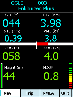
· GPS info: Latitude, Longitude, COG, SOG, Height, Satellites, HDOP and NMEA-stream
· Waypoint info: CTS, DTG, TTG, VMG, XTE
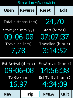
· Trip info: Total distance, Start, Travelled distance/time, DTG, TTG, ETA
· Reverse and Reset trips
· Scroll to next/previous waypoint
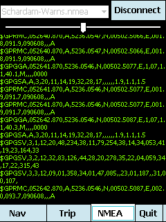
· Logs full NMEA stream from GPS to Storage Card
· Simulation using NMEA-log files with variable speed (factor 0.01-100)
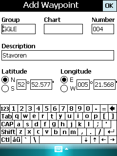
· Create/Edit Trips and Waypoints
· Show data in nm/kts/ft or km/kmh/m
· Change colors
· Trip-files also editable with notepad
· Totally free
Like it? Share with your friends!
If you got an error while installing Themes, Software or Games, please, read FAQ.
Supported operating systems:
Windows Mobile 5.0, Windows Mobile 6 Classic, Windows Mobile 6 Professional, Windows Mobile 6.1 Classic, Windows Mobile 6.1 Professional, Windows Mobile 6.5 Professional
Similar Software:
amAze (Windows Mobile) AmAze is a first of its kind free navigation and local search service. It is free to download and use and it contains wide coverage of maps including aerial photo in Europe, North America, Australia and parts of Asia and Africa
RulerZIPeds RulerZIPeds allows you to enter 2 American ZIP codes and converts the ZIP codes into GPS coordinates. The program then calculates the distance between the points. You can also download a Google.com map of the route. This service is provided by USZIP
Kai's GPS Tracker.Net With the GPS Tracker you send your Position via 'SMS' or 'SMS to e-mail' to another person and tell him/her so your location. The recipient gets a SMS or e-mail with the location and a link to a map (on PC). Use it for your friends, family or in a company. Also suited to send holiday greetings from a foreign country
NoniGPSPlot Pocket PC NoniGPSPlot allows you to locate your position in relation with other GPS points, to see the journey you have traveled.
You can find back your place at harbour after a trip on boat, the starting point of an excursion or locate your car in a huge car park, A place of which you know the location, To see the excursion you made, Speed trap alert or lots of other things..
GPSmeter Do you still use your GPS device for navigating only?
Turn your Pocket PC into a high precision metering machine using your GPS receiver! With MASPware GPSmeter you can measure short and long distances (beeline or routelength), altitude differences, timespans, average values and min-max-values using an internal or external GPS receiver
RadarGPS Making of radars database and dangerous objects
TwitterGPSerer TwitterGPSerer allows you to oAuth update and view Twitter contacts via GPS. You can use the GPS to find your current location and send a tweet and also track your friends via Twitter. The map service is provided by Google.com. The tweet service is provided by Twitter
VITO ActiveTrace VITO ActiveTrace is a sports oriented software specially designed to help you watch your sports progress. VITO ActiveTrace turns a Smartphone into your personal coach that accurately keeps detailed statistics for every trip and also records corresponding tracks. Just turn VITO ActiveTrace on, put your device in a pocket and concentrate on training
FON Access Points for Malta FON Access Points for Malta - FON offers you a new Points of Interest service (POIs). This allows you to download FONspots directly to your navigation device.
What does that mean? You can download a Points of Interest file directly to your navigation device
gOmniTracker Wonder where was your teenager spending time last night? or when did they leave school, home, or tennis-practice? Or maybe it's granny you're concerned about whether she got back home from the park yet
Other Software by developer «Maurits Dijkens»:
not found
Comments on mdNavMobile:
Comments not found
If you noted an error or download link is broken, please, report it via this page or use comments.
mdNavMobile is compatible with your device Dopod Touch Diamond S900 (HTC Diamond 100)

")


")


