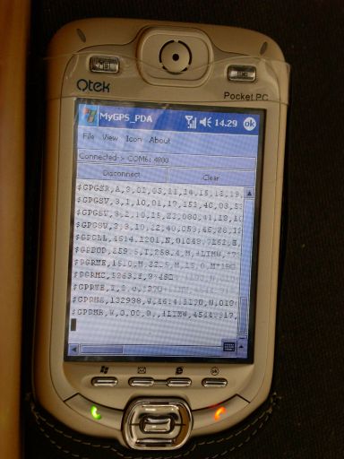
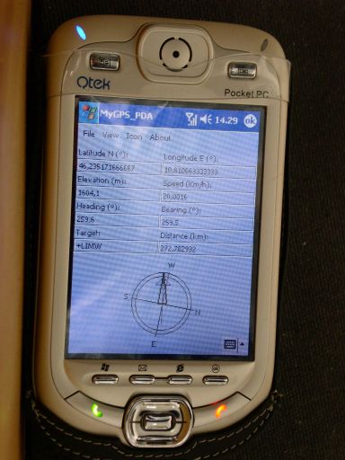
MyGPS_PDA - MyGPS_PDA is a light MyGPS version for PocketPC systems. It reads the NMEA sentences coming from a GPS antenna connected to the PocketPC and shows your position on a MyGPS calibrated map. The program can also store on a file the track log together with specific waypoints created by the user.
Like it? Share with your friends!
If you got an error while installing Themes, Software or Games, please, read FAQ.
Supported operating systems:
Windows Mobile 2003, Windows Mobile 5.0, Windows Mobile 6 Classic, Windows Mobile 6 Professional, Windows Mobile 6.1 Classic, Windows Mobile 6.1 Professional, Windows Mobile 6.5 Professional
Similar Software:
JVTrip JVTrip - Track yourself while you are on a trip, walking, cycling, driving or just watch your child move. And then export the path to Google Earth.
You can add notes, costs or pictures to your path. This information will be stored with the GPS location where you added them. When you export your track to Google Earth, all information will be there as markers
GPSLoggerer GPSLoggerer logs and displays the data that comes from your GPS unit in your device in NMEA sentences. You can select the output to a NMEA extension or or text file extension. When you select save all logs after the save will be saved to the file. When you select close the logging will stop
PictureGPSeds PictureGPSeds - PictureGPSeds is a full-featured picture/video GPS tagger. When a new picture/video is detected in the camera folder the current GPS is appended to the end of the file. You can browse the files via GPS and map them. You can also send them via email.
This program requires that you have both the 'BeanDLL
CityGoogler CityGoogler uses the GPS on your PocketPC to find the 50 closest local business from 2,238 type of Yellow Pages entry sorted via GPS distance and stores the results into files based on store type. Tap the button to start the GPS and when you get a lock tap on it to view the list of local businesses. The GPS maps and business search service is provided by Google
Pocket PC Geocaching Tools Pocket PC Geocaching Tools - Many tools in one program to help you while you are geocaching.
What's included?
* Open GSAK databases directly
* HTML view
* Field Notes
* Hint decoder and decryption
* Several coordinate functions
* Solver
* Transformer (Text to Digits, etc
Navigation BE-ON-ROAD Europe Q2/2011 Navigation BE-ON-ROAD Europe Q2/2011 - The new major version of be-on-road presents new features and is based on new platform which brings high level of reliability, portability and speed on almost any kind of device. The new be-on-road brings high value voice guided door-to-door navigation
ExerciseGPSs ExerciseGPSs - ExerciseGPSs uses the GPS on your PocketPC to view on a large display your walking/running/riding speed on a moving graph. You can use this to keep your exercise pace. NOTE: The program does not display/graph 0 speeds.
This program requires that you have both the 'BeanDLL.dll' file ** and ** the runtime files for Visual Basic on your PocketPC computer
FileGPSed FileGPSed - FileGPSed allows browse and view GPS tagged Excel, Word, Note, Voice, Text and Picture/Video files. You can browse the folders of the PocketPC for GPS tagged files and view them via GPS distance from your current location. Tap on the file to open it in the associated application.
This program requires that you have both the 'BeanDLL
TextGPSed TextGPSed - TextGPSed can be used to make text files with a GPS tag as the text file name. Each time you make a file the file is named the latitude and longitude of the file. You can store your files on the storage card. You can also view the text files with Google maps.
This program requires that you have both the 'BeanDLL
ActiveStealth Safety Camera Alert software ActiveStealth Safety Camera Alert software - If you have ever found yourself thinking ?I don't remember driving that last stretch of road,? then Cheetah's brand-new driver safety software could be just the product to help your PDA or Pocket PC Phone keep you safe and ticket-free on the road
Other Software by developer «Paolo Faure Ragani, Pier Paolo Colombo»:
not found
Comments on MyGPS_PDA:
Comments not found
If you noted an error or download link is broken, please, report it via this page or use comments.
MyGPS_PDA is compatible with your device Dopod E806c (HTC Wave)

")