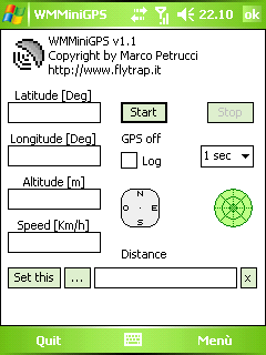
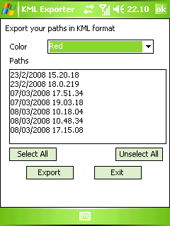
WMMiniGPSis a Windows Mobile 5/6 software which gets your GPS data in a really simple gui, showing you latitude, longitude, altitude and speed. It can log all to file and it can export your paths to Google Earth's kml and gpx format.
There's a compass, which shows your direction and you can set latitude and longitude of a point and the program will show you the way to reach it with a radar, telling you how many meters / kilometers there are to cover.
What's New in This Release:
· fixed export dialog box problem
Like it? Share with your friends!
If you got an error while installing Themes, Software or Games, please, read FAQ.
Supported operating systems:
Windows Mobile 5.0, Windows Mobile 6 Classic, Windows Mobile 6 Professional, Windows Mobile 6.1 Classic
Similar Software:
PoliceGoogler PoliceGoogler uses the GPS on your PocketPC to find the 50 closest police services sorted via GPS distance. Tap the button to start the GPS and when you get a lock tap on it to view the list of local police services. You can also dial the numbers. The GPS maps and pig search service is provided by Google
Phonetracker Locator Phonetracker Locator -transforms a Windows Mobile 5.0 / WM6 PPC Phone with built in GPS receiver or external Bluetooth GPS receiver into a GPS/GSM tracking device.
Received SMS are checked for location statements by Phonetracker4Free and transferred to Google Maps Mobile independently
TrackyPro (online GoogleMaps with GPS) TrackyPro - If you have taken your auto navigation system into the woods you probably realized that it becomes more of a paper weight than a navigation device. Without roads most cannot function. That is why you may need off-road navigation software
NaviComputer NaviComputer is a GPS maps and offroad navigation/tracking software designed for Windows Mobile devices.
What makes NaviComputer outstanding is the ability to view maps offline - without need for internet connection or dataplan
FON Access Points for Jersey FON Access Points for Jersey - FON offers you a new Points of Interest service (POIs). This allows you to download FONspots directly to your navigation device.
What does that mean? You can download a Points of Interest file directly to your navigation device
waze Waze - Waze is a free, 100% user-generated, social navigation application that allows drivers to build and use live maps & real-time traffic updates to improve their daily commute
TrackMe TrackMe - Tool that stores GPS positions and uses that information to generate KML files that can be used by Google Earth or Google Maps for displaying realtime or prerecorded tracks.
The data can be stored locally on your PDA or remotely on a server. You can use my server (free of charge) for storing your data
GpsSpot GpsSpot
You don't know where you parked your car anymore? Have you ever wondered how far your are away from home and in what direction it is? GpsSpot from Cradle Software shows you in what direction and how far a previously saved spot is
GridHIKER GridHIKER-software for handheld units. A step further than raw numeric coordinates.
Recommended for paper map enthusiasts requiring determining his position. GridHIKER shows position graphically on usual Geographic grid or UTM grid which should be drown on paper map.
Features:
- Displaying Geographical grid for position between Lattitude -80S and 84N
Other Software by developer «Marco Petrucci»:
not found
Comments on WMMiniGPS:
Comments not found
If you noted an error or download link is broken, please, report it via this page or use comments.
WMMiniGPS is compatible with your device Dopod CHT 9110


")


