GPS data pusher, the current geographic position can be send in a special SMS message
Navigation with turn by turn route guidance in 3D view, cost advantage - don''t need internet connection, don''t need a map
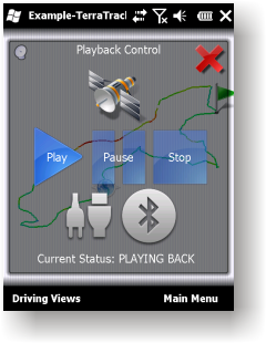
GPS simulator, playing back of recorded tracks
Route guidance in 3D view, makes navigation processes very simple and intuitive.
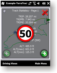
Recorded Track: Statistical analysis of track point information.
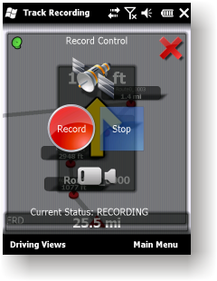
Track recording. Full NMEA-0183 format compatibility.
Playing back to your desktop PC''s NMEA-0183 Navigation software (Microsoft Streets and Trips 2010, Google Earth and many others). Virtual Serial Port (COM port) Driver for playing back at the same Windows phone.
Like it? Share with your friends!
If you got an error while installing Themes, Software or Games, please, read FAQ.
Supported operating systems:
Windows Mobile 2003, Windows Mobile 5.0, Windows Mobile 6 Classic, Windows Mobile 6 Professional, Windows Mobile 6.1 Classic, Windows Mobile 6.1 Professional, Windows Mobile 6.5 Professional
Similar Software:
Virtual Earth Mobile Virtual Earth Mobile (VEM) is an application that displays maps and satellite photography
Travel Beijing, China. Illustrated Guide, Phrasebook and Maps. Travel Beijing, China. Illustrated Guide, Phrasebook and Maps. - An illustrated city guide, phrasebook, and maps. Indulge Yourself with a personal tour guide on Your PDA. FREE General chapter, basic phrasebook, and a map in the trial version.
Features
Fully illustrated.
Historical overviews.
Interesting facts
Map of North Carolina (US State) Map of North Carolina (US State) - A map of the North Carolina by VITO Technology. Good for intercity travels with SmartMap.
SmartMap is a mobile device application which uses vector and raster maps. It is compatible with any NMEA protocol GPS receiver (Compact Flash socket, serial port, BlueTooth or sleeve)
Travel New York City - illustrated guide and maps. FREE general info and a map in the trial version. Travel New York City - illustrated guide and maps. FREE general info and a map in the trial version. - An illustrated city guide and maps. Indulge Yourself with a personal tour guide on Your PDA. FREE General Information chapter and a map in the trial version.
Features
Fully illustrated.
Landmarks map, Street maps, Subway map, and more
MyGPS PDA MyGPS_PDA - a light version of MyGPS software for Pocket PC systems. It reads the NMEA sentences coming from a GPS device connected to the Pocket PC and shows your position on a calibrated map. A calibrated map can be generated using MyGPS for PC and starting from any raster image file (.bmp, .jpg, .gif). MyGPS_PDA requires the Ewe VM installed on the Pocket PC
Map of Utah (US State) Map of Utah (US State) - A map of the Utah by VITO Technology. Good for intercity travels with SmartMap.
SmartMap is a mobile device application which uses vector and raster maps. It is compatible with any NMEA protocol GPS receiver (Compact Flash socket, serial port, BlueTooth or sleeve)
Rough Guides Map Washington DC Rough Guides Map Washington DC... These guides are a series of fantastic interactive maps.
Produced in conjunction with the premier travel publisher Rough Guides.
Discover and explore Washington DC using full colour interactive linked maps, in this simple to use PDA version of The Rough Guides Washington DC
Map of South Africa Map of South Africa - A map of South Africa, divided into 9 smaller territories for the ease of use.
NORTHERN
NORTH WEST
GAUTENG
MPUMALANGA
FREE STATE
KWAZULU-NATAL
EASTERN CAPE
NORTHERN CAPE
WESTERN CAPE
Good for intercity travels with SmartMap
Comments on TerraTrack Recorder 7:
Comments not found
If you noted an error or download link is broken, please, report it via this page or use comments.
TerraTrack Recorder 7 is compatible with your device Dopod 828


")


")

![USA-OH [Ohio] Map for EagleEye PDA Tracking System](https://static.mobyware.org/data/images/def_program_reduced.png "USA-OH [Ohio] Map for EagleEye PDA Tracking System")
