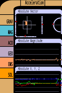
Tricorder - A simple tricorder simulator for Android powered phones, using real sensors to detect magnetic fields, gravity, etc. See the passing gravity wave from a distant collapsar on your phone screen (actual device sensitivity may be insufficient to detect gravity waves). Detect buried powerful magnets! Be a mega-geek! Etc. How to Use Use the buttons on the left to select the mode: * GRA: monitor the local gravitational field and acceleration
* MAG: monitor the local magnetic field
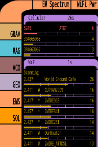
* ENV: monitor environmental parameters including light level, object proximity and temperature
* GEO: display geographical information
The two field displays show the corresponding field information as a 3-D plot with X and Y on a cross-axis plot, with the Z value shown beside it. The elevation of the field above or below the X-Y plane is shown on a separate indicator. The absolute magnitude of the field value is plotted below, and the numeric data is shown below that. · Tricorder displays gravitation and magnetic field, environmental and geographic information, based on information from the sensors in the device.
· Accuracy is limited to what the sensors can provide.
What's New in This Release:
· Fixed some crashes and the visible and magnetic Sun images.
What's New in 5.11:
· Fixed GEO compass orientation in landscape mode.
Like it? Share with your friends!
Supported operating systems:
Google Android 1.6, Google Android 10.x, Google Android 2.0, Google Android 2.1, Google Android 2.2, Google Android 2.3, Google Android 3.0, Google Android 3.1, Google Android 3.2, Google Android 4.0, Google Android 4.1, Google Android 4.2, Google Android 4.3, Google Android 4.4, Google Android 5.x, Google Android 6.x, Google Android 7.x, Google Android 8.x, Google Android 9.x
Similar Software:
Maverick Off-road GPS navigator with offline maps support, compass and track recording. Use offline maps and GPS even without an internet connection. This app is great for hiking, boating, geocaching and other outdoor activities
VGPS (Vietnamese GPS) for Android VGPS was designed to use city street map on your ordinary mobile phone without the need of having GPS receiver or internet connection. VGPS does not require internal or external GPS receiver. However, if you have internal GPS receiver or external bluetooth GPS receiver, VGPS can work with your GPS receiver as well
Send My Position Send My Position is an application which shows your current location using GPS and allows you to send the coordinates using SMS as Google Maps links.
· Shows your current location using GPS
· Allows you to send your location coordinates to anyone using SMS
· Google Maps link send using SMS (Android, iPhone..
ParkLeitSystem ParkLeitSystem is a car-park-routing system. It shows you, according to your GPS position, the nearest city with a car-park-routing system and gives you a list with all available car-parkings and shows how many free places there are. With a click on the parking it switches to google maps and shows you the position of the parking
2GIS 2 gis - is a useful mobile navigator which allows you to use maps in offline mode after you download data of a certain city. The application will easily help you find the needed address, telephone and working time of organizations and will offer several options regarding the best route
Locate My Family Locate My Family - Why do you need Locate My Family application?
1. Locate My Family tracks, monitors and manages an individual or group of people for operational and safety security reasons.
How to start?
1. Install the application on your Android phone.
2. Create your account by providing your email id, phone number of the device, name, country and submit it.
3
BlueGPS4Droid BlueGPS4Droid is an application for using an external Bluetooth GPS on Android devices.
The application starts a service, then connects to a Bluetooth device (NMEA GPS) and creates a mock GPS provider which can be used to replace the internal GPS.
It's also possible to log the external GPS NMEA data in a file on the device
Android Photo GeoTag Android Photo GeoTag - Take pictures with your mobile phone and incorporate the data of the geographical location. The application allows you to include in the photographs, data from the GPS receiver, along with a brief note. If you know the coordinates, not having the GPS receiver, you can also handwrite geographic data
GPS Assistant GPS Assistant - GPS Assistant is a simple and intuitive app which shows location data from the GPS receiver. You can check your coordinates (latitude and longitude) and altitude. Additionally, it includes a speedometer.
What's New in This Release:
· Changed ad network
What's New in 1
GPS Map Camera use GoogleMap GPS Map Camera use GoogleMap - The main feature of the 'GPS Map Camera':
When you take a piture with GPS enabled, it will paste the google map, address and weather to picture. (GPS latitue/longitude also include in the information)
Please enable your network and GPS function before using this application
Other Software by developer «Moonblink»:
Test Card Test Card - A very simple screen test card for Android. Designed to allow you to view the structures of pixels under magnification. On many phones this will be totally uninteresting; on some, notably AMOLED displays, it may be more useful. Please read the help for more info
Substrate Substrate - This application contains a collection of live wallpapers for Android. Once installed, you can install any of the wallpapers on your desktop in the usual way. The package also contains a runnable application which previews all the wallpapers and provides access to their settings
TouchTest TouchTest is a simple Android application to test screen parameters and multi-touch.
The application displays a 50-pixel grid which illustrates the screen sizes, and edge markers to check the registration of the screen edge with the surrounding bezel
TiltLander TiltLander is a simple project to demonstrate accelerometer use in Android. It's just the Android Lunar Lander demo, with the accelerometer hooked up to control the tilt of the lander.
How to play
You have to land the lander on the landing pad, which is shown as a green line at the bottom of the screen. (The actual position changes at random
Dazzle Configurable Switcher Dazzle Configurable Switcher - The ultimate switcher bar for your phone. Choose from 4 widget sizes, and choose which controls it shows: ringer, sync, WiFi, BT, GPS, airplane, or brightness with min/max/preset (and auto toggle on some phones). Now with both one-touch and popup controls. WIDGET, NOT AN APP: you have to install it on your home page
Audalyzer Audalyzer is a simple audio analyzer for Android. It displays sound readings from the microphone as a waveform display, as a frequency spectrum, and as a dB meter. dB levels are relative to the maximum input level of your device
Touch Test Touch Test - Shows display parameters, multiple touch points, and trails to let you see how linear your touchpanel is. Different hardware supports 1, 2, or more fingers -- see which yours is. Note Android before 2.0 supported only single touch. Please see the help for more info
Scrambled Net Scrambled Net - NEW: personal high scores, animations, and auto-solver. See menu to turn animations off. You are given a computer network with the connections all scrambled; rotate the tiles to connect all the terminals to the server. See if you can make your way through the 5 difficulty levels. Please see the in-game help
Substrate Live Wallpapers A set of live wallpapers, each displaying a slowly changing pattern which gradually evolves in your home screen


 for Android")


