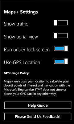
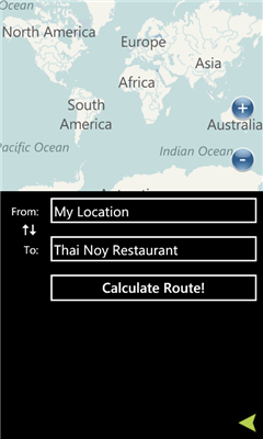
Maps+ - Maps Plus (Maps+) is an easy to use, powerful way to find directions, points of interest, locations, and anything else you're looking for.
A few of the features in our application:
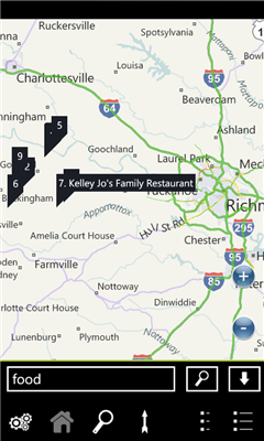
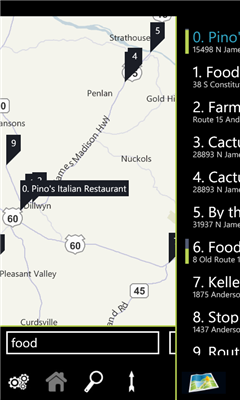
- Quick pop out search list
- Traffic overlay
- GPS calculated direction
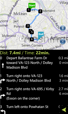
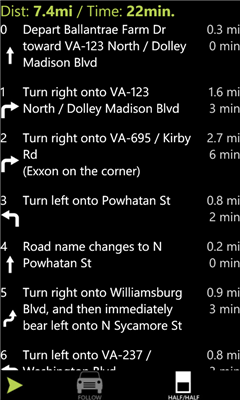
- Route directions with quick switch between map/list mode
- POI Search
- Favorites
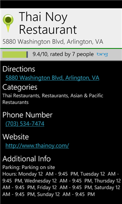
- POI Descriptions including website/phone number/hours
- It's free!
We've optimized the whole experience for speed and ease of use, please provide feedback via the built in feedback button to tell us how we can improve it further for you!
Like it? Share with your friends!
If you got an error while installing Themes, Software or Games, please, read FAQ.
Supported operating systems:
Windows 10 Mobile, Windows Phone 7, Windows Phone 8
Googlemaps Googlemaps - Enjoy Almost all features of Google Maps on your WindowsPhone7
Enjoy The Water-overlay mode, Physical mode, Hybrid mode, Satellite View, Street-View.
You can zoom in and zoom out without any Hindrance
Find My Car Find My Car Have you every parked your car and then went about your day, only to realize at the end of the day that you don't recall where you parked it? Then "Find My Car" is for you.
What's New in This Release:
· Updated to support copy and paste functionality and update Bing maps
Bochum Total Diese Anwendung ist eine ubersicht uber alle Acts bei Bochum Total und das Bermuda-Dreieck
Chicago Maps Chicago Maps - Offline (no data connection necessary!) public transportation maps for the Chicago area. Click on the thumbnails and zoom in for a detailed look.
Includes:
1. an overview of the Chicago Transit Authority system with the ability to zoom into different sections using a map and/or a list
2. Night Owl bus map
Can be used in portrait or landscape view
Map Compare Map Compare - Map Compare allows you to compare 12 different maps from Bing, Google, Yahoo and Open Street Maps side by side on a single screen
Map_launcher Map_launcher - WP7 has a several built in launchers, but the map app does not have one. It's unfortunate because I think it's fairly common that you'd want to have a link to get directions in a mobile app since you are, you know, mobile
Mymaps Mymaps - This is an extra odinary app which collaborates bing maps with gmaps or google maps...just browse on bing with the experience of google maps.
This application is a cross between gmaps and bing maps...
lets call it gingmaps :-p
Cheers and please do review
XMaps XMaps - With xMaps you have the possibility to use the worldwide map data from openstreetmaps.org on your phone. xMaps comes without any map data, you can download any maps in different zoom levels for free. You can zoom in / out and rotate and tilt the map.
Use xMaps to search a point by coordinate or to plan a travel route by car or by foot
Simple OSM Simple OSM is a robust OpenStreetMap (OSM) client to browse and search in maps from the OpenStreetMap project (openstreetmap.org).
OpenStreetMap provides much more geographical and poi data than other well-known maps on the internet. Furthermore it is growing supremely fast
Other Software by developer «Intertouch Media Technologies»:
DCMetro DCMetro - The complete app for the Washington DC Metro! Find the nearest station, check on train arrival times, get directions to a station and more.
Also check up on the most recent disruptions, tweets, and news items published by the metro authority!
Not affiliated with WMATA, all data is gathered from feeds available through WMATA