GPSNarrator is an offroad VOICE based navigation program for PalmOS with bluetooth GPS receiver and GoogleMaps support.
The program has numeric, graphic and voice feedback. You must not look on the display, it tells all the parameters values( e.g.: speed: 0, 10, 20,... km/h or rest time to target: 10, 8, 5,... min ).
Try it, it is very easy to navigate your target without having street map. You hear the actual direction and distance values of target, and you will find very easy your target in the city or in the hills.
If you don't have a GPS receiver, turn on the GPS simulation in the prefs and you can try out the GPSNarrator trial version at home.
You can add max. 10000 points and routes to the database. It's easy to find point's lat/lon coordinates from third party map programs( e.g.: Google Earth).
You can simply right-click the Placemark in Google Earth and select Copy. Then Paste the contents of the clipboard into any text editor and save it with kml extension. This kml file you can import in the POI list window's menu. You can do the same the import of the route.
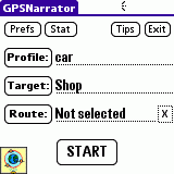
Some simple steps to navigate your target point:
* Create your profile for the used vehicle( car, plane, bike, ship,... ).
* Select a target point.
* Start the navigation.
* The narrator voice( distance, direction, lift, speed, rest time ) will help you to navigate your target.
The voice datas are stored in a separate narrator file(GPSNarSnd.prc).
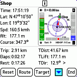
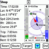
· Display and speak speed, altitude, course, target distance, target lift, target direction, trip, elapsed time and rest time to target.
· Display used satellite number, HDOP, time, lat and lon coordinates.
· Calculates (resetable) statistic: average speed, max speed, trip, elapsed time, navigation start and stop time.
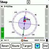
· Display POIs on a resizeable and zoomable map.
· On Centro you can show the selected POI with Google Maps.
· Display live route on the map.
· Adjustable speed and distance unit(km/h, mph, knot; km, mile, nautical mile).
· Visual and sound alerts on exceeding the nearest radar POI's speed limit or the global speed warning limit.
· Automatically starts the navigation on program startup.
· It works as the screen is off(Treo and Centro only).
· You can save the current position.
· Route log can be saved to SD card and database.
· Route editor included: edit, split, join, compact.
· Palm internal clock sync to GPS time.
· Export and import KML(GoogleEarth) point and path.
· GPS simulator for testing without real GPS.
· Full help inside the program.
· Free narrator language files.
· Rock stable C++ code.
Like it? Share with your friends!
Supported operating systems:
Palm OS 5.x
Similar Software:
FON Access Points for New Zealand FON Access Points for New Zealand - FON offers you a new Points of Interest service (POIs). This allows you to download FONspots directly to your navigation device.
What does that mean? You can download a Points of Interest file directly to your navigation device
FON Access Points for Serbia and Montenegro FON Access Points for Serbia and Montenegro - FON offers you a new Points of Interest service (POIs). This allows you to download FONspots directly to your navigation device.
What does that mean? You can download a Points of Interest file directly to your navigation device
FON Access Points for Lithuania FON Access Points for Lithuania - FON offers you a new Points of Interest service (POIs). This allows you to download FONspots directly to your navigation device.
What does that mean? You can download a Points of Interest file directly to your navigation device
FON Access Points for Ethiopia FON Access Points for Ethiopia - FON offers you a new Points of Interest service (POIs). This allows you to download FONspots directly to your navigation device.
What does that mean? You can download a Points of Interest file directly to your navigation device
FON Access Points for Reunion FON Access Points for Reunion - FON offers you a new Points of Interest service (POIs). This allows you to download FONspots directly to your navigation device.
What does that mean? You can download a Points of Interest file directly to your navigation device
FON Access Points for Mauritius FON Access Points for Mauritius - FON offers you a new Points of Interest service (POIs). This allows you to download FONspots directly to your navigation device.
What does that mean? You can download a Points of Interest file directly to your navigation device
2TrackMe 2TrackMe is a GPS logger, a moving map application with realtime map download (from OpenStreetMap), shows Wikipedia entries close to your current location and allows to query Geocaching.com for geocaches near by
FON Access Points for Luxembourg FON Access Points for Luxembourg - FON offers you a new Points of Interest service (POIs). This allows you to download FONspots directly to your navigation device.
What does that mean? You can download a Points of Interest file directly to your navigation device
FON Access Points for Gabon FON Access Points for Gabon - FON offers you a new Points of Interest service (POIs). This allows you to download FONspots directly to your navigation device.
What does that mean? You can download a Points of Interest file directly to your navigation device
Nemerix BT GPS Nemerix BT GPS- simple application that replicates some of the configuration functions of the RCT (Receiver Control Tool) PC application so that the GPS receiver may be configured from a Palm device.
After making the Bluetooth connection to the GPS, the user can perform Factory, Cold, Warm and/or Hot resets
Other Software by developer «Gabor Nagy»:
not found
Comments on GPSNarrator:
Comments not found
If you noted an error or download link is broken, please, report it via this page or use comments.
GPSNarrator is compatible with your device Clie TH55