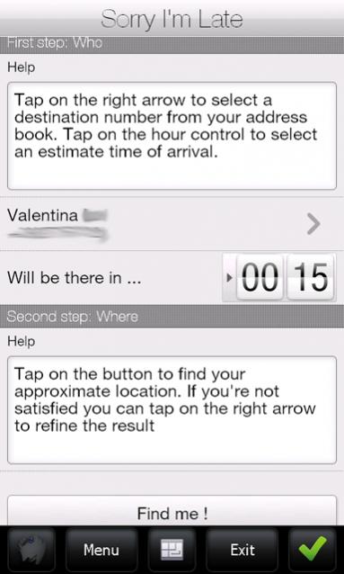
Sorry I'm Late - People are always in a hurry to get somewhere. A common issue is to inform someone waiting for us that we are, let’s say, a bit late and maybe reassure him that we will be there in some time. It would be great if we could send a message to that someone telling him our approximate location and an estimate time to reach the destination (maybe along with some excuses).
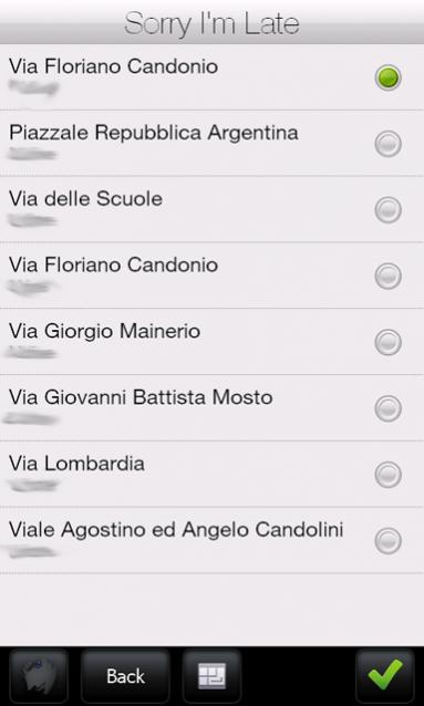
Sorry I'm Late was developed to achieve this task. This application allows a user to get his approximate location and then send it to someone else through an SMS. It has a friendly user interface and uses CellID localization instead of GPS. Also, it sends a more human readable message, unlike other similar applications which use GPS positioning to get a precise localization but then they send Latitude and Longitude coordinates or Google Maps links. This application uses street names instead of coordinates.
· Doesn't require GPS antenna
· Finger friendly UI thanks to SenseSDK from Steady Software
· Call history access to guess the most probable recipients
· Native SMS application used to send message to allow last minute changes
· Currently localized in English and Italian
What's New in This Release:
· added compression support on network calls to reduce bandwidth usage
Like it? Share with your friends!
If you got an error while installing Themes, Software or Games, please, read FAQ.
Supported operating systems:
Windows Mobile 5.0, Windows Mobile 6 Classic, Windows Mobile 6 Professional, Windows Mobile 6.1 Classic, Windows Mobile 6.1 Professional, Windows Mobile 6.5 Professional
GPS Test GPS Test -Free program to test the connection between your Smartphone or Pocket PC and your GPS unit.
This is a free utility to test your GPS unit and is a technology demonstrator for the Chartcross GPS enabled software range.
Please download and use this application to test your mobile device / GPS combination, before buying any of our other GPS software
The Weather Channel Weather can make or break your plans, whether it be business travel or a round of golf. With The Weather Channel for Windows Mobile, you'll have the latest weather information at your fingertips so you can plan more efficiently
FON Access Points for Pakistan FON Access Points for Pakistan - FON offers you a new Points of Interest service (POIs). This allows you to download FONspots directly to your navigation device.
What does that mean? You can download a Points of Interest file directly to your navigation device
VoicePOIer VoicePOIer - VoicePOIer is a full-featured named voice recorder with GPS location tagger. You can make named voice recordings and the GPS location is appended to the end of the file. You can browse the files via GPS distance. Tap on the wave file to play it back.
This program requires that you have both the 'BeanDLL
trackr! Use trackr! to let people know where you are and where you have been. All you need is the Internet, a GPS receiver and your mobile phone (or a mobile phone with an internal GPS receiver)
Efficasoft GPS Utilities (Pocket PC) Efficasoft GPS Utilities for Pocket PC is the complete mobile GPS solution for Windows Mobile Pocket PC. It's the best companion for activities such as touring, hiking, geocaching... By defining a Go To list, you can even use it as a voice driving navigator!
· Designed GPS information overview.
· New! Voice "Go To" navigation function
ExerciseGPSs ExerciseGPSs - ExerciseGPSs uses the GPS on your PocketPC to view on a large display your walking/running/riding speed on a moving graph. You can use this to keep your exercise pace. NOTE: The program does not display/graph 0 speeds.
This program requires that you have both the 'BeanDLL.dll' file ** and ** the runtime files for Visual Basic on your PocketPC computer
MyMotion MyMotion - GPS route recording and playback with customizable spoken feedback of speed, distance and time. Uses a moving map to show progress as well as textual output. Maps can be generated from Google Earth installed on a PC using a map creation tool. Allows user to record a route then load it up as a reference for live comparison the next time it is traversed
VirtualGPS Virtual GPS is a free, small utility, which fully emulates GPS module and returns your location (by using cellular towers).
Accuracy of coordinates is about 200m in urban area and up to 5km in countryside. Screenshots are explaining how to use VirtualGPS with navigation software (e.g. "Google Maps")
Other Software by developer «ste09»:
Mobile First Aid Mobile First Aid - According to a recent study (Gray, 2008) there are abount 1.8 mobile phones per person around the world. Since everyone of us can find himself in the need to give some first aid assistance to someone injured, it is simple to merge these two data and say "why don't give these people a first aid application to be installed on their mobile phones


")


