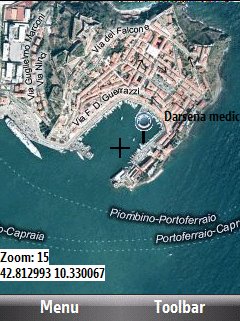
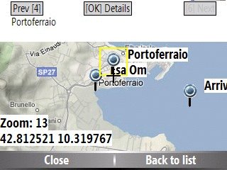
Bluemapia Mobile - View Maps, Search places and geotagged Wikipedia articles, GPS. Mobile Application for bluemapia, the new Web & Mobile Social Mapping for Boaters
- View Maps (OpenStreetMap and other web map servers)
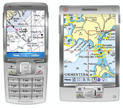
- Support BSB/NOAA Charts and raster, calibrated charts
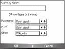
- Search places by name and bluemapia content from the web site
- View geotagged Wikipedia articles on the map
- Use a GPS to display your position on the map and set a terget destination
- Create tracks (gpx file)
- Shoot and upload photos and text to bluemapia for community sharing
Like it? Share with your friends!
If you got an error while installing Themes, Software or Games, please, read FAQ.
Supported operating systems:
Windows Mobile 2003, Windows Mobile 5.0, Windows Mobile 6 Classic, Windows Mobile 6 Professional, Windows Mobile 6.1 Classic, Windows Mobile 6.1 Professional, Windows Mobile 6.5 Professional
Similar Software:
Psiloc TinyGPS Psiloc TinyGPS enables receiving information about location of your phone in your GSM network. It also shows name of your current location (if your GSM operator provides it).
You can teach your phone locations which are important for you like: home, school, work, train station, church etc. Then you can set up events based on entering or leaving chosen location
TravelReaderer TravelReaderer - TravelReaderer uses the GPS on your PocketPC to find your current latitude/longitude and says the readings in a computer voice. You can also view and download a map of your current position from the Google.com map service. You can customize the maps via the options setting in the toolbar.
This program requires that you have both the 'BeanDLL
RulerGPSed RulerGPSed - RulerGPSed uses the GPS on your PocketPC to calculate geodesic distance in 3 formats between two points specified by the latitude/longitude of your GPS using "The Vincenty inverse formula for ellipsoids" (accuracy to within 0.5mm, or 0.000015").
This program requires that you have both the 'BeanDLL
GPS Dashboard GPS Dashboard- View the status of the GPS on your phone with this cool Dashboard
FileGPSer FileGPSer - FileGPSer uses the GPS on your PocketPC to find your current GPS location and allows you to re-name files on your PocketPC with the GPS location tag. You can also explore the files in a folder in distance order based on your current GPS. Tap on the file to view the file in the associated application.
This program requires that you have both the 'BeanDLL
FON Access Points for Togo FON Access Points for Togo - FON offers you a new Points of Interest service (POIs). This allows you to download FONspots directly to your navigation device.
What does that mean? You can download a Points of Interest file directly to your navigation device
AgMapper AgMapper - Create maps using your Windows Mobile device. Measure lengths and view areas without the desktop PC.
AgMapper makes it easy to map what ever you like and share it with other software packages by using the very common shape file format (.shp) to store your mapping data.
Load images onto your map created using the FREE AgMapper Image Converter
Where is... Where is... is a GPS tracking application for Windows Mobile devices. It gives you a free perception of distance and direction from your destination without any connection to the internet or an expensive program of navigation
KidsGPSer KidsGPSer - KidsGPSer can be used to update your parents/family of your GPS location at regular intervals. The program gets the GPS from your PocketPC and sends the GPS location to the FTP server. You can get the location of all kids with the PocketPC KidsGPSs.
This program requires that you have both the 'BeanDLL