Categories: Internet & Communications, Travel & Navigation
Upload date: 8 Jun 12
Developer: DEWA
License: Freeware
Downloads: 2371 File Size: 1226 Kb
DEWA - Welcome to the Mobile World of DEWA.
This application offers the following functionality:
- Bill Enquiry
- Log Complaint with GPS Location and Instant Photo
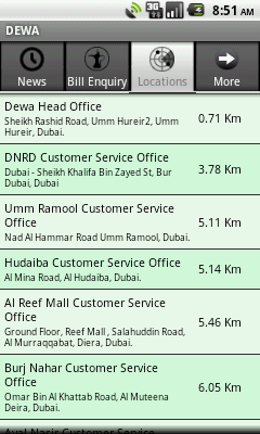
- Customer Service Office Information:
- Nearest Customer Service Office Location
- Office Detailed Address
- Phone Numbers
- Working Hours
- Online Access to DEWA website
- Nearest Customer Service Office Location
- Customer Care Center Email ID
- Send Office Details as a Business Card
- Add Contacts Detail to the Contact List
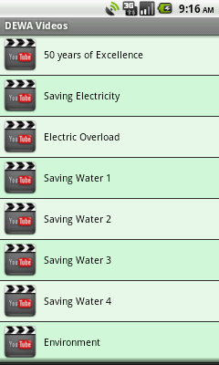
- Videos about conservation Tips
- DEWA News
- DEWA Events
What's New in This Release:
· Version Checking
What's New in 1.4:
· Supports Push Notifications
· Bill payment through ePay
· Payment Channels & its location on Google Maps
· Help
· Feedback
· Application Information
What's Newin 1.3:
· Payment Channels and its location on Google Maps
· Help
· Application Feedback
· Application Information
· Bill Payment through ePay
Like it? Share with your friends!
Supported operating systems:
Google Android 1.5, Google Android 1.6, Google Android 10.x, Google Android 2.0, Google Android 2.1, Google Android 2.2, Google Android 2.3, Google Android 3.0, Google Android 3.1, Google Android 3.2, Google Android 4.0, Google Android 4.1, Google Android 4.2, Google Android 4.3, Google Android 4.4, Google Android 5.x, Google Android 6.x, Google Android 7.x, Google Android 8.x, Google Android 9.x
Similar Software:
Android Photo GeoTag Android Photo GeoTag - Take pictures with your mobile phone and incorporate the data of the geographical location. The application allows you to include in the photographs, data from the GPS receiver, along with a brief note. If you know the coordinates, not having the GPS receiver, you can also handwrite geographic data
Phone Tracker (GPS Phone Tracking) Phone Tracker (GPS Phone Tracking) - The Phone Tracker is a free service that uses GPS technology to help you follow friends/family and see their exact location on a map. You will be able to securely track both iPhones and Androids, view their movements, and see up to 72 hours of their travel location history. ✓ Follow your child's movements during the day
AugSatNav Walk AugSatNav is an augmented reality navigation system which overlays walking directions upon a live video feed of the path or road ahead.
With AugSatNav there is no need to follow instructions or interpret maps - you can simply find your way by walking along the route highlighted by a bright white line
Mock locations - Fake GPS path Mock locations - is an application which will help you hide your location. With its help you can set 2 certain points and make your device move between these points.When you will view the covered distance on google maps, it will show you not the place you were for real
uWho Find Me uWho Find Me will send a text message with your current location to help people find you.Simply have your friend or family member send you a text with your uWho Find Me Access code as the body of the text and your current location will be sent back.
Notes:
Application runs on phone boot up
Life360 Life360 turns your phone into the ultimate safety device. * Top 10 App Worldwide - Google Android Developer Challenge* Life360 turns your phone into the ultimate safety device and let’s you know
Place Nearby Place Nearby - This application is all about searching for a desire location on map anytime, anywhere or anyplace.
This application just required a high speed internet connection, Network / GPS enabled device to search for your desire location.
This application will show you the live traffic near by your present location
GPS Map Camera use GoogleMap GPS Map Camera use GoogleMap - The main feature of the 'GPS Map Camera':
When you take a piture with GPS enabled, it will paste the google map, address and weather to picture. (GPS latitue/longitude also include in the information)
Please enable your network and GPS function before using this application
NAVIGON select NAVIGON MobileNavigator - GPS Navigation NAVIGON MobileNavigator GPS Navigation Very important: ONLY customers who already have one of the previous full versions bought can use this software as an update
ParkLeitSystem ParkLeitSystem is a car-park-routing system. It shows you, according to your GPS position, the nearest city with a car-park-routing system and gives you a list with all available car-parkings and shows how many free places there are. With a click on the parking it switches to google maps and shows you the position of the parking
Other Software by developer «DEWA»:
DEWA (iPhone) DEWA - Welcome to the Mobile World of DEWA
DEWA (iPad) DEWA - Welcome to the Mobile World of DEWA


")
")


")
")