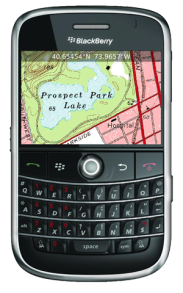
With TopoExplorer you will discover your surroundings on topographic maps even in remote areas assisted by GPS and without the need of the wireless network connection.
Offline Maps - No wireless network connection needed.
Shows GPS position in different coordinate systems.
Large map support from memory card.
Free map packs cover most areas already.
Detailed map packs for more detailed coverage.
TopoExplorer works worldwide!
Features
Free of charge: TopoExplorer is available for free - download.
Moving map navigation: Easy map navigation with sophisticated trackball control.
GPS location on map: The device's current GPS location is shown on the map and can be visualized in three coordinate formats for professional usage.
Automatical map selection: The best map for your location is selected automatically.
On-Device maps: Map packs are stored on the device's memory card only. No internet connection / data plan is required.
Spot for BlackBerry Spot combines your BlackBerry and Bluetooth GPS receiver into the most powerful positioning tool
Tokyo Disneyland Locations Tokyo Disneyland Locations - This app adds Tokyo Disneyland Locations to BlackBerry®'s default map.
Press "P" or "N" on keyboards to switch locations after selecting "Invoke Attractions." from Menu.
You can select "Start GPS Navigation", "Add to Favorites", and other options
TrackMyJourney (BlackBerry) TrackMyJourney (BlackBerry) is a mobile application that uses GPS data to provide a number of functions, including navigation, location tracking, map display and route plotting. It receives its location coordinates by communicating via Bluetooth with a separate GPS receiver, or via the phones internal GPS if supported
Taegu subway This is a simple version of viewing subway maps of Taeguin Korea.
It will be kept updating more functionalities such as route finder, time table and other subway maps
Travelling Volkswagen An application designed for travelers who like to see the world driving his car. Through the menu, you can access a selection of routes passing through various Spanish regions, France, Portugal and neighboring Andorra
Maps (-) Maps (-) - Offline maps. Cache maps to SD card and use them when traveling without network coverage. Ads supported version
Sanoodi SMap GPS tracking Sanoodi SMap GPS tracking- NOW WITH IMPROVED TWITTER integration ! SMap GPS tracking app, share routes on Twitter and Sanoodi.com
Features:
- Two screens: a Pace Screen and a route Summary Screen
Locle Locle is a mobile application that lets users see where their friends and family are without the need for GPS. Wherever you are, always find out where people are and meet them for lunch, drinks or whatever you want to do. Just make sure you don't miss out on anything
Other Software by developer «Skylab Mobilesystems Ltd.»:
Spot Spot - Geocaching, hiking, biking, outdoor activities. Combine the power of GPS with worldwide maps and a flexible waypoint management. Orientation and routing enables you to find interesting places, store and share them with others
ContactMapper Geocodes your contacts from the address book and shows them on a satellite or topographic map. The 2-click-on-map-application!
GPS SightFinder GPS SightFinder looks for sights, landmarks and other interesting places close to your current location. Descriptive search results with thumbnail images link to the corresponding Wikipedia articles for detailed up-to-date information.
GPS SightFinder is a Windows Mobile application for Smartphones and PocketPCs with built-in GPS or a connected Bluetooth GPS device
Spot for BlackBerry (OS 4.2) Spot combines your BlackBerry and Bluetooth GPS receiver into the most powerful positioning tool
TopoExplorer for Touch Screen Devices ONLY TopoExplorer for Touch Screen Devices ONLY
Features | Free Download
With TopoExplorer you will discover your surroundings on topographic maps even in remote areas assisted by GPS and without the need of the wireless network connection
Spot for BlackBerry Spot combines your BlackBerry and Bluetooth GPS receiver into the most powerful positioning tool
LocalWeather LocalWeather is an application for Windows Mobile Smartphones and PocketPCs providing location-based weather information. It retrieves the current location from a GPS receiver, looks up the nearest weather station and fetches information on the current weather conditions from the Internet
GPS Waypoint Manager - Free BETA GPS Waypoint Manager - Free BETA - The GPS Waypoint Manager for BlackBerry® Smartphones is a comprehensive tool for managing waypoints and points of interests (POI) right on your phone. By using the GPS in your device, your can accurately pin-point your location and map out other points as well. You also have the ability to import/export .kmz and
MobileTracker MobileTracker
The tracklog application for mobile devices!
Records a tracklog.
Elevation can be tracked.
Configurable timespan between positions.
Extensive statistical information

")


")


")


")


