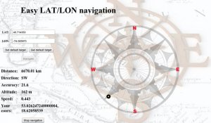
Easy LAT-LON Navigation - navigate You directly to given latitude and longiude, and give You information about: distance from Your position, direction of Your course, accurancy, altitude, speed and coords of Your position
Like it? Share with your friends!
Supported operating systems:
RIM BlackBerry OS 4.6, RIM BlackBerry OS 4.7, RIM BlackBerry OS 5.0, RIM BlackBerry OS 6.0
Similar Software:
SpeedLimit SpeedLimit-this application was developed in cooperation with wikispeedia.org and is designed to allow you to quickly and easily add speed limit data to their database while you are passing a speed limit sign (Please do not use while driving, make sure you are a passenger in the car)
GPSCalc Simply calculate the distance between points on earth. Compare the distance over the surface with the distance via the rhumb line (includes rhumb bearing too)
aiSpot (for touch screen) aiSpot (for touch screen) is a professional application that greatly expands your mobile phone’'s GPS capabilities. Once turned on, aiSpot constantly monitors the available GPS Satellites and updates 13 essential parameters of your trip
BreadCrumbs BreadCrumbs - Every wonder how to get back to your camp site without getting lost or deviating from your original trail? Well now you can drop bread crumbs with this simple app as you wander the wilderness with the ease of mind that you can take the same trail back to your point of origin
SMap SMap -allows you to record and manage your running, hiking, cycling, MTB or sailing routes and easily upload them onto the Sanoodi website live via GPRS or later when you connect your mobile to your desktop computer.
· Two screens: a Pace Screen and a route Summary Screen
Compass This wonderful fully-featured Compass uses the built-in GPS to show your heading, speed, latitude and longitude and where True North is on a variety of stunning backgrounds. Compass is GPS-based and you MUST BE MOVING to use it
Locify With Locify you can explore interesting places near you from Wikipedia, seek for geocaches, display map where you are (or you want to go), twitter your location, save interesting places from phone or web sync them and even navigate to them... and much more.
Locify is free application for common mobile phone
Speedometer Speedometer - A GPS based speedometer for your phone. If you are in a train or a bus, use this amazing tool to see your current speed. You can switch between Kilometer an hour (Kmph) or Miles per hour (MPH) scale. If you want to continuously monitor the speed, you can also keep the back-light of your phone turned on continuously. Keep an eye on your speed. Enjoy
Tacho Tacho - A graphical indicator which displays values like current speed, average speed, elevation profile, distance and elapsed time.
Beside the simple but very smooth graphical interface with high contrast it also has some very smart functionalities like starting/stopping the time measurement toggled by movement
Compass Lite Compass Lite - This wonderful 'Ancient Mariner' compass uses the built-in GPS in the device to show your line of travel, speed, latitude and longitude and where North is in relation to your heading. To establish a line of travel, you must be moving.
This is the companion program to our more fully-featured Compass application
Other Software by developer «Marina Zielinska»:
not found
Comments on Easy LAT-LON Navigation:
Comments not found
If you noted an error or download link is broken, please, report it via this page or use comments.
Easy LAT-LON Navigation is compatible with your device BlackBerry Bold 9900 (RIM Pluto)

")


")


