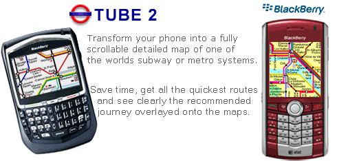
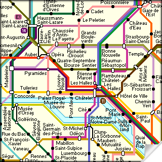
Transform your Blackberry into a fully scrollable detailed map of the Paris Metro system.
Plan journeys on the Paris Metro system, have the quickest routes to hand, with all the details you need including line changes, platform directions and accurate journey times.
See a clear informative display of the route overlaid on the system map. The journey overlay indicates the direction of travel, the colour code of the line your travelling on, and where to make changes along your journey.
Only $10.00
One of a series of Tube 2 product from Visual IT, many cities from all around the world are available.
Like it? Share with your friends!
Supported operating systems:
RIM BlackBerry OS 2.0, RIM BlackBerry OS 3.x, RIM BlackBerry OS 4.0, RIM BlackBerry OS 4.1, RIM BlackBerry OS 4.5, RIM BlackBerry OS 4.6, RIM BlackBerry OS 4.7, RIM BlackBerry OS 5.0
Similar Software:
Google Maps Google Maps - I'm always lost when it comes to working a GPS guidance system, to those who just want a simple map system would be the best. An answer to my prayer cam when google finally released Google Maps and Local for the Blackberry.
It currently does not work for all blackberry models but only the lastest ones
aiSpot aiSpot is a professional application that greatly expands your mobile phone’'s GPS capabilities. Once turned on, aiSpot constantly monitors the available GPS Satellites and updates 13 essential parameters of your trip
Bing Bing is your central stop for maps, directions, and local searches.
See the quickest route to the airport.
* Get directions to just about anywhere, by car or on foot.
* Browse nearby map locations by category, rating, and distance.
Uncover that hot new shoe store.
* Painlessly find nearby businesses, restaurants, and movie theater showtimes
MetrO (BlackBerry) Métro is your free guide to public transport systems worldwide (about 400 cities covered now)
TopoExplorer for Non-Touch Screen Devices ONLY TopoExplorer for Non-Touch Screen Devices ONLY
Features | Free Download
With TopoExplorer you will discover your surroundings on topographic maps even in remote areas assisted by GPS and without the need of the wireless network connection
Mobile GMaps Mobile GMaps is a FREE application that displays maps from various sources like Yahoo! Maps, Windows Live Local, Ask.com and Open Street Map on Java J2ME-enabled mobile phones, PDAs and other devices. MGMaps can connect to a GPS receiver over bluetooth or use internal GPS features on some phones in order to automatically display the map for your current position
e-Mobile Family Locator e-Mobile Family Locator-
Locate device and people
Locate device and people by sending a "locate" text message
BigTinCan Mapper BigTinCan Mapper- Mapper is a cool app that let you take part in the global OSM community and "map your world" by adding Points of Interest (POIs) easily and quickly from a smartphone whenever and wherever you are
Tube 2 Chicago (UIQ) Tube 2 Chicago (UIQ) - This map package for Tube 2 consists of a fully scrollable detailed map of the Chicago metro & commuter rail system.
It includes the rapid transport system of subway and elevated lines, in addition to the many commuter rail lines. The map also indicates how the Amtrak intercity routes intersect with the cities transport network
Tube 2 Baltimore (UIQ) Tube 2 Baltimore (UIQ) - This map package for Tube 2 consists of a fully scrollable detailed map of the Baltimore metro & rail system.
Plan journeys on this system, list details of the quickest routes and see a superb animated display of your journey tracking around the system map
London Master A-Z London Master A-Z - This clear and colourful high quality map covers the same area as the market leading A-Z "Master Atlas of Greater London Street Atlas". The familiar look makes this by far the easiest London iPhone map to use. The map is drawn by real cartographers with the detailed care and the human touch of emphasis and colour that A-Z are famous for
Hong Kong Subway for iPad by Zuti Hong Kong Subway for iPad by Zuti - Hong Kong Metro map makes it easy to travel in and around the city using the MTR transit railway, MTR light rail, MTR Airport Express, Trams, Cable Car and Ferry services
Tube Tyne & Wear (Palm OS) Tube Tyne & Wear (Palm OS) - An award winning and highly acclaimed Palm OS application that guides you around the metro system of Tyne & Wear. An essential addition to your Palm device for locals and vistors alike.
Tube's features include:
A detailed clear colour (or grey scale) map of the transport system fully scrollable.
Quick find station utility
Edinburgh Mini A-Z Edinburgh Mini A-Z - This street map of Edinburgh covers an area extending to Cramond, Granton, Leith, Portobello, Musselburgh, Whitecraig, Dalkeith, Bonnyrigg (part), Loanhead, Fairmilehead, Juniper Green, Currie, Balerno, and Edinburgh Airport.
Major buildings are colour-coded to indicate places of interest and other buildings that are open to the public
Tube Frankfurt (Palm OS) Tube Frankfurt (Palm OS) - An award winning and highly acclaimed Palm OS application that guides you around the metro (S-Bahn / U-Bahn) system of Frankfurt. An essential addition to your Palm device for locals and tourists alike.
Tube's features include:
A detailed clear colour (or grey scale) map of the transport system fully scrollable.
Quick find station utility
Tube 2 Boston (Palm OS) Tube 2 Boston (Palm OS) - This map package for Tube 2 consists of a fully scrollable detailed map of the Boston metro & commuter rail system.
Plan journeys on this system, list details of the quickest routes and see a superb animated display of your journey tracking around the system map
Tube 2 Amsterdam Pro (UIQ3) Tube 2 Amsterdam Pro (UIQ3) - This map package for Tube 2 consists of a fully scrollable detailed map of the Amsterdam tram & metro system and linked street maps of central Amsterdam.
Plan journeys on the tram & metro system, list details of the quickest routes and see a superb animated display of your journey tracking around the system map
GB Major Road Atlas (UIQ) GB Major Road Atlas (UIQ) - This map package is an essential addition to your Tube 2 maps if you drive in and around Great Britain.
This reference map gives you a clear view of all the major roads in the whole of Great Britain, you can use the quick find feature to locate any of the 30,000 + GB towns and villages in the database


")


 Transform your Blackberry into a fully scrollable detailed map of the Paris Metro system.


")
")


")
")


")

")
")
")
")