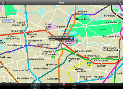
Berlin Metro for iPad by Zuti - This Berlin Metro map makes it easy to travel in and around the city using the Metro (U-Bahn) Suburban Rail (S-Bahn) and Tram (MetroTram and Straßenbahn) systems. Unlike old fashioned schematic style maps this product contains a geographically accurate central area showing major streets, parks and places of interest etc, allowing the user to easily get their bearings.
MAP
The map is hand drawn by Visual IT and provides a unique geographically based view of Berlin with many places of interest drawn directly on the background so you can easily get your bearings when traveling around the city. You can also use your inbuilt GPS to accurately locate and track yourself within the city centre and see the nearest transportation stop and distance to it. This is the only public transportation route planner with this ability.
Tap on the map for location information, use the inbuilt search feature or choose from a list of locations. Places of interest, museums, hotels, parks, restaurant, shops, hospitals, streets, etc, are also included. The route planner will automatically suggest the nearest station to any place of interest you select.
MINUTE MAP
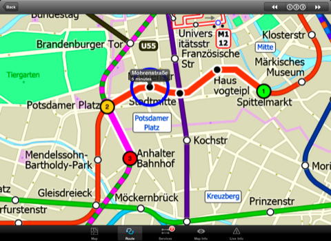
Another great feature is the “Minute Map” option which allows you to see the travel times from a start point to all other locations on the map. This is a unique way to view the topology of a city and gauge traveling times.
ROUTING
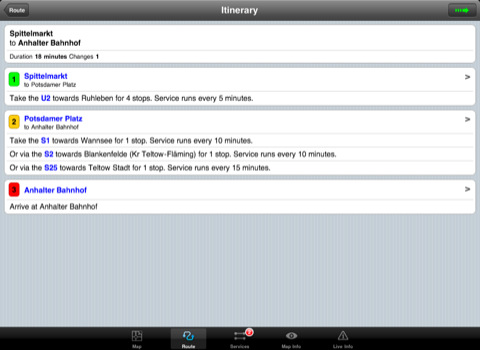
The application does not require an internet connection and will always be available to display a clear and detailed view of the city transport systems, plus list and animate the optimum route for your journey. This product provides the fastest route calculations of any mobile routing application (virtually instantaneous) using actual published journey times with the ability to select the quickest route or the route with the least changes.
· Designed for the first time visitor and experienced commuter.
· Simple, fast and intuitive to use.
· Full offline map and routing, works underground, no internet connection required.
· Animates the route and allows tracking of the journey using GPS
· Instantly see the route of any transport service drawn on the map.
· Save and recall favourite and recent journeys.
· Take me home feature.
· Unique "Minute Map" feature allows quick view of all journey times from a start location.
· Services can be turned on or off, routing round problems.
· Works in landscape or portrait mode.
· GPS location and tracking.
· Streets, Places of interest etc built into the application.
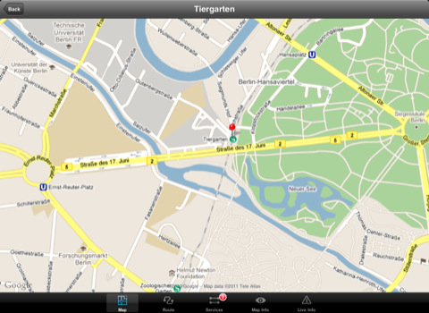
· View locations on Google map.
Like it? Share with your friends!
If you got an error while installing Themes, Software or Games, please, read FAQ.
Supported operating systems:
Apple iOS 10.x (iPad), Apple iOS 11.x (iPad), Apple iOS 12.x (iPad), Apple iOS 4.2.x (iPad), Apple iOS 4.3.x (iPad), Apple iOS 5.0 (iPad), Apple iOS 6.0 (iPad), Apple iOS 7.0 (iPad), Apple iOS 8.x (iPad), Apple iOS 9.x (iPad), Apple iPhone OS 3.2.x (iPad)
Other Software by developer «Visual IT»:
Tube 2 Barcelona (UIQ) Tube 2 Barcelona (UIQ) - This map package for Tube 2 consists of a fully scrollable detailed map of the Barcelona metro & rail system.
Plan journeys on the metro system, list details of the quickest routes and see a superb animated display of your journey tracking around the system map
TUBE 2 Rome Pro (Palm OS) TUBE 2 Rome Pro (Palm OS) - This map package for Tube 2 consists of a fully scrollable detailed map of the Rome metro & rail system and linked high quality street maps of central Rome.
Plan journeys on the metro system, list details of the quickest routes and see a superb animated display of your journey tracking around the system map
Tube 2 Hong Kong (UIQ3) Tube 2 Hong Kong (UIQ3) - This map package for Tube 2 consists of a fully scrollable detailed map of the Hong Kong metro & rail system.
Plan journeys on this system, list details of the quickest routes and see a superb animated display of your journey tracking around the system map
Tube 2 Baltimore (UIQ) Tube 2 Baltimore (UIQ) - This map package for Tube 2 consists of a fully scrollable detailed map of the Baltimore metro & rail system.
Plan journeys on this system, list details of the quickest routes and see a superb animated display of your journey tracking around the system map
Tube Sydney (Palm OS) Tube Sydney (Palm OS) - An award winning and highly acclaimed Palm OS application that guides you around the complex rail system of Sydney. An essential addition to your Palm device for locals and tourists alike.
Tube's features include:
A detailed clear colour (or grey scale) map of the transport system fully scrollable.
Quick find station utility
San Francisco Metro 10 for iPad San Francisco Metro 10 for iPad - The new San Francisco Metro 10 application makes it easy to travel in and around the city using the Metro (BART), Streetcar, Light Rail(MUNI), Ferry and Presidio shuttle bus services
Tube 2 Chicago Pro (UIQ) Tube 2 Chicago Pro (UIQ) - This map package for Tube 2 consists of a fully scrollable detailed map of the Chicago metro & commuter rail system and linked street maps of central Chicago.
Plan journeys on the metro system, list details of the quickest routes and see a superb animated display of your journey tracking around the system map
Tube 2 London (UIQ) Tube 2 London (UIQ) - This map package for Tube 2 consists of a fully scrollable detailed map of the London Underground system.
Plan journeys on the London Underground system, list details of the quickest routes and see a superb animated display of your journey tracking around the system map
London Mini A-Z London Mini A-Z - This map is a digital rendition of the famous "London A-Z Mini Atlas" and covers an area from West Hendon in the North West to Grove Park in the South East. Add this application to your iPhone or iPod Touch and you will have instant access to all 352 pages of the London Mini A-Z printed map
Tube 2 Barcelona Pro (Palm OS) Tube 2 Barcelona Pro (Palm OS) - This map package for Tube 2 consists of a fully scrollable detailed map of the Barcelona metro & rail system and linked street maps of central Barcelona.
Plan journeys on the metro system, list details of the quickest routes and see a superb animated display of your journey tracking around the system map


")
")
")
")
")

")
")

")