US Terrain Intelligence for Android - The Outdoor Navigation software is your best friend through your adventures in the wild.
Go into the outdoors with confidence and enjoy your activities without worrying about the tools to help you navigate. Your Outdoor Navigation app is made by the people who have been developing this software since 2003 across multiple platforms. Be sure that you will stay ahead of the rest with continuous updates and relevant tools.
It is an excellent tool for biking, jogging, skiing, hiking, geocaching, boating, flying and many other sporting activities.
United States Terrain Intelligence will give you access to the most sophisticated Ground Guidance technology and allow you to take advantage of services that have only been available to military personal until now.
Terrain Intelligence takes into account a multitude of variables, including elevation, land cover and aerial aspects to calculate the best possible route.
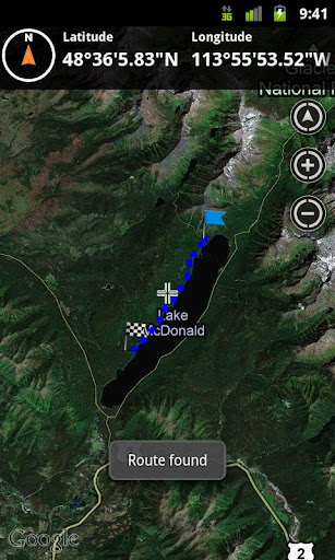
To plan your your off road activities:
· Select Terrain Intelligence as Routing Type in Options
· Route Settings
· Tap on the map to select start and end off road points
· Route will be calculated using Terrain Intelligence service
This plugin works only in the USA.
Installation instructions:
Outdoor US Terrain Intelligence is an add-on for the free Outdoor Navigation application. You need to have your Outdoor Navigation installed to be able to use Outdoor US Terrain Intelligence.
Download and install Outdoor US Terrain Intelligence on your Android device. Start the Outdoor US Terrain Intelligence plugin to complete the license checking: when activation will be completed then the icon will be removed (you need to restart your device to hide the icon) and the plugin will be used inside Outdoor Navigation application
What's New in This Release:
· Bug fixing
Like it? Share with your friends!
Supported operating systems:
Google Android 10.x, Google Android 2.1, Google Android 2.2, Google Android 2.3, Google Android 3.0, Google Android 3.1, Google Android 3.2, Google Android 4.0, Google Android 4.1, Google Android 4.2, Google Android 4.3, Google Android 4.4, Google Android 5.x, Google Android 6.x, Google Android 7.x, Google Android 8.x, Google Android 9.x
Similar Software:
Chinese Restaurant Find Chinese restaurants in US easily. Move the map and press menu "Restaurant" to find in different area. Enter zip/address by pressing menu "Location" Zoom the map and press menu "Restaurant" to search in different range
Indias Republic Day Indias Republic Day - In India, Republic Day honours the date on which the Constitution of India came into force on 26 January 1950 replacing the Government of India Act (1935) as the governing document of India
Binoculars Zoomer Tool Binoculars Zoomer Tool - Use you android phone as Binoculars.
You can use the power of your phone camera to ZOOM and to see the thing more closer.
If you want to have a zoomer tool in you packet that this is the application for you.
Feature:
-Take a closer look to the things with this app
City of Griffin City of Griffin - Public service one stop app for the City of Griffin, GA. Gives citizens the ability to quickly contact local government, police, and fire. App also offers the ability to pay bills, traffic citations, etc. Citizens can also report city issues like pot holes and damaged street lights through the app
Flightradar 24 Flightradar 24 - follow the plane flights in real time mode. You can view the entire route, get to know the full name of the flight and even get details on the plane of the airline company. All you need to do is to select the country you are interested in and show all planes flying in that direction on the map
Fare Meter Fare Meter is your new fare calculator - both when travelling and when not travelling. It allows you calculate fares for multiple services (Auto, Cab services) between two locations right in the comfort of your home. It also shows the route on Google maps. The application comes pre-configured with 17 cities in India, but you can use it anywhere as long as you know the fares
Wristband Wristband - Wristband uses the SongKick and Bandcamp APIs to search for local shows, gives you a playlist of music in your area, and gives you directions to the show. Looking for something to do tonight? Wristband helps you discover new local music. Support your scene.
What's New in This Release:
· Improved performance of coverflow
Fancy Dining Fancy Dining - This app is all about posting taking pics of favorite dishes you love to eat! By sharing it along with your other accounts Facebook and Twitter
Beautiful National Parks Beautiful National Parks - National parks are naturally beautiful. Most parks were declared parks to preserve the wild beauty that makes them so amazing. While nearly all these protected areas are pretty, a number are simply amazing in their beauty. Take a look at the list of the most beautiful national parks in the world
Dukan Line Using Dukan line app you can view local business resigstered at DukanLine.com and can also submit you business vai Dukan Line app
Other Software by developer «GPS Tuner»:
Outdoor Compass for Android Outdoor Compass for Android - The Outdoor Navigation software is your best friend through your adventures in the wild.
Go into the outdoors with confidence and enjoy your activities without worrying about the tools to help you navigate. Your Outdoor Navigation app is made by the people who have been developing this software since 2003 across multiple platforms
Outdoor Speedometer for Android Outdoor Speedometer for Android - The Outdoor Navigation software is your best friend through your adventures in the wild.
Go into the outdoors with confidence and enjoy your activities without worrying about the tools to help you navigate. Your Outdoor Navigation app is made by the people who have been developing this software since 2003 across multiple platforms
GPS Tuner Atlas Full Version with South America Basic Map Content GPS Tuner Atlas Full Version with South America Basic Map Content is designed specifically for off-road use: its large buttons, selectable tool window size, multiple Compass views and the built-in Tele Atlas map makes it extremely user-friendly and reliable
GPS Tuner Essentials Full Version with France, Monaco, Belgium, Switzerland Basic Map Content GPS Tuner Essentials Full Version with France, Monaco, Belgium, Switzerland Basic Map Content is designed specifically for off-road use: its large buttons, selectable tool window size, multiple Compass views and the built-in Tele Atlas map makes it extremely user-friendly and reliable
GPS Tuner Essentials Full Version with Germany, Austria, Switzerland Basic Map Content GPS Tuner Essentials Full Version with Germany, Austria, Switzerland Basic Map Content is designed specifically for off-road use: its large buttons, selectable tool window size, multiple Compass views and the built-in Tele Atlas map makes it extremely user-friendly and reliable
GPS Tuner Essentials Full Version with Canada Basic Map Content GPS Tuner Essentials Full Version with Canada Basic Map Content is designed specifically for off-road use: its large buttons, selectable tool window size, multiple Compass views and the built-in Tele Atlas map makes it extremely user-friendly and reliable
GPS Tuner Essentials Full Version with Brazil Basic Map Content GPS Tuner Essentials Full Version with Brazil Basic Map Content is designed specifically for off-road use: its large buttons, selectable tool window size, multiple Compass views and the built-in Tele Atlas map makes it extremely user-friendly and reliable
GPS Tuner Atlas Full Version with Asia Pacific Basic Map Content GPS Tuner Atlas Full Version with Asia Pacific Basic Map Content is designed specifically for off-road use: its large buttons, selectable tool window size, multiple Compass views and the built-in Tele Atlas map makes it extremely user-friendly and reliable
GPS Tuner Essentials Full Version with Nordic Countries Basic Map Content GPS Tuner Essentials Full Version with Nordic Countries Basic Map Content is designed specifically for off-road use: its large buttons, selectable tool window size, multiple Compass views and the built-in Tele Atlas map makes it extremely user-friendly and reliable

")