US Terrain Intelligence for Android - The Outdoor Navigation software is your best friend through your adventures in the wild.
Go into the outdoors with confidence and enjoy your activities without worrying about the tools to help you navigate. Your Outdoor Navigation app is made by the people who have been developing this software since 2003 across multiple platforms. Be sure that you will stay ahead of the rest with continuous updates and relevant tools.
It is an excellent tool for biking, jogging, skiing, hiking, geocaching, boating, flying and many other sporting activities.
United States Terrain Intelligence will give you access to the most sophisticated Ground Guidance technology and allow you to take advantage of services that have only been available to military personal until now.
Terrain Intelligence takes into account a multitude of variables, including elevation, land cover and aerial aspects to calculate the best possible route.
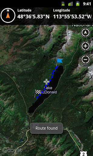
To plan your your off road activities:
· Select Terrain Intelligence as Routing Type in Options
· Route Settings
· Tap on the map to select start and end off road points
· Route will be calculated using Terrain Intelligence service
This plugin works only in the USA.
Installation instructions:
Outdoor US Terrain Intelligence is an add-on for the free Outdoor Navigation application. You need to have your Outdoor Navigation installed to be able to use Outdoor US Terrain Intelligence.
Download and install Outdoor US Terrain Intelligence on your Android device. Start the Outdoor US Terrain Intelligence plugin to complete the license checking: when activation will be completed then the icon will be removed (you need to restart your device to hide the icon) and the plugin will be used inside Outdoor Navigation application
What's New in This Release:
· Bug fixing
Like it? Share with your friends!
Supported operating systems:
Google Android 10.x, Google Android 2.1, Google Android 2.2, Google Android 2.3, Google Android 3.0, Google Android 3.1, Google Android 3.2, Google Android 4.0, Google Android 4.1, Google Android 4.2, Google Android 4.3, Google Android 4.4, Google Android 5.x, Google Android 6.x, Google Android 7.x, Google Android 8.x, Google Android 9.x
Similar Software:
Taxido Quick taxi from your mobile phone. Country: Belarus, Georgia, Kazakhstan, Latvia, Lithuania, Moldova, Poland, Romania, Russia, Slovakia, Ukraine, Czech Republic, Estonia
Worldpackers: Backpacking, volunteer work, gap year Worldpackers - is an application for travellers and people who need help. This program unites travellers with masters from all over the world where you can get accomodation for working
BusStopAlarm BusStopAlarm - This application will let users to set a location based alarm on their mobile phone that will go off when they get close to the bus stop they want to get off at. This project is being written for the Software Engineering course, CSE 403, at the University of Washington, Winter 2010
Intersection Explorer (Android) Intersection Explorer (Android) - Intersection Explorer provides a virtual map to help blind users explore their neighborhood.
Use touch to move along the current road and hear available directions at any given point.
What's New in This Release:
· Fixed issues that caused a crash on launch on some versions of Android.
What's New in 1.2
Wildlife Sanctuaries and National Parks of India Wildlife Sanctuaries and National Parks of India - India has 515 animal sanctuaries referred to as Wildlife sanctuaries Category IV Protected Area Among these, the 41 Tiger Reserves are governed by Project Tiger, and are of special significance in the conservation of the tiger. Some wildlife sanctuaries are specifically named Bird Sanctuary, e.g
Adventure Activities Adventure Activities - Bestowed with towering peaks and mountains, fascinating rivers, challenging terrains and other natural marvels, India has become an epitome of adventure sports in the world. Be it on the east, west, north or south, the country has ample of options that offer the desired adrenaline kicks to the adventure junkies
Where Is The Toilet Where Is The Toilet - You really need to go to the toilet and you happen to be in a foreign country. Learn how to ask the question in many of the world's languages. Impress your friends by saying it in Latin or Zulu. Practical or funny, this soundboard holds the answer to one of life's important questions
NoDistress NoDistress - This SOS application can help you in a distress situation by contacting help and sounding all bells and whistles. It can send E-mails, SMS messages, make loud noises and take pictures of automatically.
Crossing that dark alley not knowing if you will get safe to the other side?
Set the alarm for a few seconds in the future
Elevation Profile Elevation Profile - This application shows the elevation profile of the path.
Create the path by tapping the map. Different modes of path creating are available: direct, driving, walking and bicycling. Direct mode draws straight lines between points. Driving, walking and bicycling modes are able to find and follow roads between points
City of Griffin City of Griffin - Public service one stop app for the City of Griffin, GA. Gives citizens the ability to quickly contact local government, police, and fire. App also offers the ability to pay bills, traffic citations, etc. Citizens can also report city issues like pot holes and damaged street lights through the app
Other Software by developer «GPS Tuner»:
GPS Tuner Essentials Full Version with Canada Basic Map Content GPS Tuner Essentials Full Version with Canada Basic Map Content is designed specifically for off-road use: its large buttons, selectable tool window size, multiple Compass views and the built-in Tele Atlas map makes it extremely user-friendly and reliable
GPS Tuner Essentials Full Version with Balkans Basic Map Content GPS Tuner Essentials Full Version with Balkans Basic Map Content is designed specifically for off-road use: its large buttons, selectable tool window size, multiple Compass views and the built-in Tele Atlas map makes it extremely user-friendly and reliable
GPS Tuner Essentials Full Version with Nordic Countries Basic Map Content GPS Tuner Essentials Full Version with Nordic Countries Basic Map Content is designed specifically for off-road use: its large buttons, selectable tool window size, multiple Compass views and the built-in Tele Atlas map makes it extremely user-friendly and reliable
Outdoor Chart for Android Outdoor Chart for Android - The Outdoor Navigation software is your best friend through your adventures in the wild.
Go into the outdoors with confidence and enjoy your activities without worrying about the tools to help you navigate. Your Outdoor Navigation app is made by the people who have been developing this software since 2003 across multiple platforms
GPS Tuner Essentials Full Version with United States Basic Map Content GPS Tuner Essentials Full Version with United States Basic Map Content is designed specifically for off-road use: its large buttons, selectable tool window size, multiple Compass views and the built-in Tele Atlas map makes it extremely user-friendly and reliable
GPS Tuner Essentials GPS Tuner Essentials is designed specifically for off-road use: its large buttons, selectable tool window size, multiple Compass views make it extremely user-friendly and reliable
GPS Tuner Essentials Full Version with Baltic Basic Map Content GPS Tuner Essentials Full Version with Baltic Basic Map Content - is designed specifically for off-road use: its large buttons, selectable tool window size, multiple Compass views and the built-in Tele Atlas map makes it extremely user-friendly and reliable
GPS Tuner Atlas Full Version with Asia Pacific Basic Map Content GPS Tuner Atlas Full Version with Asia Pacific Basic Map Content is designed specifically for off-road use: its large buttons, selectable tool window size, multiple Compass views and the built-in Tele Atlas map makes it extremely user-friendly and reliable
GPS Tuner Essentials Full Version with Germany, Austria, Switzerland Basic Map Content GPS Tuner Essentials Full Version with Germany, Austria, Switzerland Basic Map Content is designed specifically for off-road use: its large buttons, selectable tool window size, multiple Compass views and the built-in Tele Atlas map makes it extremely user-friendly and reliable

")


")


