HERE WeGo - will always help you find the needed way in the city. The application will offer the best routes for any mode of transport or for going on foot. This utility will take you to the destination point with the help of voice messages and will inform you about extra ways in case of change on the road.
Game features:
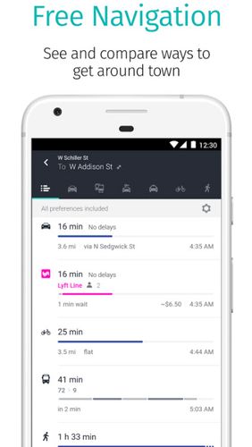
Big choice of transport
Comparison of routes
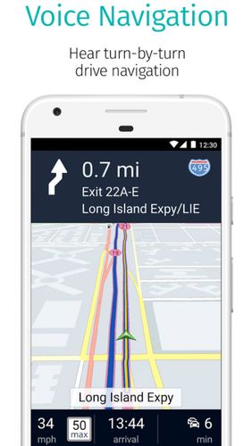
Voice and visual instructions
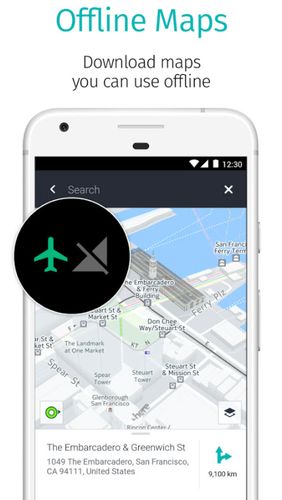
Offline maps
Like it? Share with your friends!
Supported operating systems:
Google Android 10.x, Google Android 4.1, Google Android 4.2, Google Android 4.3, Google Android 4.4, Google Android 5.x, Google Android 6.x, Google Android 7.x, Google Android 8.x, Google Android 9.x
Similar Software:
amAze (LG) AmAze is a first of its kind free navigation and local search service. It is free to download and use and it contains wide coverage of maps including aerial photo in Europe, North America, Australia and parts of Asia and Africa
amAze (Samsung) AmAze is a first of its kind free navigation and local search service. It is free to download and use and it contains wide coverage of maps including aerial photo in Europe, North America, Australia and parts of Asia and Africa
Navigator Navigator - detailed maps with the support of satellite navigation. You need to specify two points to make a route. You can track your current location and set those coordinates as the route start. Thanks to marks on the map you can easily find a fuel station, restaurant or hotel
Sensorly Map Viewer Sensorly Map Viewer - How good is your cell/mobile network coverage where you need it?
Is your favorite WiFi network going to be available at your vacation spot?
See the answer with this application and join us to build worldwide coverage maps.
(Data collection is configurable and can be turned off
OS Map OS Map is a tool to turn your Android phone into a handy Ordnance Survey map, with your GPS position pinpointed on it!
· Nearly all OS Map scales available (including 250,000 and 50,000).
· Touch-scrolling - simply use your finger to drag the map around.
· Fast resume from standby and fast position updates
amAze (LG) AmAze is a first of its kind free navigation and local search service. It is free to download and use and it contains wide coverage of maps including aerial photo in Europe, North America, Australia and parts of Asia and Africa
ShareYourDrive ShareYourDrive Transportation and cars especially are contaminating. Imagine with a few clicks, you can know who can give you a ride. The time real geolocalisation to save environment. Don't be afraid about security. Historic helps to know who was with you, when and where. Moreover you can give a rate to the persons you meet
Trapster Trapster- Your mobile phone alerts you as you approach police speed traps, red light and speed cameras, via spoken warnings in fun voices! Join world''s largest driver''s social network, 5 million users and growing! Drivers helping drivers! New for 1.6
MapMakr MapMakr If you’re an aid worker responding to a humanitarian crisis, up to date, accurate, and easy to read maps are vital. Knowing whether a bridge has collapsed, a road is passable and where you can land planes bringing in aid is really important


")
")


")

_13470small.png "Trapster")
