Outdoor Share for Android - The Outdoor Navigation software is your best friend through your adventures in the wild.
Go into the outdoors with confidence and enjoy your activities without worrying about the tools to help you navigate. Your Outdoor Navigation app is made by the people who have been developing this software since 2003 across multiple platforms. Be sure that you will stay ahead of the rest with continuous updates and relevant tools.
It is an excellent tool for biking, jogging, skiing, hiking, geocaching, boating, flying and many other sporting activities.
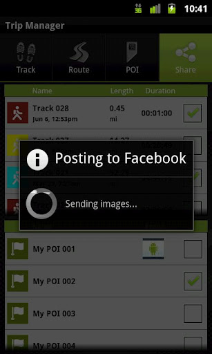
Your Outdoor Share will give you the ability to take those valuable tracks and POIs that you have created with your Outdoor Navigation base application and share them with your Facebook pals by uploading them to your Facebook account.
· Allows to share tracks and POIs with Facebook (besides the sharing via mail that is available also in the base version)
Installation instructions:
Outdoor Share is an add-on for the free Outdoor Navigation application. You need to have your Outdoor Navigation installed to be able to use Outdoor Share.
Download and install Outdoor Share on your Android device. Start the Outdoor Share plugin to complete the license checking: when activation will be completed then the icon will be removed (you need to restart your device to hide the icon) and the plugin will be used inside Outdoor Navigation application.
What's New in This Release:
· Bug fixing
Like it? Share with your friends!
Supported operating systems:
Google Android 10.x, Google Android 2.1, Google Android 2.2, Google Android 2.3, Google Android 3.0, Google Android 3.1, Google Android 3.2, Google Android 4.0, Google Android 4.1, Google Android 4.2, Google Android 4.3, Google Android 4.4, Google Android 5.x, Google Android 6.x, Google Android 7.x, Google Android 8.x, Google Android 9.x
Similar Software:
Pocket Caddy Pocket Caddy - #1 Golf GPS app: 3D flyover of holes, yardage to greens, shot recording, stats, scorecard, hazard carry or lay up position. Positioning is shot to hole, not cart to hole. Free PC Analytics inc. 3D Google Earth replay with stats, and Free DIY Course Mapping software both available from www.satsportsna
MapMyHike+ for Android MapMyHike+ for Android - MapMyHike is a mobile assistant designed to allow hikers to track their activities using their phone's built-in GPS.
With the app you can view your route on a map and record your trip details, including duration, distance, pace, speed and elevation.
You can also share the details of your activity with friends via Facebook, Twitter or email
Car Tracking Solutions Car Tracking Solutions is a provider of GPS Tracking and Vehicle Management. We provide a 24/7 monitoring service with operators standing by to assist you. We work hand on hand with the Royal Bahamas Police Force to assist with a quick response with vehicle recovery
Navitel Navigator Android “Navitel Navigator” is a unique and accurate navigation system. Detailed Russia map. Free traffic jams information service. SPEEDCAMs. The most detailed map of Russia: more than 118 000 cities and towns, 1500 of them contain address search information. The most detailed Moscow and Saint-Petersburg map
PlaceMemo Lite PlaceMemo Lite - One click to mark your favorite place like:
- parking lot to find your car
- restaurants
- theaters
- public park
...
One click to view locations in Google Map & get direction to it by GPS.
Email place(s), Weather of recorded place(s)..
Speedometer GPS HD Speedometer GPS HD - Speedometer GPS HD can display more info on one screen.
Speedometer GPS HD can track your speed,distance,time,location and also can get start time,time elapased,avg speed,max speed,altitude...
Features included
- Save your track info,Record gpx file(it will be saved in "sdcard/SpeedometerGPSHD/gpx/")
CoPilot Live Europe (Android) CoPilot Live Europe (Android) - CoPilot Live is full-featured voice-guided GPS navigation with Western and Eastern Europe street maps stored on your phone. Includes 3D guidance, lane assist, speed limit warnings, safety camera alerts, planning mode.
Download maps via WiFi after purchase. Unlimited use after 10 days once Google order verified
ParkLeitSystem ParkLeitSystem is a car-park-routing system. It shows you, according to your GPS position, the nearest city with a car-park-routing system and gives you a list with all available car-parkings and shows how many free places there are. With a click on the parking it switches to google maps and shows you the position of the parking
Live Tracker With Live Tracker the location of your Android phone can be tracked in real-time using a web browser. You can send an invitation email to selected contacts containing the link to track your location. Live Tracker provides continuous feedback about the number of web browsers tracking your location
Outdoor Chart for Android Outdoor Chart for Android - The Outdoor Navigation software is your best friend through your adventures in the wild.
Go into the outdoors with confidence and enjoy your activities without worrying about the tools to help you navigate. Your Outdoor Navigation app is made by the people who have been developing this software since 2003 across multiple platforms
Outdoor SOS for Android Outdoor SOS for Android - The Outdoor Navigation software is your best friend through your adventures in the wild.
Go into the outdoors with confidence and enjoy your activities without worrying about the tools to help you navigate. Your Outdoor Navigation app is made by the people who have been developing this software since 2003 across multiple platforms
Outdoor Navigation Pro for Android Outdoor Navigation Pro for Android - The Outdoor Navigation software is your best friend through your adventures in the wild.
Go into the outdoors with confidence and enjoy your activities without worrying about the tools to help you navigate. Your Outdoor Navigation app is made by the people who have been developing this software since 2003 across multiple platforms
GPS Tuner Essentials Full Version with BENELUX Basic Map Content GPS Tuner Essentials Full Version with BENELUX Basic Map Content is designed specifically for off-road use: its large buttons, selectable tool window size, multiple Compass views and the built-in Tele Atlas map makes it extremely user-friendly and reliable
GPS Tuner Atlas Full Version with Asia Pacific Basic Map Content GPS Tuner Atlas Full Version with Asia Pacific Basic Map Content is designed specifically for off-road use: its large buttons, selectable tool window size, multiple Compass views and the built-in Tele Atlas map makes it extremely user-friendly and reliable
Outdoor Offline Maps for Android Outdoor Offline Maps for Android - The Outdoor Navigation software is your best friend through your adventures in the wild.
Go into the outdoors with confidence and enjoy your activities without worrying about the tools to help you navigate. Your Outdoor Navigation app is made by the people who have been developing this software since 2003 across multiple platforms
GPS Tuner Essentials Full Version with Canada Basic Map Content GPS Tuner Essentials Full Version with Canada Basic Map Content is designed specifically for off-road use: its large buttons, selectable tool window size, multiple Compass views and the built-in Tele Atlas map makes it extremely user-friendly and reliable
GPS Tuner Essentials Full Version with Nordic Countries Basic Map Content GPS Tuner Essentials Full Version with Nordic Countries Basic Map Content is designed specifically for off-road use: its large buttons, selectable tool window size, multiple Compass views and the built-in Tele Atlas map makes it extremely user-friendly and reliable
US Terrain Intelligence for Android US Terrain Intelligence for Android - The Outdoor Navigation software is your best friend through your adventures in the wild.
Go into the outdoors with confidence and enjoy your activities without worrying about the tools to help you navigate. Your Outdoor Navigation app is made by the people who have been developing this software since 2003 across multiple platforms
GPS Tuner Essentials Full Version with Italy and Malta Basic Map Content GPS Tuner Essentials Full Version with Italy and Malta Basic Map Content is designed specifically for off-road use: its large buttons, selectable tool window size, multiple Compass views and the built-in Tele Atlas map makes it extremely user-friendly and reliable


")


