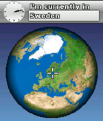
Wayfinder Earth (Pocket PC) - The world in your hand! Welcome to the ultimate experience of discovering the earth on your mobile phone, for free…
How does it all work?
It's simple. Wayfinder Earth presents you with a 3D globe representing the planet earth, visible on the display of your mobile phone. You are able to spin the globe manually, selecting an area or city, and zoom in for a closer look. The maps of Europe and North America are detailed and you can easily zoom to street level, making any tourist map obsolete.
Thanks to Wayfinder's technology maps of the world are constantly updated and occupy limited memory space on your mobile phone. Additionally, Wayfinder Earth includes more than three million Points of Interest (POIs), such as restaurants, train stations, bars, museums, gas stations or hospitals represented as icons on the maps of Europe and North America. Simply click on an icon and get instant interactive information such as addresses, opening hours, phone numbers and more.
Together with MyWayfinder.com, the on-line route planning tool to plan your journeys, you can find POIs and share destinations with friends and family.
Like it? Share with your friends!
If you got an error while installing Themes, Software or Games, please, read FAQ.
Supported operating systems:
Windows Mobile 2003, Windows Mobile 5.0, Windows Mobile 6 Classic, Windows Mobile 6 Professional, Windows Mobile 6.1 Classic, Windows Mobile 6.1 Professional, Windows Mobile 6.5 Professional
Similar Software:
Map of Milan / Italy for City Advisor Milan / Italy map for City Advisor. Includes all tube lines, all urban trains lines, all tramway lines, all bus lines and supports full timetables.
Instructions:
1. Download the map (zip file)
2. Extract the files in /CityAdvisor/maps
3. Open CityAdvisor -> Maps icon -> Menu -> Refresh
4
Travel Milan, Italy - illustrated travel guide, phrasebook, and maps Travel Milan, Italy - illustrated travel guide, phrasebook, and maps - An illustrated city guide, phrasebook, and maps. Indulge Yourself with a personal tour guide on Your PDA. FREE General Info, basic phrasebook and a map in the trial version.
Features
Fully illustrated.
Historical overviews.
Interesting facts
Tube London City Streets (2009 Edition) Tube London City Streets
This Tube package consists of a fully scrollable detailed map of the London Underground system and 9 linked GPS enabled A-Z street maps.
Plan journeys on the London Underground system, list details of the quickest routes and see a superb animated display of your journey tracking around the system map
MetrO Pocket PC Metro finds your way in public transport systems in more than 350 cities around the world (Paris, New York, London, Tokyo, any city with a subway & many more!).
FREE, FAST & ACCURATE
redBANG Shenzhen Map-Guide NEW 2006 THE BEST MOBILE GRAPHICS YOU HAVE EVER SET YOUR EYES ON
This City map-Guide contains all THE TOP locations at your finger tips. Simple and easy to use, simply zoom in & out of this jpg map or move N, E, S or West
Map of Peru Map of Peru - A map of Peru. Good for intercity travels with SmartMap.
Layers include:
Towns
Settlements
Airports
Roads
Railroads
Rivers
Inland water
Administrative borders
International borders
Trees
Map scale is 1:1 million.
Good for use with any version of SmartMap. SmartMap can be purchased here
Oxford Pocket A-Z map Oxford Pocket A-Z map - This publication has been designed for a Pocket PC running Windows® Mobile-based Pocket PC (version 2002 or later) and the Pocket A-Z Viewer (included). The map covers an area of central Oxford, extending to Summertown, Blackbird Leys, Kennington and New Botley
Map of Nevada (US State) Map of Nevada (US State) - A map of the Nevada by VITO Technology. Good for intercity travels with SmartMap.
SmartMap is a mobile device application which uses vector and raster maps. It is compatible with any NMEA protocol GPS receiver (Compact Flash socket, serial port, BlueTooth or sleeve)
Leicester Pocket A-Z Map Leicester Pocket A-Z Map - This publication has been designed for a Windows® Mobile-based Pocket PC (version 2002 or later) and the Pocket A-Z Viewer (included). The map covers an area of Leicester, extending to Anstey, Cropston, Rothley station, Syston, Scraptoft, Oadby, Wigston, Blaby, Narborough, Leicester Forest East, and Groby (part)
MetroMap Metro map (Moscow, St. Petersburg, Minsk, Kiev, Ekaterinburg, Nizhny Novgorod, Novosibirsk, Samara
Other Software by developer «Wayfinder Systems»:
Wayfinder Navigator (UIQ) Wayfinder Navigator (UIQ) - transform your mobile phone to something more useful than the ordinary GPS. With millions of points of interest and even social networking features you have a real guide that you can take with you everywhere - wherever you travel in your everyday life
Wayfinder Earth (Java) Wayfinder Earth (Java) - The world in your hand! Welcome to the ultimate experience of discovering the earth on your mobile phone, for free.
How does it all work?
It is simple. Wayfinder Earth presents you with a 3D globe representing the planet earth, visible on the display of your mobile phone
Wayfinder Navigator (BlackBerry) Wayfinder Navigator (BlackBerry) - Wayfinder Navigator online and a GPS receiver transform your mobile device to something more useful than the ordinary GPS. With millions of points of interest and even social networking features you have a real guide that you can take with you everywhere - wherever you travel in your everyday life
Wayfinder SpeedAlert Wayfinder SpeedAlert gives you speed camera warnings and speed alerts in your mobile with over 22.000 speed cameras in 22 countries
Wayfinder Earth (S60 3rd Edition) Wayfinder Earth (S60 3rd Edition) - The world in your hand! Welcome to the ultimate experience of discovering the earth on your mobile phone, for free.
How does it all work?
It's simple. Wayfinder Earth presents you with a 3D globe representing the planet earth, visible on the display of your mobile phone
Wayfinder Earth (UIQ) Wayfinder Earth (UIQ) - The world in your hand! Welcome to the ultimate experience of discovering the earth on your mobile phone, for free.
How does it all work?
It's simple. Wayfinder Earth presents you with a 3D globe representing the planet earth, visible on the display of your mobile phone
Wayfinder Active (Java) Wayfinder Active (Java) is a free GPS service for mobile phones with a unique combination of maps, GPS recording and statistics, all designed for active people. With this service on your mobile, you get access to a world wide map and terrain maps for selected countries.
You record your route or training trail with just a click
Wayfinder Navigator Wayfinder Navigator transform your mobile phone to something more useful than the ordinary GPS. With millions of points of interest and even social networking features you have a real guide that you can take with you everywhere - wherever you travel in your everyday life
Wayfinder Earth (S60 2nd Edition) Wayfinder Earth (S60 2nd Edition) - The world in your hand! Welcome to the ultimate experience of discovering the earth on your mobile phone, for free.
How does it all work?
It's simple. Wayfinder Earth presents you with a 3D globe representing the planet earth, visible on the display of your mobile phone


")
")


")


")


")
")
")

")
")
")

")