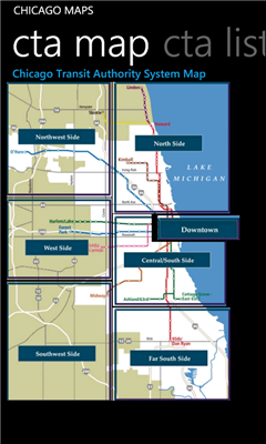
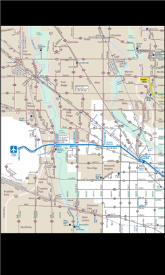
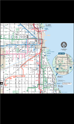
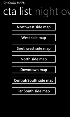
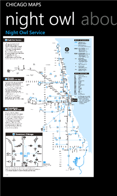
Chicago Maps - Offline (no data connection necessary!) public transportation maps for the Chicago area. Click on the thumbnails and zoom in for a detailed look.
Includes:
1. an overview of the Chicago Transit Authority system with the ability to zoom into different sections using a map and/or a list
2. Night Owl bus map
Can be used in portrait or landscape view.
Like it? Share with your friends!
If you got an error while installing Themes, Software or Games, please, read FAQ.
Supported operating systems:
Windows 10 Mobile, Windows Phone 7, Windows Phone 8
Similar Software:
Mymaps Mymaps - This is an extra odinary app which collaborates bing maps with gmaps or google maps...just browse on bing with the experience of google maps.
This application is a cross between gmaps and bing maps...
lets call it gingmaps :-p
Cheers and please do review
Metro Paris Simple et efficace, le plan de metro de Paris toujours dans votre poche grace a cette application
MapStalt Mini MapStalt Mini is an application that is meant to bring the map to completeness. In the case of the open street map, many details are missing, and MapStalt puts to power to complete the map into the hands of the mobile user. With MapStalt, a user can add something as simple as a building address and latitude/longitude or complex details such as business hours of operation
You Are Here You are lost and don't have a GPS? Don't worry, this application always shows you where you are, with a precision of 50 centimeters!
Washington SR 520 Toll & Traffic Washington SR 520 Toll & Traffic - Electronic tolling on SR 520 will begin this spring. Be ready by checking how much it will cost you to cross SR 520. Application takes in account US Holidays and provides additional information, such as current crossing time for both directions, and traffic map of the bridges
Googlemaps Googlemaps - Enjoy Almost all features of Google Maps on your WindowsPhone7
Enjoy The Water-overlay mode, Physical mode, Hybrid mode, Satellite View, Street-View.
You can zoom in and zoom out without any Hindrance
Map Services This application let the user to view maps, trace routes between two places, find a place, query for the weather in the current map position
Find My Car Find My Car Have you every parked your car and then went about your day, only to realize at the end of the day that you don't recall where you parked it? Then "Find My Car" is for you.
What's New in This Release:
· Updated to support copy and paste functionality and update Bing maps
A-Z London Visitors A-Z London Visitors - Visiting London? Download A-Z's handy free London Visitors' Map. The map provides a quick and simple overview of the major places of interest in London.
For more detailed mapping covering a much greater area, please see our full A-Z of London app (search Marketplace for A-Z London)
ArcGIS ArcGIS is a great way to discover and use maps. Tap on the map or use your current location to discover information about what you see. Search and find interesting information in the map as well as measure distances and areas. Find community hosted maps from ArcGIS Online, ESRI's online GIS, or use the authoring tools on ArcGIS
Other Software by developer «Pegus Co»:
Austin Facts Austin Facts - Austin Facts app features information about Austin, Texas in the following 11 sections:
1. About Austin, Texas
2. History
3. Geography
4. Climate
5. Demographics
6. Economy
7. Attractions
8. Sports
9. Government
10. Education
11
3-2-1 Math Bet! Free 3-2-1 Math Bet! Free - One of the main features allows you to set how many score points you want to risk in each round
Los Angeles Facts Los Angeles Facts - Los Angeles Facts app features information about Los Angeles, CA in the following 12 sections:
1. About New York City
2. Geography
3. Climate
4. Landmarks
5. City sections
6. Culture
7. Education
8. Media
9. Sports
10. Economy
11. Demographics
12
2 Players Math 2 Players Math - Practice multiplication with your kids! This free app will make your kids crazy about multiplication table! Your kids will excell at school!
2 Players Math pits two opponents on one phone against each other in a race to see whose math brain is the fastest.
Choose to compete in addition or multiplication of 1- 2- or 3-digit numbers
Cambridge Facts Cambridge Facts - Cambridge Facts app features information about Cambridge, MA in the following 10 sections:
1. About Cambridge, MA
2. Geography
3. Parks
4. Government
5. Culture
6. Education
7. Media
8. Economy
9. Demographics
10
Fort Worth Facts Fort Worth Facts - Fort Worth Facts app features information about Fort Worth, Texas in the following 11 sections:
1. About Fort Worth
2. History
3. Geography
4. Climate
5. Demographics
6. Economy
7. Attractions
8. Sports
9. Government
10. Education
11
Philadelphia Maps Philadelphia Maps - Ad-free, offline (no data connection necessary after first download) public transportation maps for the Philadelphia area.
Includes:
subway
commuter rail
trolleys
Can be used in portrait or landscape view
Dallas Facts Dallas Facts - Dallas Facts app features information about Dallas, Texas in the following 11 sections:
1. About San Diego
2. History
3. Geography
4. Climate
5. Demographics
6. Economy
7. Attractions
8. Sports
9. Government
10. Education
11
Chicago Facts Chicago Facts features information about Chicago, IL in the following 14 sections:
1. About Chicago
2. Geography
3. Climate
4. Architecture
5. City sections
6. Entertainment
7. Tourism
8. Parks
9. Cuisine
10. Religion
11. Sports
12. Economy
13. Demographics
14
Phoenix Facts Phoenix Facts app features information about Phoenix, AZ in the following 12 sections:
1. About Phoenix
2. Geography
3. Climate
4. Cityscape
5. Government
6. Culture
7. Education
8. Media
9. Sports
10. Economy
11. Demographics
12