Marine : USA All (West, East, Great Lakes, Rivers) - Water Map Navigator
Version: 2.5.1
Platforms: iPhone, iPad, iPod Touch, Apple iPhone OS
Categories: Travel & Navigation
Upload date: 28 Jun 11
Developer: Flytomap
License: Commercial
Price: 7.99 $
Downloads: 24
Marine : USA All (West, East, Great Lakes, Rivers) - Water Map Navigator - FlytoMap provides complete, quick and easy to use map applications for navigation for iPhone. Continues in the tradition of offering depth of information and functionality across expected places all over the world, exploring the map you get maximum details obtaining detailed information of every object on the map.
FlytoMap processes different types of maps for navigation for different categories:
WATER MAPS (Marine):
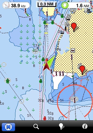
Water map navigator is the new ‘Marine Navigator for iPhone’ contains embedded Electronic Nautical Charts (ENC) from NOAA compressed to a large coverage. You can now download the application and transform your iPhone in a chart plotter with best NOAA, ENC S57 cartography; which includes Anchoring areas, Fishing areas, restriction areas, obstructions, rocks, Buoys, Beacons, Lights, Depth contours with Values display on map, Spot Soundings and more. The only marine app available in the market with such huge information. Every effort is made to be as accurate as possible when presenting information for every destination.
PARK MAPS:
Park map applications are extremely advanced contains embedded electronic charts with all information collected from the National Park Service and local sources. The maps contain all multiple trails (Hiking, biking, Stairway trails, Bicycle trails, Equestrian trails etc.,) and Point of interests (POI) like Campgrounds, Eating places, Ranger Stations, Picnic areas, Boat/Canoe launching, Parking areas etc., which are provided depending on the relevant park areas they exist.
LAKE MAPS:
We offer high quality lake maps with detailed information and important features compressed to assure the larger coverage in USA region. Lake maps contain most important DNR lakes with detailed ‘Depth Contours, Boat Ramps, Fishing spots etc. Also includes Trails, Roads and Railways information.
TRAVEL MAPS:
These Maps treat you mostly with information of both Marine and terrain correspondingly. These are the most preferable Maps to travel especially for fascinating recreational voyages, map focus the best Beach spots along the Coast line, Major ports, Sailing, Fishing, Picnic areas, Parks, Hiking, Biking, Clubs, restaurants, Famous Hotels, Museums, Shopping areas, and much more.
· Use Latitudes and Longitudes to go to your favorite places
· Insert the target/destination 'Waypoint' and see in real time your speed, distance and direction to destination
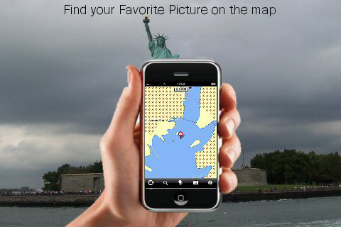
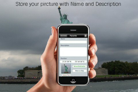
· Insert Unlimited Markers near favorite places on the map
· Search your Favorite points directly
· Zoom, Rotate and Pan fast just by a finger touch
· Navigate and see your GPS position on the map
· Geo-Tagged photo management
· Set On/Off Elevation Contours if you feel data is cluttering
What's New in This Release:
· Fully compatible to 4.0
· Improved GPS management in low signal conditions
· Added direction angle information when navigating toward a destination
Like it? Share with your friends!
If you got an error while installing Themes, Software or Games, please, read FAQ.
Supported operating systems:
Apple iOS 10.x (iPad), Apple iOS 10.x (iPhone), Apple iOS 11.x (iPad), Apple iOS 12.x (iPad), Apple iOS 12.x (iPhone), Apple iOS 4.0.x (iPhone), Apple iOS 4.0.x (iPod Touch), Apple iOS 4.2.x (iPad), Apple iOS 4.2.x (iPhone), Apple iOS 4.2.x (iPod Touch), Apple iOS 4.3.x (iPad), Apple iOS 4.3.x (iPhone), Apple iOS 4.3.x (iPod Touch), Apple iOS 5.0 (iPad), Apple iOS 5.0 (iPhone), Apple iOS 5.0 (iPod Touch), Apple iOS 6.0 (iPad), Apple iOS 6.0 (iPhone), Apple iOS 6.0 (iPod Touch), Apple iOS 7.0 (iPad), Apple iOS 7.0 (iPhone), Apple iOS 7.0 (iPod Touch), Apple iOS 8.x (iPad), Apple iOS 8.x (iPhone), Apple iOS 8.x (iPod Touch), Apple iOS 9.x (iPad), Apple iOS 9.x (iPhone), Apple iOS 9.x (iPod Touch), Apple iPhone OS 3.1.x, Apple iPhone OS 3.1.x (iPod Touch), Apple iPhone OS 3.2.x (iPad)
Similar Software:
Lancaster (CA,USA) Map Offline Lancaster (CA,USA) Map Offline - This will be perfect when you are traveling and you don't have internet connection. This Offline Maps is not a replacement of Google Maps. It is used when you don't have internet connection and want to use maps
Brugge Street Map Lite Brugge Street Map Lite - Lets you find all streets, and many useful locations such as ATM's, parkings, museums, and many others. Remembers where you've been so you can find that parking spot where you left your rental car
Santa Cruz Street Map Santa Cruz Street Map - Lets you find all streets, and many useful locations such as ATM's, parkings, museums, and many others. Remembers where you've been so you can find that parking spot where you left your rental car
Luxembourg City Offline Street Map Luxembourg City Offline Street Map - You don't need to have internet connection for this to work as the map is stored on your iPhone or iPod Touch. Ideal for saving roaming charges or having to find the local wifi to access the built-in map application.
What's New in This Release:
· iOS 5 compatibility changes.
· Further bug fixes and improvements
Vancouver Map and Walking Tours Vancouver Map and Walking Tours - No need to hop on a tour bus or join a group; now you can explore all the best attractions on your own, at your own pace, and at a cost that is only a fraction of what you would normally pay for a guided tour
Barcelona Map and Walking Tours Barcelona Map and Walking Tours - No need to hop on a tour bus or join a group; now you can explore all the best attractions on your own, at your own pace, and at a cost that is only a fraction of what you would normally pay for a guided tour
Aachen Street Map Aachen Street Map - Lets you find all streets, and many useful locations such as ATM's, parkings, museums, and many others. Remembers where you've been so you can find that parking spot where you left your rental car
Campbell(California) World Travel Campbell(California) World Travel - map with locate me function makes you free to move.
Background reading always accompanies you on your trip
High Definition Dominican Republic Atlas (Zoom) - GPS Travel Companion High Definition Dominican Republic Atlas (Zoom) - GPS Travel Companion - Each map can be amplified several times.
The special customized Atlas Guide can get information such as:
flags
maps
travel information
touristic top locations
history
currencies
trivia
humor
pictures
videos
museums information
restaurant information
accommodations / hotel
Other Software by developer «Flytomap»:
Marine: Alaska South West - GPS Map Navigator Marine: Alaska South West - GPS Map Navigator - FlytoMap provides complete, quick and easy to use map applications for navigation for iPhone. Continues in the tradition of offering depth of information and functionality across expected places all over the world, exploring the map you get maximum details obtaining detailed information of every object on the map
Marine: Nord Adriatico (Adriatic North) - GPS Map Navigator Marine: Nord Adriatico (Adriatic North) - GPS Map Navigator - FlytoMap provides Marine applications with complete, quick and easy to use map Interface for navigation for iPhone, exploring the map you get maximum details obtaining complete information of each point on the map
Canyonlands National Park - Standard Canyonlands National Park - Standard - Continues in the tradition of offering depth of information and functionality across expected places all over the world, exploring the map you get maximum details obtaining detailed information of each object on the map
Allegheny National Forest & CA - (Lakes&Marine) Allegheny National Forest & CA - (Lakes&Marine) - Continues in the tradition of offering depth of information and functionality across expected places all over the world, exploring the map you get maximum details obtaining detailed information of each object on the map
Ashton Court Estate - (Bristol) - GPS Map Navigator Ashton Court Estate - (Bristol) - GPS Map Navigator - Ashton Court Estate is a wonderful Historical location a must visit place situated in Bristol. It is surrounded by 840 acres having a mixture of woodland and open countryside. There are steep grassy slopes, plantations of native and patterned trees and a deer park
Channel Islands National Park - Standard Channel Islands National Park - Standard - Continues in the tradition of offering depth of information and functionality across expected places all over the world, exploring the map you get maximum details obtaining detailed information of each object on the map
Kellerwald-Edersee National Park - GPS Map Navigator Kellerwald-Edersee National Park - GPS Map Navigator - FlytoMap provides complete, quick and easy to use map applications for navigation for iPhone. Continues in the tradition of offering depth of information and functionality across expected places all over the world, exploring the map you get maximum details obtaining detailed information of every object on the map
Pantelleria-Linosa-Lampedusa - GPS Map Navigator Pantelleria-Linosa-Lampedusa - GPS Map Navigator - FlytoMap provides complete, quick and easy to use map applications for navigation. Continues in the tradition of offering depth of information and functionality across expected places all over the world, exploring the map you get maximum details obtaining detailed information of every object on the map
Crater Lake National Park - Standard Crater Lake National Park - Standard - Continues in the tradition of offering depth of information and functionality across expected places all over the world, exploring the map you get maximum details obtaining detailed information of each object on the map
Marine : Cote d'Azur - GPS Map Navigator Marine : Cote d'Azur - GPS Map Navigator - FlytoMap provides complete, quick and easy to use map applications for navigation for iPhone. Continues in the tradition of offering depth of information and functionality across expected places all over the world, exploring the map you get maximum details obtaining detailed information of every object on the map
Comments on Marine : USA All (West, East, Great Lakes, Rivers) - Water Map Navigator:
Comments not found
If you noted an error or download link is broken, please, report it via this page or use comments.
Marine : USA All (West, East, Great Lakes, Rivers) - Water Map Navigator is compatible with your device Apple iPod touch 4th Generation 8GB / 32GB / 64GB


 - Water Map Navigator")
 - Water Map Navigator")

 Map Offline")


 World Travel")
 - GPS Travel Companion")

 - GPS Map Navigator")

")
 - GPS Map Navigator")


