Platforms: iPhone, iPad, iPod Touch, Apple iPhone OS
Categories: Travel & Navigation
Upload date: 11 May 13
Developer: Visual IT
License: Commercial
Price: 1.99 $
Downloads: 22
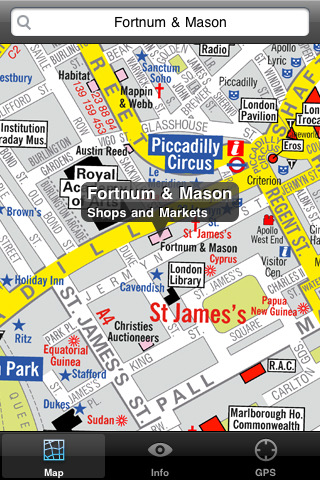
London Visitors A-Z - The London Visitors Map of central London is designed especially for the tourist. The principal feature of the mapping is the highlighting of places of interest, buildings open to the public, theatres, cinemas, selected shops and stores, main shopping streets, main line and underground railway stations and other locations of interest to the visitor. Road information shown includes A and B roads, bus routes and a selection of principal minor roads. This map is drawn by real cartographers with the detailed care and human touch of emphasis and colour that A-Z are famous for.
With the maps installed on your device there is never any need for an internet connection enabling you to access the map anywhere and at anytime. This application starts up instantly and can find any location on the map immediately. You can also use your inbuilt location services (GPS, Wifi, etc) to locate your position on the map.
Visual IT has partnered with the “Geographers A-Z Map Company” and negotiated a license to produce this map for iPhone, iPod Touch and iPad users at this very competitive price.
Add this map to one of our “Zuti” route planner maps (the classic “Zuti - London Underground” or the geographically based version “Zuti – London Tube” or if travelling by bus the “Zuti – London Bus”) and you are well equipped to travel anywhere in the central London area.
COVERAGE
The map covers an area extending from Charing Cross to:- St. John's Wood, Regent's Park, St. Pancras International Station, Shoreditch, Tower Bridge, Bermondsey, Newington, Westminster, Sloane Square, South Kensington, Earl's Court, Kensington High Street, Bayswater and Maida Vale.
What's New in This Release:
· Updated for iPhone 5 display
· Now a universal app that runs on iPhone and iPad
What's New in 1.3:
· Latest map and data.
· Minor bug fixes.
What's New in 1.2:
· Added the ability to markup the map with points, routes and areas of interest
Like it? Share with your friends!
If you got an error while installing Themes, Software or Games, please, read FAQ.
Supported operating systems:
Apple iOS 10.x (iPad), Apple iOS 10.x (iPhone), Apple iOS 11.x (iPad), Apple iOS 12.x (iPad), Apple iOS 12.x (iPhone), Apple iOS 4.0.x (iPhone), Apple iOS 4.0.x (iPod Touch), Apple iOS 4.2.x (iPad), Apple iOS 4.2.x (iPhone), Apple iOS 4.2.x (iPod Touch), Apple iOS 4.3.x (iPad), Apple iOS 4.3.x (iPhone), Apple iOS 4.3.x (iPod Touch), Apple iOS 5.0 (iPad), Apple iOS 5.0 (iPhone), Apple iOS 5.0 (iPod Touch), Apple iOS 6.0 (iPad), Apple iOS 6.0 (iPhone), Apple iOS 6.0 (iPod Touch), Apple iOS 7.0 (iPad), Apple iOS 7.0 (iPhone), Apple iOS 7.0 (iPod Touch), Apple iOS 8.x (iPad), Apple iOS 8.x (iPhone), Apple iOS 8.x (iPod Touch), Apple iOS 9.x (iPad), Apple iOS 9.x (iPhone), Apple iOS 9.x (iPod Touch), Apple iPhone OS 3.1.x, Apple iPhone OS 3.1.x (iPod Touch), Apple iPhone OS 3.2.x (iPad)
Similar Software:
Valencia Offline Street Map Valencia Offline Street Map - You don't need to have internet connection for this to work as the map is stored on your iPhone or iPod Touch. Ideal for saving roaming charges or having to find the local wifi to access the built-in map application.
What's New in This Release:
· iOS 5 compatibility changes.
· Further bug fixes and improvements
Avignon Street Map Avignon Street Map - Lets you find all streets, and many useful locations such as ATM's, parkings, museums, and many others. Remembers where you've been so you can find that parking spot where you left your rental car
Munich Offline Street Map Munich Offline Street Map - You don't need to have internet connection for this to work as the map is stored on your iPhone or iPod Touch. Ideal for saving roaming charges or having to find the local wifi to access the built-in map application.
What's New in This Release:
· iOS 5 compatibility changes.
· Further bug fixes and improvements
Cambridge Walking Tours and Map This application presents you several self-guided walking tours to see the best of the city, and it comes with detailed tour route maps and powerful navigation features to guide you from one sight to the next
High Definition Singapore Atlas (Zoom) - GPS Travel Companion High Definition Singapore Atlas (Zoom) - GPS Travel Companion - Each map can be amplified several times.
The special customized Atlas Guide can get information such as:
flags
maps
travel information
touristic top locations
history
currencies
trivia
humor
pictures
videos
museums information
restaurant information
accommodations / hotel
Australia Map Australia Map - This application enables you to use maps offline without internet connection. This includes maps street names detail. This will give peace of mind when traveling aboard knowing you will not be charged with roaming fee. So if you live or travel in that city, it will help you much in your life
High Definition Central America and the Caribbean Atlas (New Zoom) - HD Deluxe High Definition Central America and the Caribbean Atlas (New Zoom) - HD Deluxe - Each map can be amplified several times.
The special customized Atlas Guide can get information such as:
flags
maps
travel information
touristic top locations
history
currencies
trivia
humor
pictures
videos
museums information
restaurant information
accommodations / hotel
Los Angeles City Atlas (High Definition Zoom) * GPS Travel Companion USA Los Angeles City Atlas (High Definition Zoom) * GPS Travel Companion USA - Each map can be amplified several times.
The special customized Atlas Guide can get information such as:
flags
maps
travel information
touristic top locations
history
currencies
trivia
humor
pictures
videos
museums information
restaurant information
accommodations / hotel
Kitchener Maps Offline Kitchener Maps Offline - This will be perfect when you are traveling and you don't have internet connection. This Offline Maps is not a replacement of Google Maps. It is used when you don't have internet connection and want to use maps
Bratislava Street Map Bratislava Street Map - Lets you find all streets, and many useful locations such as ATM's, parkings, museums, and many others. Remembers where you've been so you can find that parking spot where you left your rental car
Other Software by developer «Visual IT»:
New York Subway 10 for iPad New York Subway 10 - The “New York Subway” application is a superb geographically based map and route planner for the New York public transport systems
Tube 2 Paris Touristic (UIQ3) Tube 2 Paris Touristic (UIQ3) - This map package for Tube 2 is the ideal map for the tourist or business traveller who needs to get around Paris using the metro system and would like to know just exactly where they are. The map geographically locates all the central stations, making it much more informative than the official topological map
Tube 2 Washington Pro (UIQ) Tube 2 Washington Pro (UIQ) - This map package for Tube 2 consists of a fully scrollable detailed map of the Washington D.C. metro system and linked high quality street maps of central Washington D.C.
Plan journeys on the metro system, list details of the quickest routes and see a superb animated display of your journey tracking around the system map
Tube Sydney (Series 60) Tube Sydney (Series 60) - Our highly acclaimed Tube application that guides you around the rail system of Sydney is now available for your Series 60 Symbian powered phone. An essential addition to your phone for locals and tourists alike.
· A detailed clear colour map of the Sydney rail system fully scrollable.
· Quick find station utility
London Central Bus 10 London Central Bus 10 - The new Zuti London Bus map has finally arrived, making it easy to travel by bus anywhere in central London. This clear and colourful map covers a detailed street level area of 6 miles by 4 miles and includes over 1300 bus stops and 189 bus routes
Tube 2 Tokyo (UIQ) Tube 2 Tokyo (UIQ) - This map package for Tube 2 consists of a fully scrollable detailed map of the Tokyo city subway & JR rail system
Tube 2 London Streets (Palm OS) Tube 2 London Streets (Palm OS) - This map package for Tube 2 consists of a fully scrollable detailed map of the London Underground system and 9 linked A-Z street maps.
Plan journeys on the London Underground system, list details of the quickest routes and see a superb animated display of your journey tracking around the system map
Tube 2 Munich (Palm OS) Tube 2 Munich (Palm OS) - This map package for Tube 2 consists of a fully scrollable detailed map of the Munich metro, rail & tram system.
Plan journeys on this system, list details of the quickest routes and see a superb animated display of your journey tracking around the system map.
Munich is the capital city of Bavaria, the southern most German federal state
Rome Metro for iPad by Zuti Rome Metro for iPad by Zuti - The Zuti Rome Metro application is a superb geographically based map and route planner for the Metro, Tram, Urban and Regional rail systems. Unlike old fashioned schematic style maps this product contains a geographically accurate central area showing major streets, parks and places of interest etc, allowing the user to easily get their bearings
London Central Bus 10 for iPad London Central Bus 10 for iPad - The new Zuti London Bus map has finally arrived, making it easy to travel by bus anywhere in central London. This clear and colourful map covers a detailed street level area of 6 miles by 4 miles and includes over 1300 bus stops and 189 bus routes


 - GPS Travel Companion")

 - HD Deluxe")
 * GPS Travel Companion USA")


")
")
")

")
")
")

