Platforms: iPhone, iPad, iPod Touch, Apple iPhone OS
Categories: Travel & Navigation
Upload date: 24 Apr 12
Developer: Garmin
License: Commercial
Price: 0.99 $
Downloads: 67
Garmin StreetPilot onDemand brings the power of Garmin navigation to your iPhone with rich navigation features for walking or driving, a simple and intuitive user interface, and an amazingly low price. Using your data connection, StreetPilot onDemand always has access to the most up-to-date maps for the U.S. and Canada so you can navigate with confidence whether you're on foot or in the car. Install the application while you're on-the-go and begin navigating in minutes.
StreetPilot onDemand includes 30 days of access to Premium Navigation with Traffic. After 30 days, you can still enjoy many navigation functions, or you can opt for a monthly or yearly subscription via in-app purchase. This subscription includes voice-guided navigation with automatic off-route recalculation, integrated real-time traffic, photoReal junction view, 3D buildings and landmarks, lane guidance, speed limits and more.
StreetPilot onDemand is loaded with pedestrian-friendly options. With an active subscription, StreetPilot onDemand gives you precise directions using all the available public transit options, with a detailed itinerary of transit stops and walking instructions, so you don’t spend your time waiting. Whether it’s by bus, subway, tram or train, you’ll navigate the big city like a local.
StreetPilot onDemand provides a wealth of premium benefits with an active subscription:
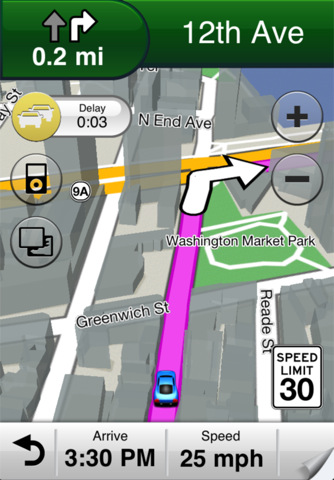
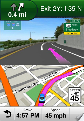
· Navigate in the car with voice-prompted, turn-by-turn directions including street names
· Access real-time traffic updates and see the estimated traffic delay along your route
· View speed limits for most major roads
· Know the correct lane before it’s too late with lane guidance and photoReal junction views
· Navigate while walking with routes that integrate public transportation into your itinerary
· See 3D buildings and landmarks for added awareness while navigating
Without a subscription, StreetPilot onDemand still offers many features:
· Get driving or walking directions to any destination and track your progress on the moving map
· Find new places to visit with suggestions based on your previous search history
· Have the latest maps for the U.S. and Canada, downloaded to your device on demand
· Browse maps you've recently viewed, even when outside of data coverage areas
· Look up points-of-interest (POIs) such as restaurants, gas stations, hotels and more with Google local search
· Navigate to contacts in your address book
· Show / hide POIs, favorites and suggestions on the map, including different POIs by category
· View weather conditions and forecasts
· Place calls directly from search listings
· Navigate in both portrait and landscape mode
· Pinch, pan, zoom, and rotate maps with full gesture support
· Listen to music while navigating with integrated iPod music controls
· Access other apps on your device while navigating with multi-tasking support
StreetPilot onDemand lets you access your subscription on multiple devices at no additional cost. You can conveniently manage your subscription through your iTunes account and cancel at any time.
Map coverage:
United States, Canada, Puerto Rico, U.S. Virgin Islands, Cayman Islands, The Bahamas, French Guiana, Guadeloupe, Martinique, Saint Barthélemy and Jamaica.
Public transit information is available in 31 metropolitan areas. Transit coverage varies by market.
Please note that continued use of GPS running in the background can dramatically decrease battery life.
What's New in This Release:
· Trip Computer provides interesting statistics about your drive. Just tap the speed field on the map page to see your details
· Minor bug fixes and performance improvements
What's New in 7.5.0:
· Keep in touch with your friends and explore your city with integrated Facebook, foursquare, and Wikipedia locations
· Check-In On Arrival feature makes it easy to post your location and status update to your favorite social network
· Create a personalized navigation experience by downloading free voices and vehicles from the Garmin Garage
· Trip Planner lets you plan before you travel, allowing you to create, edit, and save multiple routes
· Add multiple stops to your route while you're on the go with Via Points. Just look up a new destination, press Go, and add it to your active route
· Quickly modify your route to avoid unexpected roadblocks and emerging traffic conditions using the Detour feature
· Enhanced drawing of 3D buildings makes it even easier to gain situational awareness
Like it? Share with your friends!
If you got an error while installing Themes, Software or Games, please, read FAQ.
Supported operating systems:
Apple iOS 10.x (iPad), Apple iOS 10.x (iPhone), Apple iOS 11.x (iPad), Apple iOS 12.x (iPad), Apple iOS 12.x (iPhone), Apple iOS 4.0.x (iPhone), Apple iOS 4.0.x (iPod Touch), Apple iOS 4.2.x (iPad), Apple iOS 4.2.x (iPhone), Apple iOS 4.2.x (iPod Touch), Apple iOS 4.3.x (iPad), Apple iOS 4.3.x (iPhone), Apple iOS 4.3.x (iPod Touch), Apple iOS 5.0 (iPad), Apple iOS 5.0 (iPhone), Apple iOS 5.0 (iPod Touch), Apple iOS 6.0 (iPad), Apple iOS 6.0 (iPhone), Apple iOS 6.0 (iPod Touch), Apple iOS 7.0 (iPad), Apple iOS 7.0 (iPhone), Apple iOS 7.0 (iPod Touch), Apple iOS 8.x (iPad), Apple iOS 8.x (iPhone), Apple iOS 8.x (iPod Touch), Apple iOS 9.x (iPad), Apple iOS 9.x (iPhone), Apple iOS 9.x (iPod Touch), Apple iPhone OS 3.1.x, Apple iPhone OS 3.1.x (iPod Touch), Apple iPhone OS 3.2.x (iPad)
Similar Software:
CoPilot Live Premium HD Europe (iPhone/iPad) CoPilot Live Premium HD Europe (iPhone/iPad) - transforms your 3G iPad into an incredible large-screen in-car sat navigation system.
There's certainly no mistaking the route ahead. CoPilot Live takes full advantage of your iPad's screen to provide easy to follow, crystal clear guidance
Cabaneros National Park - GPS Map Navigator Cabaneros National Park - GPS Map Navigator - FlytoMap provides complete, quick and easy to use map applications for navigation for iPhone. Continues in the tradition of offering depth of information and functionality across expected places all over the world, exploring the map you get maximum details obtaining detailed information of every object on the map
Cevennes National Park - GPS Map Navigator Cevennes National Park - GPS Map Navigator - FlytoMap provides complete, quick and easy to use map applications for navigation for iPhone. Continues in the tradition of offering depth of information and functionality across expected places all over the world, exploring the map you get maximum details obtaining detailed information of every object on the map
Gothenburg GPS Guide The only thing we do, help you to move freely as an alien, by "Offline" & "GPS"
NAVIGON MobileNavigator US MyRegion West With NAVIGON MyRegion you can transform your iPhone into a fully functional mobile navigation system that is every bit as good as the multi-award-winning personal navigation devices from NAVIGON in terms of its user-friendliness and features
Sygic Morocco: GPS Navigation Sygic Morocco: GPS Navigation - Sygic Mobile Maps is the most complete turn-by-turn, voice guided navigation software.
The application does not require Internet connection to operate
Allentown (PA,USA) Map Offline Allentown (PA,USA) Map Offline - This will be perfect when you are traveling and you don't have internet connection. This Offline Maps is not a replacement of Google Maps. It is used when you don't have internet connection and want to use maps
Sherbrooke (Canada) Map Offline Sherbrooke (Canada) Map Offline - This will be perfect when you are traveling and you don't have internet connection. This Offline Maps is not a replacement of Google Maps. It is used when you don't have internet connection and want to use maps
India GPS India GPS is a professional Car, Bike and Pedestrian navigation system for iPhone and iPad. This system not only for Car navigation, but also for pedestrian.
· 2D and 3D navigation mode and map.
· The speed is very fast.
· Using vector map which owns small size and can zoom in any level.
· Elegant operations
Santander GPS Guide The only thing we do, help you to move freely as an alien, by "Offline" & "GPS"
Other Software by developer «Garmin»:
Garmin Mechanic Garmin Mechanic - Get insight into how your car is performing with the free Garmin Mechanic application. Use the Skidpad to measure lateral acceleration, and track your speed and distance using GPS.
Taking a trip? Garmin Mechanic tracks your trips and calculates total distance, average speed, and estimated mileage to help increase fuel savings
Garmin N. America Garmin N. America - Download Garmin StreetPilot Onboard and give your iPhone the best in GPS navigation...even when you don’t have cell coverage. Maps reside on your device, so you can look up addresses and millions of points-of-interest such as gas stations, restaurants and ATMs without needing wireless coverage
Garmin Thailand Garmin Thailand - Garmin StreetPilot is a powerful GPS navigation solution for iOS devices. It comes preloaded with the latest map of Thailand.
Garmin Street offers many useful features, such as turn-by-turn directions, photo-realistic junction views, 3D buildings, exit services, speed cameras, and more
BaseCamp Mobile BaseCamp Mobile - BaseCamp Mobile is a companion app for the Garmin fenix GPS watch. It allows you to wirelessly download data from your watch to the iPhone.
Downloaded data can be used to view routes and tracks on a map. Very useful for recording and reviewing your outdoor activities
Garmin UK & Ireland Garmin UK & Ireland - Download Garmin StreetPilot Onboard UK & Ireland and give your iPhone the best in GPS navigation... with free camera alerts, photoReal junction views, 3D buildings, and more
Garmin Voice Studio Garmin Voice Studio - Customize your Garmin-Asus phone with turn-by-turn voice directions from family and friends.
Easily create and edit Garmin navigation prompts in many languages on your phone. Share your voices with others with Garmin-Asus phones as well as Garmin nüvis.
It's a great way to add some more personality to your Android phone
Garmin Fit Garmin Fit - Turn your iPhone into a powerful training tool with the Garmin Fit application. See your current walking, running or cycling stats at one glance, or review and share them later thanks to automatic uploading to Garmin Connect. It even allows you select the perfect soundtrack for your workout
Garmin GTN Trainer Garmin GTN Trainer - The Garmin GTN 750 Trainer allows you to experience the pilot interface and provide an on-the-ground environment to learn the basic operation of the avionics
Garmin Mobile for BlackBerry Garmin Mobile for BlackBerry - Turn your BlackBerry into a savvy navigator with Garmin Mobile. Includes everything you need - maps, millions of POIs and easy-to-use navigation software.
Get Premium Map Data
With spoken turn-by-turn directions that speak street names and millions of points of interest (POIs), Garmin Mobile puts robust content right at your fingertips
Garmin Western Europe Download Garmin StreetPilot Western Europe and give your iPhone or iPad the best in GPS navigation with free safety camera alerts, photoReal junction views, 3D buildings and more


")


 Map Offline")
 Map Offline")


