Platforms: iPhone, iPad, iPod Touch, Apple iPhone OS
Categories: Travel & Navigation
Upload date: 9 Dec 11
Developer: Flytomap
License: Commercial
Price: 2.99 $
Downloads: 192
Phuket Island - GPS Map Navigator - FlytoMap provides complete, quick and easy to use map applications for navigation for iPhone. Continues in the tradition of offering depth of information and functionality across expected places all over the world, exploring the map you get maximum details obtaining detailed information of every object on the map.
FlytoMap processes different types of maps for navigation for different categories:
WATER MAPS (Marine):
Water map navigator is the new ‘Marine Navigator for iPhone’ contains embedded Electronic Nautical Charts (ENC) from NOAA compressed to a large coverage. You can now download the application and transform your iPhone in a chart plotter with best NOAA, ENC S57 cartography; which includes Anchoring areas, Fishing areas, restriction areas, obstructions, rocks, Buoys, Beacons, Lights, Depth contours with Values display on map, Spot Soundings and more. The only marine app available in the market with such huge information. Every effort is made to be as accurate as possible when presenting information for every destination.
PARK MAPS:
Park map applications are extremely advanced contains embedded electronic charts with all information collected from the National Park Service and local sources. The maps contain all multiple trails (Hiking, biking, Stairway trails, Bicycle trails, Equestrian trails etc.,) and Point of interests (POI) like Campgrounds, Eating places, Ranger Stations, Picnic areas, Boat/Canoe launching, Parking areas etc., which are provided depending on the relevant park areas they exist.
LAKE MAPS:
We offer high quality lake maps with detailed information and important features compressed to assure the larger coverage in USA region. Lake maps contain most important DNR lakes with detailed ‘Depth Contours, Boat Ramps, Fishing spots etc. Also includes Trails, Roads and Railways information.
TRAVEL MAPS:
These Maps treat you mostly with information of both Marine and terrain correspondingly. These are the most preferable Maps to travel especially for fascinating recreational voyages, map focus the best Beach spots along the Coast line, Major ports, Sailing, Fishing, Picnic areas, Parks, Hiking, Biking, Clubs, restaurants, Famous Hotels, Museums, Shopping areas, and much more.
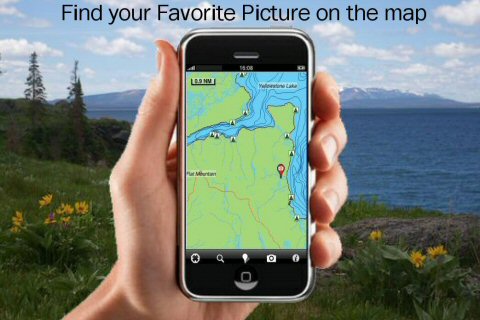
· Use Latitudes and Longitudes to go to your favorite places
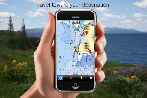
· Insert the target/destination 'Waypoint' and see in real time your speed, distance and direction to destination
· Insert Unlimited Markers near favorite places on the map
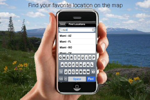
· Search your Favorite points directly
· Zoom, Rotate and Pan fast just by a finger touch
· Navigate and see your GPS position on the map
· Geo-Tagged photo management
· Set On/Off Elevation Contours if you feel data is cluttering
What's New in This Release:
· Added the link to the NOAA buoys in the application console.
What's New in 2.6:
· Minor bug fixed
· Retina display management
Like it? Share with your friends!
If you got an error while installing Themes, Software or Games, please, read FAQ.
Supported operating systems:
Apple iOS 10.x (iPad), Apple iOS 10.x (iPhone), Apple iOS 11.x (iPad), Apple iOS 12.x (iPad), Apple iOS 12.x (iPhone), Apple iOS 4.2.x (iPad), Apple iOS 4.2.x (iPhone), Apple iOS 4.2.x (iPod Touch), Apple iOS 4.3.x (iPad), Apple iOS 4.3.x (iPhone), Apple iOS 4.3.x (iPod Touch), Apple iOS 5.0 (iPad), Apple iOS 5.0 (iPhone), Apple iOS 5.0 (iPod Touch), Apple iOS 6.0 (iPad), Apple iOS 6.0 (iPhone), Apple iOS 6.0 (iPod Touch), Apple iOS 7.0 (iPad), Apple iOS 7.0 (iPhone), Apple iOS 7.0 (iPod Touch), Apple iOS 8.x (iPad), Apple iOS 8.x (iPhone), Apple iOS 8.x (iPod Touch), Apple iOS 9.x (iPad), Apple iOS 9.x (iPhone), Apple iOS 9.x (iPod Touch)
Similar Software:
Bregenz Map Offline Bregenz Map Offline - This will be perfect when you are traveling and you don't have internet connection. This Offline Maps is not a replacement of Google Maps. It is used when you don't have internet connection and want to use maps
Hunting Map - Colorado Hunting Map - Colorado - iHunt - Colorado is the best hunting map product available today on the market.
You can Navigate in real time looking your position on the map, you don't need internet connection, switch off the 3G and double your iPhone battery life.
It is a collection of the best hunting maps available for Colorado
Bath Street Map Bath Street Map - Lets you find all streets, and many useful locations such as ATM's, parkings, museums, and many others. Remembers where you've been so you can find that parking spot where you left your rental car. To make sure your phone doesn't use any expensive data on your trip, go to Settings, then General, tap on Network, and slide the Data Roaming to "off"
Cape Cod National Seashore - GPS Map Navigator Cape Cod National Seashore - GPS Map Navigator - Continues in the tradition of offering depth of information and functionality across expected places all over the world, exploring the map you get maximum details obtaining detailed information of each object on the map
Lubeck Street Map Lubeck Street Map - Lets you find all streets, and many useful locations such as ATM's, parkings, museums, and many others. Remembers where you've been so you can find that parking spot where you left your rental car
Augsburg (Germany) Map Offline Augsburg (Germany) Map Offline - This will be perfect when you are traveling and you don't have internet connection. This Offline Maps is not a replacement of Google Maps. It is used when you don't have internet connection and want to use maps
Eugene (OR, USA) Maps Offline Eugene (OR, USA) Maps Offline - This will be perfect when you are traveling and you don't have internet connection. This Offline Maps is not a replacement of Google Maps. It is used when you don't have internet connection and want to use maps
Moscow Travel Guide - Lonely Planet Comprehensive maps ensure you're never lost in this vast cultural playground; detailed history, culture and language chapters give you an essential entree to local life and independent, in-depth research means you'll never need to second guess
Audi Las Vegas Navigator Audi Las Vegas Navigator transforms your iPhone into a fully functional mobile navigation helping you to find your way to the 2011 International CES in Las Vegas. The application uses NAVIGON's award winning iPhone navigation software MobileNavigator and includes Nevada map material from the market leader NAVTEQ
Paris Maps Paris Maps - This super-handy app lets you download publicly available maps and store them on your iPhone or iPod Touch. You can download the maps when you have fast wifi connection - and then use any time in the future without delay. Metro, Bus, Train and Street maps, as well as tourist guides to help you around the city
Other Software by developer «Flytomap»:
Mount Ranier National Park - GPS Map Navigator Mount Ranier National Park - GPS Map Navigator - Continues in the tradition of offering depth of information and functionality across expected places all over the world, exploring the map you get maximum details obtaining detailed information of each object on the map
Angelina National Forest - GPS Map Navigator Angelina National Forest - GPS Map Navigator - FlytoMap provides complete, quick and easy to use map applications for navigation for iPhone. Continues in the tradition of offering depth of information and functionality across expected places all over the world, exploring the map you get maximum details obtaining detailed information of every object on the map
Marine: Adelaide HD - GPS Map Navigator Marine: Adelaide HD - GPS Map Navigator - FlytoMap provides complete, quick and easy to use map applications for navigation for iPad. Continues in the tradition of offering depth of information and functionality across expected places all over the world, exploring the map you get maximum details obtaining detailed information of every object on the map
Acadia National Park - GPS Map Navigator Acadia National Park - continues in the tradition of offering depth of information and functionality across expected places all over the world, exploring the map you get maximum details obtaining detailed information of each object on the map
Cuyahoga Valley National Park - GPS Map Navigator Cuyahoga Valley National Park - GPS Map Navigator - Continues in the tradition of offering depth of information and functionality across expected places all over the world, exploring the map you get maximum details obtaining detailed information of each object on the map
Lakes: Minnesota HD - GPS Map Navigator Lakes: Minnesota HD - GPS Map Navigator - FlytoMap provides complete, quick and easy to use map applications for navigation for iPad. Continues in the tradition of offering depth of information and functionality across expected places all over the world, exploring the map you get maximum details obtaining detailed information of every object on the map
Antigua - GPS Map Navigator Antigua - GPS Map Navigator - FlytoMap provides complete, quick and easy to use map applications for navigation for iPhone. Continues in the tradition of offering depth of information and functionality across expected places all over the world, exploring the map you get maximum details obtaining detailed information of every object on the map
Cairngorms National Park - GPS Map Navigator Cairngorms National Park - GPS Map Navigator - FlytoMap provides complete, quick and easy to use map applications for navigation for iPhone. Continues in the tradition of offering depth of information and functionality across expected places all over the world, exploring the map you get maximum details obtaining detailed information of every object on the map
Mesa Verde National Park - Standard Mesa Verde National Park - Standard - Continues in the tradition of offering depth of information and functionality across expected places all over the world, exploring the map you get maximum details obtaining detailed information of each object on the map
Ashton Court Estate - (Bristol) - GPS Map Navigator Ashton Court Estate - (Bristol) - GPS Map Navigator - Ashton Court Estate is a wonderful Historical location a must visit place situated in Bristol. It is surrounded by 840 acres having a mixture of woodland and open countryside. There are steep grassy slopes, plantations of native and patterned trees and a deer park

")


 Map Offline")
 Maps Offline")


 - GPS Map Navigator")