Platforms: iPhone, iPad, iPod Touch, Apple iPhone OS
Categories: Travel & Navigation
Upload date: 29 Oct 11
Developer: Visual IT
License: Commercial
Price: 9.99 $
Downloads: 16
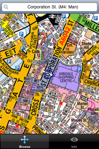
Manchester Mini A-Z - "Manchester Mini A-Z" is a digital rendition of the famous Geographers Company Mini A-Z Atlas for Manchester. This mini street atlas includes coverage of Kearsley, Whitefield, Middleton, Chadderton, Oldham, Walkden, Swinton, Prestwich, Failsworth, Worsley, Salford, Droylsden, Ashton-Under-Lyne, Eccles, Trafford Park, Salford, Dukinfield, Urmston, Stretford, Levenshulme, Reddish, Denton, Sale, Brinnington, Stockport, Wythenshawe, Cheadle and Manchester Airport.
The index section of the atlas lists: streets, walkways, places of interest, selected flats, place and area names plus National Rail and Metrolink stations. Also included is a listing of hospitals, hospices, and NHS Walk-in Centres that are covered by this atlas
This map is drawn by real cartographers with the detailed care and human touch of emphasis and colour that A-Z are famous for. Internet maps are OK but you really can’t beat the genuine article.
With the maps installed on your device there is never any need for an internet connection enabling you to access the map anywhere and at anytime. This application starts up in under 5 seconds and can find any location on the map in under 2 seconds. You can also use your inbuilt location services (GPS, Wifi, etc) to locate your position on the map.
Visual IT have partnered with the “Geographers A-Z Map Company” and negotiated a license to produce this map for iPhone or iPod Touch users at this very competitive price.
What's New in This Release:
· Support for retina display
· New "Measure Tool"
· Bug fix for the next iOS release
Like it? Share with your friends!
If you got an error while installing Themes, Software or Games, please, read FAQ.
Supported operating systems:
Apple iOS 10.x (iPad), Apple iOS 10.x (iPhone), Apple iOS 11.x (iPad), Apple iOS 12.x (iPad), Apple iOS 12.x (iPhone), Apple iOS 4.0.x (iPhone), Apple iOS 4.0.x (iPod Touch), Apple iOS 4.2.x (iPad), Apple iOS 4.2.x (iPhone), Apple iOS 4.2.x (iPod Touch), Apple iOS 4.3.x (iPad), Apple iOS 4.3.x (iPhone), Apple iOS 4.3.x (iPod Touch), Apple iOS 5.0 (iPad), Apple iOS 5.0 (iPhone), Apple iOS 5.0 (iPod Touch), Apple iOS 6.0 (iPad), Apple iOS 6.0 (iPhone), Apple iOS 6.0 (iPod Touch), Apple iOS 7.0 (iPad), Apple iOS 7.0 (iPhone), Apple iOS 7.0 (iPod Touch), Apple iOS 8.x (iPad), Apple iOS 8.x (iPhone), Apple iOS 8.x (iPod Touch), Apple iOS 9.x (iPad), Apple iOS 9.x (iPhone), Apple iOS 9.x (iPod Touch), Apple iPhone OS 3.1.x, Apple iPhone OS 3.1.x (iPod Touch), Apple iPhone OS 3.2.x (iPad)
Similar Software:
Ashton Court Estate - (Bristol) - GPS Map Navigator Ashton Court Estate - (Bristol) - GPS Map Navigator - Ashton Court Estate is a wonderful Historical location a must visit place situated in Bristol. It is surrounded by 840 acres having a mixture of woodland and open countryside. There are steep grassy slopes, plantations of native and patterned trees and a deer park
Colorado Springs Maps Offline Colorado Springs Maps Offline - This will be perfect when you are traveling and you don't have internet connection. This Offline Maps is not a replacement of Google Maps. It is used when you don't have internet connection and want to use maps
Dearborn(Michigan) World Travel Dearborn(Michigan) World Travel - Map with locate me function makes you free to move.
Background reading always accompanies you on your trip
Ocala National Forest - GPS Map Navigator Ocala National Forest - GPS Map Navigator - FlytoMap provides complete, quick and easy to use map applications for navigation for iPhone. Continues in the tradition of offering depth of information and functionality across expected places all over the world, exploring the map you get maximum details obtaining detailed information of every object on the map
Audi Las Vegas Navigator Audi Las Vegas Navigator transforms your iPhone into a fully functional mobile navigation helping you to find your way to the 2011 International CES in Las Vegas. The application uses NAVIGON's award winning iPhone navigation software MobileNavigator and includes Nevada map material from the market leader NAVTEQ
Rome Map and Walking Tours Rome Map and Walking Tours - No need to hop on a tour bus or join a group; now you can explore all the best attractions on your own, at your own pace, and at a cost that is only a fraction of what you would normally pay for a guided tour
Marine: Gargano - GPS Map Navigator Marine: Gargano - GPS Map Navigator - Flytomap offers revolutionary Marine applications for iPhone, iPod Touch & iPad!!!
Go boating in the wonderful Gargano waters - discovering the bays of Gargano is an unforgettable experience.
Gorgano Marine Map contains embedded Electronic Nautical charts compressed to a large coverage
Sherbrooke (Canada) Map Offline Sherbrooke (Canada) Map Offline - This will be perfect when you are traveling and you don't have internet connection. This Offline Maps is not a replacement of Google Maps. It is used when you don't have internet connection and want to use maps
Tube 2 Miami (UIQ3) Tube 2 Miami (UIQ3) - This map package for Tube 2 consists of a fully scrollable detailed map of the Miami metro & rail system.
Plan journeys on this system, list details of the quickest routes and see a superb animated display of your journey tracking around the system map
Tube Toronto Pro (Palm OS) Tube Toronto Pro (Palm OS) - This award winning and highly acclaimed Palm application that guides you around the subway system of Toronto now comes in a pro version with these extra features :
A superb full colour street level map of the central Toronto area with a find feature that enables you to quickly find any street, place of interest or station on the map
Tube 2 Brussels (UIQ3) Tube 2 Brussels (UIQ3) - This map package for Tube 2 consists of a fully scrollable detailed map of the Brussels tram, metro & bus system.
Plan journeys on these systems, list details of the quickest routes and see a superb animated display of your journey tracking around the system map
Tube 2 Dublin (UIQ) Tube 2 Dublin (UIQ) - This map package for Tube 2 consists of a fully scrollable detailed map of the Dublin rail system.
Plan journeys on this system, list details of the quickest routes and see a superb animated display of your journey tracking around the system map
Tube 2 New York Geo (Palm OS) Tube 2 New York Geo (Palm OS) - This superb map package for Tube 2 is the ideal map for anyone who needs to get around New York City using the MTA subway system and would like to know just exactly where they are.
The map geographically accurately locates all of Manhattans central stations, overlaid onto a street map
Tube 2 Seoul (UIQ3) Tube 2 Seoul (UIQ3) - This map package for Tube 2 consists of a fully scrollable detailed map of the Seoul Metropolitan Subway system.
Plan journeys on this system, list details of the quickest routes and see a superb animated display of your journey tracking around the system map
London Bus London Bus - The new Zuti London Bus map has finally arrived, making it easy to travel by bus anywhere in central London. This clear and colourful map covers a detailed street level area of 6 miles by 4 miles and includes over 1300 bus stops and 189 bus routes
Tube Toronto (UIQ) Tube Toronto (UIQ) - Our award winning and highly acclaimed application guides you around the subway system of Toronto is now available for your Symbian UIQ phone.
An essential addition to your P800 / P900 / P910 if you travel in or around this city
· A detailed clear colour map of the Toronto subway system fully scrollable.
· Quick find station utility
Tube 2 Berlin (UIQ) Tube 2 Berlin (UIQ) - This map package for Tube 2 consists of a fully scrollable detailed map of the Berlin Metro (U-Bahn/S-Bahn).
Plan journeys on this system, list details of the quickest routes and see a superb animated display of your journey tracking around the system map.
Berlin is the capital and largest city in Germany
Tube 2 Paris (Palm OS) Tube 2 Paris (Palm OS) - This map package for Tube 2 consists of a fully scrollable detailed map of the Paris metro and RER system.
Plan journeys on this system, list details of the quickest routes and see a superb animated display of your journey tracking around the system map.
A Pro version is also available with integrated high quality street maps of central Paris


 - GPS Map Navigator")

 World Travel")


 Map Offline")

")
")
")
")
")
")

")
")
")