Platforms: iPhone, iPad, iPod Touch, Apple iPhone OS
Categories: Travel & Navigation
Upload date: 6 Jul 11
Developer: Visual IT
License: Freeware
Downloads: 92
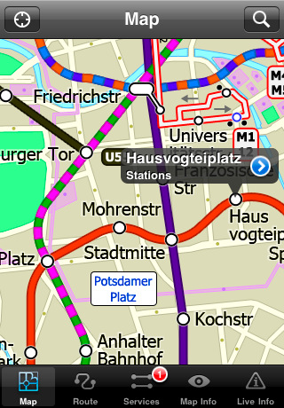
Berlin Metro by Zuti - The new Berlin Metro map makes it easy to travel in and around the city using the Metro (U-Bahn) Suburban Rail (S-Bahn) and Tram (MetroTram and Straßenbahn) systems. Unlike old fashioned schematic style maps this product contains a geographically accurate central area showing major streets, parks and places of interest etc, allowing the user to easily get their bearings.
MAP
The map is hand drawn by Visual IT and provides a unique geographically based view of Berlin with many places of interest drawn directly on the background so you can easily get your bearings when traveling around the city. You can also use your inbuilt GPS to accurately locate and track yourself within the city centre and see the nearest transportation stop and distance to it. This is the only public transportation route planner with this ability.
Tap on the map for location information, use the inbuilt search feature or choose from a list of locations. Places of interest, museums, hotels, parks, restaurant, shops, hospitals, streets, etc, are also included. The route planner will automatically suggest the nearest station to any place of interest you select.
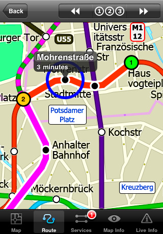
MINUTE MAP
Another great feature is the “Minute Map” option which allows you to see the travel times from a start point to all other locations on the map. This is a unique way to view the topology of a city and gauge traveling times.
ROUTING
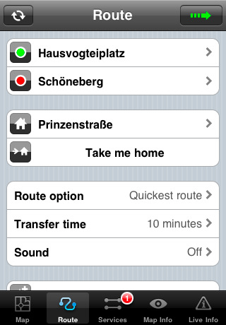
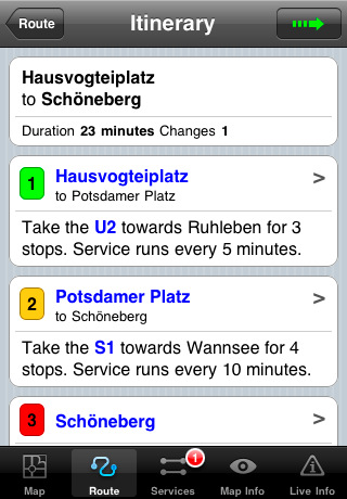
The application does not require an internet connection and will always be available to display a clear and detailed view of the city transport systems, plus list and animate the optimum route for your journey. This product provides the fastest route calculations of any mobile routing application (virtually instantaneous) using actual published journey times with the ability to select the quickest route or the route with the least changes.
· Full offline map and routing, no internet connection required.
· Colourful clear custom drawn geographically accurate mapping.
· Animates the route and allows tracking of the journey using GPS
· Instantly see the route of any transport service drawn on the map.
· Save and recall favourite and recent journeys.
· Take me home feature.
· Unique "Minute Map" feature allows quick view of all journey times from a start location.
· Services can be turned on or off, routing round problems.
· Works on iPhone or iPod and in landscape or portrait mode.
· GPS location and tracking.
· Streets, Places of interest etc built into the application.
What's New in This Release:
· Minor map update
Like it? Share with your friends!
If you got an error while installing Themes, Software or Games, please, read FAQ.
Supported operating systems:
Apple iOS 10.x (iPad), Apple iOS 10.x (iPhone), Apple iOS 11.x (iPad), Apple iOS 12.x (iPad), Apple iOS 12.x (iPhone), Apple iOS 4.0.x (iPhone), Apple iOS 4.0.x (iPod Touch), Apple iOS 4.2.x (iPad), Apple iOS 4.2.x (iPhone), Apple iOS 4.2.x (iPod Touch), Apple iOS 4.3.x (iPad), Apple iOS 4.3.x (iPhone), Apple iOS 4.3.x (iPod Touch), Apple iOS 5.0 (iPad), Apple iOS 5.0 (iPhone), Apple iOS 5.0 (iPod Touch), Apple iOS 6.0 (iPad), Apple iOS 6.0 (iPhone), Apple iOS 6.0 (iPod Touch), Apple iOS 7.0 (iPad), Apple iOS 7.0 (iPhone), Apple iOS 7.0 (iPod Touch), Apple iOS 8.x (iPad), Apple iOS 8.x (iPhone), Apple iOS 8.x (iPod Touch), Apple iOS 9.x (iPad), Apple iOS 9.x (iPhone), Apple iOS 9.x (iPod Touch), Apple iPhone OS 3.1.x, Apple iPhone OS 3.1.x (iPod Touch), Apple iPhone OS 3.2.x (iPad)
Similar Software:
Lancaster London (iPhone) Lancaster London (iPhone) - There's one thing that guests at Lancaster London always seem to agree on - the views are breathtaking. With Hyde Park, the largest of the Royal Parks, directly to the south, and vistas east to the City of London, we have arguably the best views in London
TripAdvisor for iPhone/iPad TripAdvisor for iPhone/iPad - TripAdvisor is your one stop for all your travel needs. It includes reviews and advice on hotels, restaurants, resorts, flights and more
Tucson & the Old Southwest Tucson & the Old Southwest - Indian lands, Spanish colony, Mexican outpost, wild western American territory and finally the State of Arizona - the history of the lands surrounding the 'Old Pueblo' makes for fascinating diversity and exciting exploration. Saguaro-studded desert to riverine canyons to pine-topped mountains - the geography is equally as diverse
TransitM&S Tucson TransitM&S Tucson - TransitM&S is an easy-to-use transit application that provides bus info for Sun Tran at the metro Tucson area.
The app is designed for offline use. It is ideal for iPod Touch users. Even for iPhone users, it is designed to save money because AT&T no longer offers the unlimited data plan
HipGeo HipGeo is the most convenient way to track where you go, take photos, record the world around you, and tell the story about where you've been or traveled. This is a great family communication and photo sharing tool
Pubs on 'n around royal mile Pubs on 'n around royal mile - GPSmyCity.com's directory guide is a powerful tool for planning your visit to a new city. Each directory guide comes with a well researched and detailed list of related attractions; such as museums, night clubs, restaurants, cafes, shops, etc. The powerful built-in navigation features provide travel directions to each venue
Airbnb for iPhone Airbnb for iPhone - The Airbnb app allows you to discover and book unique accommodations all over the world right from your iPhone.
Airbnb is a trusted community which connects you with people who have space for rent. It includes more than 200,000 listings in over 30,000 cities and 192 countries
London Tube by Zuti London Tube by Zuti - "London Tube 10" is a superb geographically based map and route planner for the London Underground, Overground, Docklands Light Railway (DLR), Croydon Tramlink and London Airport Express services. This is one in a worldwide series of Zuti maps from Visual IT who have been producing public transportation maps for mobile devices for many years
Booking.com for iPhone/iPad 6.0. Booking.com for iPhone/iPad 6.0. - Booking.com allows you to quickly find and book hotels right from your iPhone, iPad or iPod touch. The app includes a database of more than 250,000 places to stay from all over the world, along with over 17 million guest reviews and more than 2.6 million hotel photos.
With Booking
Viva Las Vegas, Baby! Viva Las Vegas, Baby! - Don't waste a single second of your next escape to Las Vegas. Get under the skin of the city right now, from the neon-lit Strip to downtown's Fremont Street and beyond
Other Software by developer «Visual IT»:
Rome Metro by Zuti Rome Metro by Zuti - The "Rome Metro" application is a superb geographically based map and route planner for the Rome Metro, Tram, Urban and Regional rail systems. This application is one in a worldwide series of Zuti maps from Visual IT who have been producing public transportation maps for mobile devices for many years
Tube 2 Budapest (UIQ3) Tube 2 Budapest (UIQ3) - This map package for Tube 2 consists of a fully scrollable detailed map of the Budapest metro system and HEV suburban railway.
Plan journeys on this system, list details of the quickest routes and see a superb animated display of your journey tracking around the system map
Tyne & Wear Metro by Zuti for iPad Tyne & Wear Metro by Zuti for iPad - The new Tyne & Wear Metro map makes it easy to travel in and around the city using the Nexus Metro system. Unlike old fashioned schematic style maps this product contains a geographically accurate central area showing major streets, parks and places of interest etc, allowing the user to easily get their bearings
Tube Hong Kong (Series 60) Tube Hong Kong (Series 60) - Our highly acclaimed Tube application that guides you around the subway system of Hong Kong is now available for your Series 60 Symbian powered phone. An essential addition to your phone for locals and tourists alike.
· A detailed clear colour map of the transport system fully scrollable.
· Quick find station utility
Tube 2 Boston (Palm OS) Tube 2 Boston (Palm OS) - This map package for Tube 2 consists of a fully scrollable detailed map of the Boston metro & commuter rail system.
Plan journeys on this system, list details of the quickest routes and see a superb animated display of your journey tracking around the system map
TUBE Engine UIQ3 Tube 2 Engine - Save hours by automatically having the quickest routes to hand, with all the details you need including line changes, platform directions and accurate journey times.
No more confusion on your trips, route details include, direction of travel, end of line, towards information, and number of stops in each segment
New York Subway by Zuti New York Subway by Zuti - The "New York Subway" application is a superb geographically based map and route planner for the New York public transport systems
Great Britain Rail for iPad by Zuti Great Britain Rail for iPad by Zuti - The new Great Britain Rail map makes it easy to travel in and around the country using the rail services. This application contains a geographically accurate map of the whole of Great Britain allowing you to easily view the route of any journey
Tube Sydney (Palm OS) Tube Sydney (Palm OS) - An award winning and highly acclaimed Palm OS application that guides you around the complex rail system of Sydney. An essential addition to your Palm device for locals and tourists alike.
Tube's features include:
A detailed clear colour (or grey scale) map of the transport system fully scrollable.
Quick find station utility
Tube 2 Berlin (UIQ) Tube 2 Berlin (UIQ) - This map package for Tube 2 consists of a fully scrollable detailed map of the Berlin Metro (U-Bahn/S-Bahn).
Plan journeys on this system, list details of the quickest routes and see a superb animated display of your journey tracking around the system map.
Berlin is the capital and largest city in Germany


")


")

")
")


")
")