Platforms: iPhone, iPad, iPod Touch, Apple iPhone OS
Categories: Travel & Navigation
Upload date: 29 Oct 11
Developer: Visual IT
License: Commercial
Price: 9.99 $
Downloads: 25
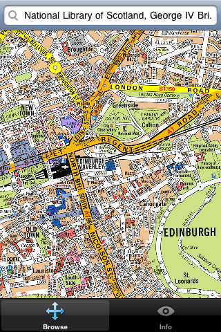
Edinburgh Mini A-Z - This street map of Edinburgh covers an area extending to Cramond, Granton, Leith, Portobello, Musselburgh, Whitecraig, Dalkeith, Bonnyrigg (part), Loanhead, Fairmilehead, Juniper Green, Currie, Balerno, and Edinburgh Airport.
Major buildings are colour-coded to indicate places of interest and other buildings that are open to the public.
Also included is a listing of hospitals, hospices, and NHS Walk-in Centres that are within this area.
The index section of the atlas lists: streets, walkways, places of interest, selected flats, place and area names plus National Rail and Metrolink stations.
This map is drawn by real cartographers with the detailed care and human touch of emphasis and colour that A-Z are famous for. Internet maps are OK but you really can’t beat the genuine article.
With this map installed on your device there is never any need for an internet connection enabling you to access the map anywhere and at anytime. This application starts up in under 5 seconds and can find any location on the map in under 2 seconds. You can also use your inbuilt location services (GPS, Wifi, etc) to locate your position on the map.
Visual IT have partnered with the “Geographers A-Z Map Company” and negotiated a license to produce this map for iPhone or iPod Touch users at this very competitive price.
What's New in This Release:
· Support for retina display
· New "Measure Tool"
· Bug fix for the next iOS release
Like it? Share with your friends!
If you got an error while installing Themes, Software or Games, please, read FAQ.
Supported operating systems:
Apple iOS 10.x (iPad), Apple iOS 10.x (iPhone), Apple iOS 11.x (iPad), Apple iOS 12.x (iPad), Apple iOS 12.x (iPhone), Apple iOS 4.0.x (iPhone), Apple iOS 4.0.x (iPod Touch), Apple iOS 4.2.x (iPad), Apple iOS 4.2.x (iPhone), Apple iOS 4.2.x (iPod Touch), Apple iOS 4.3.x (iPad), Apple iOS 4.3.x (iPhone), Apple iOS 4.3.x (iPod Touch), Apple iOS 5.0 (iPad), Apple iOS 5.0 (iPhone), Apple iOS 5.0 (iPod Touch), Apple iOS 6.0 (iPad), Apple iOS 6.0 (iPhone), Apple iOS 6.0 (iPod Touch), Apple iOS 7.0 (iPad), Apple iOS 7.0 (iPhone), Apple iOS 7.0 (iPod Touch), Apple iOS 8.x (iPad), Apple iOS 8.x (iPhone), Apple iOS 8.x (iPod Touch), Apple iOS 9.x (iPad), Apple iOS 9.x (iPhone), Apple iOS 9.x (iPod Touch), Apple iPhone OS 3.1.x, Apple iPhone OS 3.1.x (iPod Touch), Apple iPhone OS 3.2.x (iPad)
Similar Software:
Toledo (OH, USA) Map Offline Toledo (OH, USA) Map Offline - This will be perfect when you are traveling and you don't have internet connection. This Offline Maps is not a replacement of Google Maps. It is used when you don't have internet connection and want to use maps
Anchorage (Alaska) Map Offline Anchorage (Alaska) Map Offline - This will be perfect when you are traveling and you don't have internet connection. This Offline Maps is not a replacement of Google Maps. It is used when you don't have internet connection and want to use maps
Denver Maps Offline Denver Maps Offline - This will be perfect when you are traveling and you don't have internet connection. This Offline Maps is not a replacement of Google Maps. It is used when you don't have internet connection and want to use maps
Saint Louis Walking Tours and Map Saint Louis Walking Tours and Map - No need to hop on a tour bus or join a group; now you can explore all the best attractions on your own, at your own pace, and at a cost that is only a fraction of what you would normally pay for a guided tour
Krakow Map and Walking Tours Krakow Map and Walking Tours - No need to hop on a tour bus or join a group; now you can explore all the best attractions on your own, at your own pace, and at a cost that is only a fraction of what you would normally pay for a guided tour
Channel Islands National Park - Standard Channel Islands National Park - Standard - Continues in the tradition of offering depth of information and functionality across expected places all over the world, exploring the map you get maximum details obtaining detailed information of each object on the map
Fort Worth Map Offline Fort Worth Map Offline - This will be perfect when you are traveling and you don't have internet connection. This Offline Maps is not a replacement of Google Maps. It is used when you don't have internet connection and want to use maps
The Dealmap The Dealmap app is the most comprehensive source for people to find and share the hottest local deals, coupons and discounts, and the only app that aggregates local daily deals in one place. Available throughout the U.S. and U.K., The Dealmap aggregates more than 350,000 local deals, including special offers from nearly 100 popular local daily deal sources
Wellington Walking Tours and Map This application presents you several self-guided walking tours to see the best of the city, and it comes with detailed tour route maps and powerful navigation features to guide you from one sight to the next
America Maps - Touch States America Maps - Touch States - Get a convenient and comprehensive collection of 50 USA state maps in your pocket today!
Now with maps of:
- North America
- Central America
- South America
View the 50 State maps easily by scrolling and zooming.
Take screen shots of any map for your personal use.
Touch States is great for school, work, leisure or anything else
Other Software by developer «Visual IT»:
Tube Vienna (UIQ) Tube Vienna (UIQ) - Our award winning and highly acclaimed application that guides you around the metro system of Vienna is now available for your Symbian UIQ phone.
An essential addition to your P800 / P900 / P910 if you travel in or around this city.
· A detailed clear colour map of the Vienna metro system fully scrollable.
· Quick find station utility
New York Subway by Zuti New York Subway by Zuti - The "New York Subway" application is a superb geographically based map and route planner for the New York public transport systems
Tube Montreal (UIQ) Tube Montreal (UIQ) - Our award winning and highly acclaimed application that guides you around the metro system of Montreal is now available for your Symbian UIQ phone.
An essential addition to your P800 / P900 / P910 if you travel in or around this city.
· A detailed clear colour map of the Montreal metro system fully scrollable
Tube 2 Paris (UIQ3) Tube 2 Paris (UIQ3) - This map package for Tube 2 consists of a fully scrollable detailed map of the Paris metro and RER system.
Plan journeys on this system, list details of the quickest routes and see a superb animated display of your journey tracking around the system map
Tube Rome (Series 60) Tube Rome (Series 60) - Our highly acclaimed Tube application that guides you around the metro & rail system of Rome is now available for your Series 60 Symbian powered phone. An essential addition to your phone for locals and tourists alike.
· A detailed clear colour map of the Rome metro & rail system fully scrollable.
· Quick find station utility
Tube 2 Melbourne (Palm OS) Tube 2 Melbourne (Palm OS) - This map package for Tube 2 consists of a fully scrollable detailed map of the Melbourne metro & rail system.
Plan journeys on this system, list details of the quickest routes and see a superb animated display of your journey tracking around the system map
London Bus for iPad by Zuti London Bus for iPad by Zuti - The new Zuti London Bus map has finally arrived, making it easy to travel by bus anywhere in central London. This clear and colourful map covers a detailed street level area of 6 miles by 4 miles and includes over 1300 bus stops and 189 bus routes
London Visitors A-Z London Visitors A-Z - The London Visitors Map of central London is designed especially for the tourist. The principal feature of the mapping is the highlighting of places of interest, buildings open to the public, theatres, cinemas, selected shops and stores, main shopping streets, main line and underground railway stations and other locations of interest to the visitor
London Central Bus 10 London Central Bus 10 - The new Zuti London Bus map has finally arrived, making it easy to travel by bus anywhere in central London. This clear and colourful map covers a detailed street level area of 6 miles by 4 miles and includes over 1300 bus stops and 189 bus routes
Rough Guides Map Paris Rough Guides Map Paris... These guides are a series of fantastic interactive maps.
Produced in conjunction with the premier travel publisher Rough Guides.
Discover and explore Paris using full colour interactive linked maps, in this simple to use PDA version of The Rough Guides Paris

")


 Map Offline")
 Map Offline")


")

")
")
")
")


