Platforms: iPhone, iPad, iPod Touch, Apple iPhone OS
Categories: Travel & Navigation
Upload date: 11 May 13
Developer: Visual IT
License: Commercial
Price: 1.99 $
Downloads: 15
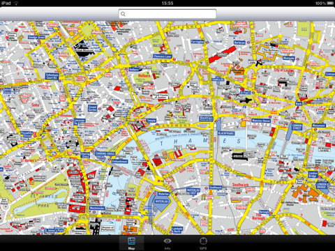
London Visitors A-Z for iPad - The London Visitors A-Z map of central London is designed especially for the tourist. The principal feature of the mapping is the highlighting of places of interest, buildings open to the public, theatres, cinemas, selected shops and stores, main shopping streets, main line and underground railway stations and other locations of interest to the visitor. Road information shown includes A and B roads, bus routes and a selection of principal minor roads.
This map is drawn by real cartographers with the detailed care and human touch of emphasis and colour that A-Z are famous for.
With the maps installed on your device there is never any need for an internet connection enabling you to access the map anywhere and at anytime. This application starts up instantly and can find any location on the map immediately. You can also use your inbuilt location services (GPS, Wifi, etc) to locate your position on the map.
Visual IT has partnered with the “Geographers A-Z Map Company” and negotiated a license to produce this map for iPad users at this very competitive price.
Add this map to one of our “Zuti” route planner maps (the classic “Zuti - London Underground” or the geographically based version “Zuti – London Tube” or if travelling by bus the “Zuti – London Bus”) and you are well equipped to travel anywhere in the central London area.
COVERAGE
The map covers an area extending from Charing Cross to:- St. John's Wood, Regent's Park, St. Pancras International Station, Shoreditch, Tower Bridge, Bermondsey, Newington, Westminster, Sloane Square, South Kensington, Earl's Court, Kensington High Street, Bayswater and Maida Vale.
· Full offline map with inbuilt search facility.
· Colourful clear custom drawn geographically accurate mapping.
· No internet connection required, no data roaming charges, works on all devices.
· GPS location and tracking.
· Streets, Places of interest, Museums and Galleries etc built into the application.
What's New in This Release:
· Updated for iPhone 5 display
· Now a universal app that runs on iPhone and iPad
Like it? Share with your friends!
If you got an error while installing Themes, Software or Games, please, read FAQ.
Supported operating systems:
Apple iOS 10.x (iPad), Apple iOS 10.x (iPhone), Apple iOS 11.x (iPad), Apple iOS 12.x (iPad), Apple iOS 12.x (iPhone), Apple iOS 4.3.x (iPad), Apple iOS 4.3.x (iPhone), Apple iOS 4.3.x (iPod Touch), Apple iOS 5.0 (iPad), Apple iOS 5.0 (iPhone), Apple iOS 5.0 (iPod Touch), Apple iOS 6.0 (iPad), Apple iOS 6.0 (iPhone), Apple iOS 6.0 (iPod Touch), Apple iOS 7.0 (iPad), Apple iOS 7.0 (iPhone), Apple iOS 7.0 (iPod Touch), Apple iOS 8.x (iPad), Apple iOS 8.x (iPhone), Apple iOS 8.x (iPod Touch), Apple iOS 9.x (iPad), Apple iOS 9.x (iPhone), Apple iOS 9.x (iPod Touch)
Similar Software:
Austin Map and Walking Tours Austin Map and Walking Tours - This Lite version of the walking tours application comes with a detailed and fully functional city map to assist you explore the city and locate sights. City map functions in this app include: street name and business (restaurants, cafes, etc
Kitchener Maps Offline Kitchener Maps Offline - This will be perfect when you are traveling and you don't have internet connection. This Offline Maps is not a replacement of Google Maps. It is used when you don't have internet connection and want to use maps
Manchester Mini A-Z Manchester Mini A-Z - "Manchester Mini A-Z" is a digital rendition of the famous Geographers Company Mini A-Z Atlas for Manchester
Nashville Map Offline Nashville Map Offline - This will be perfect when you are traveling and you don't have internet connection. This Offline Maps is not a replacement of Google Maps. It is used when you don't have internet connection and want to use maps
Smart Maps - Houston Smart Maps - Houston - Smart Maps offers you an offline street level map, allowing you to search or navigate without an internet connection. Smart Maps will save you the money you pay for expensive data roaming charges or additional costs for local internet traffic.
· No internet connection required
Innsbruck Maps Offline Innsbruck Maps Offline - This will be perfect when you are traveling and you don't have internet connection. This Offline Maps is not a replacement of Google Maps. It is used when you don't have internet connection and want to use maps
Angers Street Map Angers Street Map - Lets you find all streets, and many useful locations such as ATM's, parkings, museums, and many others. Remembers where you've been so you can find that parking spot where you left your rental car
Vilnius Travel Guide Vilnius Travel Guide - Stop carrying heavy city tours guide in your pocket. TRAVEL LIGHT!!!
With Etips City Travel Guides you have a full city guide in your iPhone or iPod touch.
This tourist guide is built to be used offline
Caen (FR) Street Map Caen (FR) Street Map - Lets you find all streets, and many useful locations such as ATM's, parkings, museums, and many others. Remembers where you've been so you can find that parking spot where you left your rental car
Other Software by developer «Visual IT»:
Tube 2 Portland (UIQ) Tube 2 Portland (UIQ) - This map package for Tube 2 consists of a fully scrollable detailed map of the Portland rail system.
Plan journeys on this system, list details of the quickest routes and see a superb animated display of your journey tracking around the system map
Tube 2 London Streets (Palm OS) Tube 2 London Streets (Palm OS) - This map package for Tube 2 consists of a fully scrollable detailed map of the London Underground system and 9 linked A-Z street maps.
Plan journeys on the London Underground system, list details of the quickest routes and see a superb animated display of your journey tracking around the system map
Tube 2 Atlanta (Palm OS) Tube 2 Atlanta (Palm OS) - This map package for Tube 2 consists of a fully scrollable detailed map of the Atlanta rail system.
Plan journeys on this system, list details of the quickest routes and see a superb animated display of your journey tracking around the system map
Tube 2 Boston (UIQ) Tube 2 Boston (UIQ) - This map package for Tube 2 consists of a fully scrollable detailed map of the Boston metro & commuter rail system.
It includes all city metro lines along with the MBTA commuter rail system and also includes the five commuter boat routes which cross the bay
Tube 2 Barcelona (Palm OS) Tube 2 Barcelona (Palm OS) - This map package for Tube 2 consists of a fully scrollable detailed map of the Barcelona metro & rail system.
Plan journeys on the metro system, list details of the quickest routes and see a superb animated display of your journey tracking around the system map
Tube 2 Melbourne (UIQ) Tube 2 Melbourne (UIQ) - This map package for Tube 2 consists of a fully scrollable detailed map of the Melbourne metro & rail system.
Plan journeys on this system, list details of the quickest routes and see a superb animated display of your journey tracking around the system map
London Mini A-Z London Mini A-Z - This map is a digital rendition of the famous "London A-Z Mini Atlas" and covers an area from West Hendon in the North West to Grove Park in the South East. Add this application to your iPhone or iPod Touch and you will have instant access to all 352 pages of the London Mini A-Z printed map
Tube 2 Tokyo (UIQ) Tube 2 Tokyo (UIQ) - This map package for Tube 2 consists of a fully scrollable detailed map of the Tokyo city subway & JR rail system
Tube 2 Paris Touristic (UIQ3) Tube 2 Paris Touristic (UIQ3) - This map package for Tube 2 is the ideal map for the tourist or business traveller who needs to get around Paris using the metro system and would like to know just exactly where they are. The map geographically locates all the central stations, making it much more informative than the official topological map
Tube 2 Baltimore (UIQ3) Tube 2 Baltimore (UIQ3) - This map package for Tube 2 consists of a fully scrollable detailed map of the Baltimore metro & rail system.
Plan journeys on this system, list details of the quickest routes and see a superb animated display of your journey tracking around the system map

")


 Street Map")
")
")
")
")
")
")

")
")
")