Platforms: iPhone, iPad, iPod Touch, Apple iPhone OS
Categories: Travel & Navigation
Upload date: 16 May 11
Developer: Visual IT
License: Commercial
Price: 2.99 $
Downloads: 32
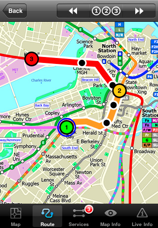
Boston Subway by Zuti - The new Boston Subway map makes it easy to travel in and around the city using the MBTA Subway, MBTA Commuter Rail, MBTA Boats, and Massport shuttle buses. Unlike old fashioned schematic style maps this product contains a geographically accurate central area showing major streets, parks and places of interest etc, allowing the user to easily get their bearings.
MAP
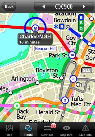
The map is hand drawn by Visual IT and provides a unique geographically based view of Boston with many places of interest drawn directly on the background so you can easily get your bearings when traveling around the city. You can also use your inbuilt GPS to accurately locate and track yourself within the city centre and see the nearest transportation stop and distance to it. This is the only public transportation route planner with this ability.
Tap on the map for location information, use the inbuilt search feature or choose from a list of locations. Places of interest, museums, hotels, parks, restaurant, shops, hospitals, streets, etc, are also included. The route planner will automatically suggest the nearest station to any place of interest you select.
MINUTE MAP
Another great feature is the “Minute Map” option which allows you to see the travel times from a start point to all other locations on the map. This is a unique way to view the topology of a city and gauge traveling times.
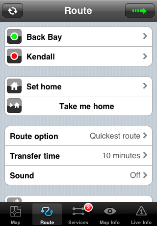
ROUTING
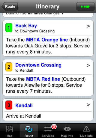
The application does not require an internet connection and will always be available to display a clear and detailed view of the city transport systems, plus list and animate the optimum route for your journey. This product provides the fastest route calculations of any mobile routing application (virtually instantaneous) using actual published journey times with the ability to select the quickest route or the route with the least changes.
LIVE INFO
When an internet connection is available, optional "Live Information" on the current state of the transport services can be viewed, allowing you to plan your journeys in advance and avoid any potential delays. Unique to this application is the ability to turn off services that are out of action and automatically calculate an alternative route.
· Full offline map and routing, no internet connection required.
· Colourful clear custom drawn geographically accurate mapping.
· Animates the route and allows tracking of the journey using GPS
· Instantly see the route of any transport service drawn on the map.
· Save and recall favorite and recent journeys.
· Take me home feature.
· Unique "Minute Map" feature allows quick view of all journey times from a start location.
· Services can be turned on or off, routing round problems.
· Works on iPhone or iPod and in landscape or portrait mode.
· GPS location and tracking.
· Streets, Places of interest etc built into the application.
· Access to live service information.
Like it? Share with your friends!
If you got an error while installing Themes, Software or Games, please, read FAQ.
Supported operating systems:
Apple iOS 10.x (iPad), Apple iOS 10.x (iPhone), Apple iOS 11.x (iPad), Apple iOS 12.x (iPad), Apple iOS 12.x (iPhone), Apple iOS 4.0.x (iPhone), Apple iOS 4.0.x (iPod Touch), Apple iOS 4.2.x (iPad), Apple iOS 4.2.x (iPhone), Apple iOS 4.2.x (iPod Touch), Apple iOS 4.3.x (iPad), Apple iOS 4.3.x (iPhone), Apple iOS 4.3.x (iPod Touch), Apple iOS 5.0 (iPad), Apple iOS 5.0 (iPhone), Apple iOS 5.0 (iPod Touch), Apple iOS 6.0 (iPad), Apple iOS 6.0 (iPhone), Apple iOS 6.0 (iPod Touch), Apple iOS 7.0 (iPad), Apple iOS 7.0 (iPhone), Apple iOS 7.0 (iPod Touch), Apple iOS 8.x (iPad), Apple iOS 8.x (iPhone), Apple iOS 8.x (iPod Touch), Apple iOS 9.x (iPad), Apple iOS 9.x (iPhone), Apple iOS 9.x (iPod Touch), Apple iPhone OS 3.1.x, Apple iPhone OS 3.1.x (iPod Touch), Apple iPhone OS 3.2.x (iPad)
Similar Software:
Miami Maps Miami Maps - software that helps you download and store the travel maps and plans you need. This super-handy app lets you download publicly available maps and store them on your iPhone or iPod Touch. You can download the maps when you have fast wifi connection - and then use any time in the future without delay
San Antonio Driving Tours This revolutionary application presents you several driving tours designed to show you the best of the city, as it comes with detailed tour route maps and powerful navigation features to guide you from one sight to the next
HomeAway HomeAway - Download the FREE HomeAway app to browse nearly 230,000 worldwide vacation rental property listings! The map and sorting tools make it easy to search for a vacation rental. Each listing features vibrant, full-screen property photos and the ability to inquire directly from your mobile phone. Once you've found one you like, you can share it with your social networks
TripDeck TripDeck - The best itinerary organizer out there – and it’s FREE. Manage your hotel reservations, car rentals, flights, cruises, restaurants, meetings and more with easy-to-read Trip Decks for each itinerary. You can also view your entire itinerary on a gorgeous map
Los Angeles Maps Los Angeles Maps - software that helps you download and store the travel maps and plans you need. This super-handy app lets you download publicly available maps and store them on your iPhone or iPod Touch. You can download the maps when you have fast wifi connection - and then use any time in the future without delay
Tuscany for Foodies Tuscany for Foodies - Tuscany for Foodies introduces you to the best of foodie Tuscany, from the butchers, bakers, and cheese makers who adhere to ancient traditions and proudly sell their goods in small shops, to restaurants large and small that process local ingredients into good-to-eat meals
Tube Vienna (iPhone) Tube Vienna (iPhone) is a superb interactive guide to the Vienna Metro (U-Bahn) and Vienna Tram (StrassenBahn) systems.
With no need for an internet connection Tube Vienna will always be available to display a clear and detailed view of the city transport systems, plus list and animate the optimum route for all your journeys
ATHENS, GREECE CITY ATLAS & TRAVEL SEARCH ENGINE ATHENS, GREECE CITY ATLAS & TRAVEL SEARCH ENGINE - ATLAS & TRAVEL SEARCH ENGINE
· Trip planning tool.
· GPS Companion.
· ZOOM TOUCH capability with 2-fingers.
· RE-CENTER TOUCH capability with 1-finger.
· Portrait or landscape views.
· Take a picture of your screen.
· Then print or e-mail regularly as desired
Denver Maps Denver Maps - Software that helps you download and store the travel maps and plans you need. This super-handy app lets you download publicly available maps and store them on your iPhone or iPod Touch. You can download the maps when you have fast wifi connection - and then use any time in the future without delay
Palm Springs Driving Tours This application presents you several driving tours designed to show you the best of the city, as it comes with detailed tour route maps and powerful navigation features to guide you from one sight to the next
Other Software by developer «Visual IT»:
London Visitors A-Z London Visitors A-Z - The London Visitors Map of central London is designed especially for the tourist. The principal feature of the mapping is the highlighting of places of interest, buildings open to the public, theatres, cinemas, selected shops and stores, main shopping streets, main line and underground railway stations and other locations of interest to the visitor
Tube 2 Paris Touristic (UIQ) Tube 2 Paris Touristic (UIQ) - This map package for Tube 2 is the ideal map for the tourist or business traveller who needs to get around Paris using the metro system and would like to know just exactly where they are. The map geographically locates all the central stations, making it much more informative than the official topological map
Madrid Metro by Zuti Madrid Metro by Zuti - The new Madrid Metro 10 map makes it easy to travel in and around the city using the the Metro, Renfe Rail and Metro Ligero Rail services. Unlike old fashioned schematic style maps this product contains a geographically accurate central area showing major streets, parks and places of interest etc, allowing the user to easily get their bearings
New York Subway 10 for iPad New York Subway 10 - The “New York Subway” application is a superb geographically based map and route planner for the New York public transport systems
San Francisco Metro for iPad by Zuti San Francisco Metro for iPad by Zuti - The new San Francisco Metro 10 application makes it easy to travel in and around the city using the Metro (BART), Streetcar, Light Rail(MUNI), Ferry and Presidio shuttle bus services
Rough Guides Map Dublin Rough Guides Map Dublin... These guides are a series of fantastic interactive maps.
Produced in conjunction with the premier travel publisher Rough Guides.
Discover and explore Dublin using full colour interactive linked maps, in this simple to use PDA version of The Rough Guides Dublin
Tube 2 Amsterdam Pro (UIQ) Tube 2 Amsterdam Pro (UIQ) - This map package for Tube 2 consists of a fully scrollable detailed map of the Amsterdam tram & metro system and linked street maps of central Amsterdam.
Plan journeys on the tram & metro system, list details of the quickest routes and see a superb animated display of your journey tracking around the system map
Tube 2 Los Angeles (UIQ3) Tube 2 Los Angeles (UIQ3) - This map package for Tube 2 consists of a fully scrollable detailed map of the Los Angeles rail system.
Plan journeys on this system, list details of the quickest routes and see a superb animated display of your journey tracking around the system map
London Congestion Charge Map (UIQ) London Congestion Charge Map (UIQ) - This map package is an essential addition to your Tube 2 maps if you drive in or around central London.
This reference map gives you a clear view of the area now covered by the congestion charge system, complete with a quick find utility to help you find any major road or street in and around the area
Tube 2 Munich (Palm OS) Tube 2 Munich (Palm OS) - This map package for Tube 2 consists of a fully scrollable detailed map of the Munich metro, rail & tram system.
Plan journeys on this system, list details of the quickest routes and see a superb animated display of your journey tracking around the system map.
Munich is the capital city of Bavaria, the southern most German federal state

")


")


")


")
")
")
")