Platforms: iPhone, iPad, iPod Touch, Apple iPhone OS
Categories: Travel & Navigation
Upload date: 29 Sep 11
Developer: National Geographic Society
License: Commercial
Price: 4.99 $
Downloads: 26
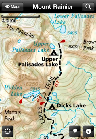
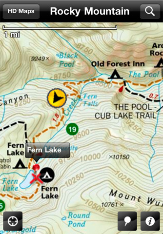
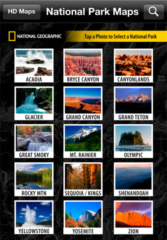
National Park Maps HD - Explore 15 of the top US National Parks with the best collection of trail maps available. National Geographic - THE place for maps - has opened up their best-selling, detailed Trails Illustrated National Parks Maps for download to your favorite Apple device. Plan your trip by browsing the maps and marking places you'd like to see. When visiting, use your iPhone or iPad to help you find your way around the park. A great gift application for your favorite outdoor adventurer, family trip planner or armchair explorer! MAPS FOR 15 GREAT NATIONAL PARKS:
· Acadia - Bryce Canyon - Canyonlands - Glacier/Waterton - Grand Canyon - Grand Teton - Great Smoky Mountains - Mount Rainier - Olympic - Rocky Mountain - Sequoia/Kings Canyon - Shenandoah - Yellowstone - Yosemite - Zion
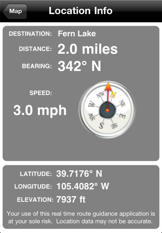
MAPS THAT KNOW WHERE YOU ARE:
· See your current position on the map
· Know how far it is to your destination
· Mark your campsite or car for an easy return
MAPS THAT KNOW WHAT'S AROUND YOU:
· Search for places by name or browse by category to see what's nearby
· Find campgrounds, picnic areas, visitor centers and other facilities
· Find trails, waterfalls, lakes, summits and other points of interest
MAPS THAT GET YOU WHERE YOU WANT TO GO:
· Includes National Park Service maps to get you around the park
· Plus more detailed Trails Illustrated maps to get you off the beaten path
· Download HD maps for even more zoom levels at no additional charge
· Bonus trip planning info - park phone numbers, campground lists, and more
· Offline access - maps work without any cell or WiFi connection
A GREAT VALUE:
· Contains a retail equivalent of over $300.00 of detailed Trails Illustrated Maps
What's New in This Release:
· Enhanced zoom functionality
Like it? Share with your friends!
If you got an error while installing Themes, Software or Games, please, read FAQ.
Supported operating systems:
Apple iOS 10.x (iPad), Apple iOS 10.x (iPhone), Apple iOS 11.x (iPad), Apple iOS 12.x (iPad), Apple iOS 12.x (iPhone), Apple iOS 4.0.x (iPhone), Apple iOS 4.0.x (iPod Touch), Apple iOS 4.2.x (iPad), Apple iOS 4.2.x (iPhone), Apple iOS 4.2.x (iPod Touch), Apple iOS 4.3.x (iPad), Apple iOS 4.3.x (iPhone), Apple iOS 4.3.x (iPod Touch), Apple iOS 5.0 (iPad), Apple iOS 5.0 (iPhone), Apple iOS 5.0 (iPod Touch), Apple iOS 6.0 (iPad), Apple iOS 6.0 (iPhone), Apple iOS 6.0 (iPod Touch), Apple iOS 7.0 (iPad), Apple iOS 7.0 (iPhone), Apple iOS 7.0 (iPod Touch), Apple iOS 8.x (iPad), Apple iOS 8.x (iPhone), Apple iOS 8.x (iPod Touch), Apple iOS 9.x (iPad), Apple iOS 9.x (iPhone), Apple iOS 9.x (iPod Touch), Apple iPhone OS 3.1.x, Apple iPhone OS 3.1.x (iPod Touch), Apple iPhone OS 3.2.x (iPad)
Similar Software:
Nassau Walking Tours and Map This application presents you several self-guided walking tours to see the best of the city, and it comes with detailed tour route maps and powerful navigation features to guide you from one sight to the next
High Definition Switzerland Atlas (New Zoom) - HD Deluxe High Definition Switzerland Atlas (New Zoom) - HD Deluxe - Each map can be amplified several times.
The special customized Atlas Guide can get information such as:
flags
maps
travel information
touristic top locations
history
currencies
trivia
humor
pictures
videos
museums information
restaurant information
accommodations / hotel
Genova Street Map Genova Street Map - Lets you find all streets, and many useful locations such as ATM's, parkings, museums, and many others. Remembers where you've been so you can find that parking spot where you left your rental car
Smart Maps - Budapest Smart Maps - Budapest - offers you an offline street level map, allowing you to search or navigate without an internet connection. Smart Maps will save you the money you pay for expensive data roaming charges or additional costs for local internet traffic.
· No internet connection required
Basel Street Map Basel Street Map - Lets you find all streets, and many useful locations such as ATM's, parkings, museums, and many others. Remembers where you've been so you can find that parking spot where you left your rental car. To make sure your phone doesn't use any expensive data on your trip, go to Settings, then General, tap on Network, and slide the Data Roaming to "off"
Heidelberg Offline Street Map Heidelberg Offline Street Map - You don't need to have internet connection for this to work as the map is stored on your iPhone or iPod Touch. Ideal for saving roaming charges or having to find the local wifi to access the built-in map application.
What's New in This Release:
· iOS 5 compatibility changes.
· Further bug fixes and improvements
Smart Maps - Rio de Janeiro Smart Maps - Rio de Janeiro - Smart Maps offers you an offline street level map, allowing you to search or navigate without an internet connection. Smart Maps will save you the money you pay for expensive data roaming charges or additional costs for local internet traffic.
· No internet connection required
London Mini A-Z London Mini A-Z - This map is a digital rendition of the famous "London A-Z Mini Atlas" and covers an area from West Hendon in the North West to Grove Park in the South East. Add this application to your iPhone or iPod Touch and you will have instant access to all 352 pages of the London Mini A-Z printed map
Blackpool Street Map Lite Blackpool Street Map Lite - Lets you find all streets, and many useful locations such as ATM's, parkings, museums, and many others. Remembers where you've been so you can find that parking spot where you left your rental car
Cuba - GPS Map Navigator Cuba - GPS Map Navigator - FlytoMap provides complete, quick and easy to use map applications for navigation for iPhone. Continues in the tradition of offering depth of information and functionality across expected places all over the world, exploring the map you get maximum details obtaining detailed information of every object on the map
Other Software by developer «National Geographic Society»:
GeoBee Challenge by National Geographic GeoBee Challenge by National Geographic - Now with beautiful maps from National Geographic, explore the world while testing your smarts.
This is a challenging game, so it's not for beginners...but do keep in mind that the National Geographic Bee is meant for kids in grades 4-8.
Three types of game play make sure you really know your stuff and never get bored
National Geographic Kids National Geographic Kids - Subscriptions to National Geographic Kids magazine are now available! Download the application and you'll receive a free sample.
National Geographic Kids on iPad showcases each issue with engaging interactive content and dynamic functionality. You’ll get amazing facts, photos, and fun
Ultimate Dinopedia: The Most Complete Dinosaur Reference Ever Ultimate Dinopedia: The Most Complete Dinosaur Reference Ever - Based on the award-winning NATIONAL GEOGRAPHIC KIDS ULTIMATE DINOPEDIA: The Most Complete Dinosaur Reference Ever, this app goes beyond any dinosaur encyclopedia you have ever seen
Great Migrations HD Use your wits and skill to keep your animals from being attacked by hungry predators and on the path toward safety!
National Geographic World Atlas National Geographic World Atlas - Designed specifically for the iPad, National Geographic's new and improved World Atlas HD puts our best maps in the palm of your hand
The World by National Geographic The World by National Geographic - Exclusively designed to leverage features and functionality for the iPad, The World by National Geographic provides one-touch access to locations worldwide
National Geographic's Handheld Birds National Geographic's Handheld Birds - Based on the best-selling book, National Geographic Field Guide to the Birds of North America, National Geographic Handheld Birds is a breakthrough in birding. It was the first North American multimedia software program to empower birders of all levels with easy-to-use interactive referencing capabilities
World Atlas by National Geographic World Atlas by National Geographic - Designed specifically for the iPhone and iPod touch, National Geographic's new and improved World Atlas puts our best maps in the palm of your hand
Building Titanic Building Titanic - In 1912, she was the largest, most complex moving object on the planet and it took a workforce of thousands more than two years to bring her to life.
Now, with the free Building Titanic application, travel back in time and witness Titanic's construction
National Geographic Magazine National Geographic Magazine - Subscriptions to National Geographic magazine are now available! Download National Geographic magazine on iPad and you can get a sample issue for free!
National Geographic magazine on iPad showcases each month’s issue with exclusive content and enhanced functionality

")


 - HD Deluxe")


