Platforms: iPhone, iPad, iPod Touch, Apple iPhone OS
Categories: Travel & Navigation
Upload date: 6 Aug 13
Developer: National Geographic Society
License: Commercial
Price: 1.99 $
Downloads: 28
National Geographic World Atlas - Designed specifically for the iPad, National Geographic's new and improved World Atlas HD puts our best maps in the palm of your hand.
The Best Maps
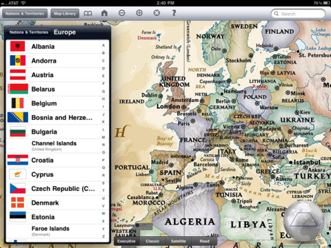
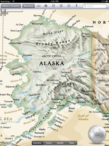
Unlike other map applications, the National Geographic World Atlas HD utilizes our highest resolution, press-ready images, providing you the same rich detail, accuracy, and artistic beauty found in our award-winning wall maps and bound atlases. The app is preloaded with 3 different styles of world maps, down to country-level detail. With an internet connection, you can continue zooming through continent-level maps into detailed Microsoft Bing maps - close enough to see your home!
Browse the world as you once did in your classroom with the new interactive 3D globe. Spin, pan, rotate and switch between three different map styles including our classic (blue-ocean), executive (antique-inspired) and satellite image.
World Flags and Facts
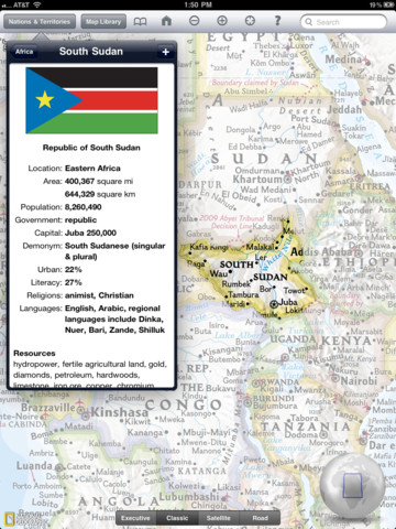
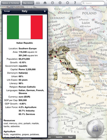
Learn more about the world around you using the up-to-date, expertly researched Flags and Facts database which contains concise geographic and socio-economic data plus recent updates to places like Southern Sudan.
The new touch-and-hold feature makes learning about the World's nations and territories easier. Simply touch-and-hold a place on the 3D globe or any map to pop-up the location's flag-and-fact page.
Search and Bookmark
Bookmark your favorite places with push pins and notes. Center the map to your current position. Find places by name using the built-in index of major world cities or the full online search of nearly 7 million places.
What's New in This Release:
· This update addresses a small bug that occurred when tapping the following territories and islands: Kerguelen Islands (France), Ole Amsterdam (France), Crozet Islands (France), South Georgia and South Sandwich Islands (United Kingdom)
What's New in 3.0:
· Completely redesigned!
· Updated country information!
· Brand new, seamless, high-resolution world map layers!
· Store pins in the cloud and share them across devices
· Add and customize collections of map pins
· Get up-to-the-minute weather for countries and capital cities
· Currency Calculator lets you check the latest currency conversion rates
· Latitude and Longitude indication included throughout
Like it? Share with your friends!
If you got an error while installing Themes, Software or Games, please, read FAQ.
Supported operating systems:
Apple iOS 10.x (iPad), Apple iOS 10.x (iPhone), Apple iOS 11.x (iPad), Apple iOS 12.x (iPad), Apple iOS 12.x (iPhone), Apple iOS 5.0 (iPad), Apple iOS 5.0 (iPhone), Apple iOS 5.0 (iPod Touch), Apple iOS 6.0 (iPad), Apple iOS 6.0 (iPhone), Apple iOS 6.0 (iPod Touch), Apple iOS 7.0 (iPad), Apple iOS 7.0 (iPhone), Apple iOS 7.0 (iPod Touch), Apple iOS 8.x (iPad), Apple iOS 8.x (iPhone), Apple iOS 8.x (iPod Touch), Apple iOS 9.x (iPad), Apple iOS 9.x (iPhone), Apple iOS 9.x (iPod Touch)
Similar Software:
Spain Map Spain Map - This application enables you to use maps offline without internet connection. This includes maps street names detail. This will give peace of mind when traveling aboard knowing you will not be charged with roaming fee. So if you live or travel in that city, it will help you much in your life
San Francisco City Atlas (High Definition Zoom) * GPS Travel Companion USA San Francisco City Atlas (High Definition Zoom) * GPS Travel Companion USA - Each map can be amplified several times.
The special customized Atlas Guide can get information such as:
flags
maps
travel information
touristic top locations
history
currencies
trivia
humor
pictures
videos
museums information
restaurant information
accommodations / hotel
Google Maps (iPhone) Google Maps (iPhone) - Google Maps is a comprehensive map solution for iOS devices. It offers accurate maps, voice guided turn-by-turn driving directions, live traffic information, public transit directions, Street View, and more.
With Google Maps, you can easily find points of interest around you, such as restaurants, pubs, shops, hotels, and more
London Walking Tours and Map London Walking Tours and Map - No need to hop on a tour bus or join a group; now you can explore all the best attractions on your own, at your own pace, and at a cost that is only a fraction of what you would normally pay for a guided tour
Fort Wayne (Indiana) Maps Offline Fort Wayne (Indiana) Maps Offline - This will be perfect when you are traveling and you don't have internet connection. This Offline Maps is not a replacement of Google Maps. It is used when you don't have internet connection and want to use maps
Cuba - GPS Map Navigator Cuba - GPS Map Navigator - FlytoMap provides complete, quick and easy to use map applications for navigation for iPhone. Continues in the tradition of offering depth of information and functionality across expected places all over the world, exploring the map you get maximum details obtaining detailed information of every object on the map
Minneapolis Maps Minneapolis Maps -software that helps you download and store the travel maps and plans you need. This super-handy app lets you download publicly available maps and store them on your iPhone or iPod Touch. You can download the maps when you have fast wifi connection - and then use any time in the future without delay
Abbotsford Map Offline Abbotsford Map Offline - This will be perfect when you are traveling and you don't have internet connection. This Offline Maps is not a replacement of Google Maps. It is used when you don't have internet connection and want to use maps
Other Software by developer «National Geographic Society»:
GeoBee Challenge by National Geographic GeoBee Challenge by National Geographic - Now with beautiful maps from National Geographic, explore the world while testing your smarts.
This is a challenging game, so it's not for beginners...but do keep in mind that the National Geographic Bee is meant for kids in grades 4-8.
Three types of game play make sure you really know your stuff and never get bored
World Atlas by National Geographic World Atlas by National Geographic - Designed specifically for the iPhone and iPod touch, National Geographic's new and improved World Atlas puts our best maps in the palm of your hand
7 Billion 7 Billion - National Geographic magazine presents 7 Billion: How your world will change - to coincide with the arrival of the 7 billionth human being to our world. This application explores the challenges of a growing human population in a world of limited resources with informative videos, interactive maps, in-depth articles, and stunning photography
Great Migrations HD Use your wits and skill to keep your animals from being attacked by hungry predators and on the path toward safety!
Great Migrations Use your wits and skill to keep your animals from being attacked by hungry predators and on the path toward safety!
50 Greatest Photographs of National Geographic 50 Greatest Photographs of National Geographic - National Geographic Magazine has searched its vast archives to find its most memorable photographs. This application brings National Geographic's 50 Greatest Photographs to life with the rich features and functionality of iPad
National Geographic's Handheld Birds National Geographic's Handheld Birds - Based on the best-selling book, National Geographic Field Guide to the Birds of North America, National Geographic Handheld Birds is a breakthrough in birding. It was the first North American multimedia software program to empower birders of all levels with easy-to-use interactive referencing capabilities
National Park Maps HD National Park Maps HD - Explore 15 of the top US National Parks with the best collection of trail maps available. National Geographic - THE place for maps - has opened up their best-selling, detailed Trails Illustrated National Parks Maps for download to your favorite Apple device. Plan your trip by browsing the maps and marking places you'd like to see
National Geographic Magazine National Geographic Magazine - Subscriptions to National Geographic magazine are now available! Download National Geographic magazine on iPad and you can get a sample issue for free!
National Geographic magazine on iPad showcases each month’s issue with exclusive content and enhanced functionality
National Geographic Adventure Presents The Greatest Stories Ever Told National Geographic Adventure Presents The Greatest Stories Ever Told - The editors of National Geographic present the greatest adventure stories ever told! This application features amazing stories of explorers at the moment of discovery, and their adventures on journeys around the world - enhanced with video, stunning photography, and interactive graphics

")


 * GPS Travel Companion USA")
")


 Maps Offline")


