Platforms: iPhone, iPad, iPod Touch, Apple iPhone OS
Categories: Travel & Navigation
Upload date: 11 May 11
Developer: Flytomap
License: Commercial
Price: 2.99 $
Downloads: 24
Madagaskar - GPS Map Navigator - FlytoMap provides complete, quick and easy to use map applications for navigation for iPhone. Continues in the tradition of offering depth of information and functionality across expected places all over the world, exploring the map you get maximum details obtaining detailed information of every object on the map.
FlytoMap processes different types of maps for navigation for different categories:
WATER MAPS (Marine):
Water map navigator is the new ‘Marine Navigator for iPhone’ contains embedded Electronic Nautical Charts (ENC) from NOAA compressed to a large coverage. You can now download the application and transform your iPhone in a chart plotter with best NOAA, ENC S57 cartography; which includes Anchoring areas, Fishing areas, restriction areas, obstructions, rocks, Buoys, Beacons, Lights, Depth contours with Values display on map, Spot Soundings and more. The only marine app available in the market with such huge information. Every effort is made to be as accurate as possible when presenting information for every destination.
PARK MAPS:
Park map applications are extremely advanced contains embedded electronic charts with all information collected from the National Park Service and local sources. The maps contain all multiple trails (Hiking, biking, Stairway trails, Bicycle trails, Equestrian trails etc.,) and Point of interests (POI) like Campgrounds, Eating places, Ranger Stations, Picnic areas, Boat/Canoe launching, Parking areas etc., which are provided depending on the relevant park areas they exist.
LAKE MAPS:
We offer high quality lake maps with detailed information and important features compressed to assure the larger coverage in USA region. Lake maps contain most important DNR lakes with detailed ‘Depth Contours, Boat Ramps, Fishing spots etc. Also includes Trails, Roads and Railways information.
TRAVEL MAPS:
These Maps treat you mostly with information of both Marine and terrain correspondingly. These are the most preferable Maps to travel especially for fascinating recreational voyages, map focus the best Beach spots along the Coast line, Major ports, Sailing, Fishing, Picnic areas, Parks, Hiking, Biking, Clubs, restaurants, Famous Hotels, Museums, Shopping areas, and much more.
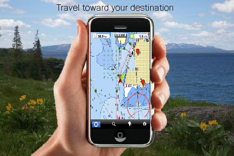
· Use Latitudes and Longitudes to go to your favorite places
· Insert the target/destination 'Waypoint' and see in real time your speed, distance and direction to destination
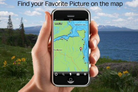
· Insert Unlimited Markers near favorite places on the map
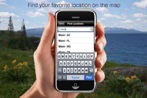
· Search your Favorite points directly
· Zoom, Rotate and Pan fast just by a finger touch
· Navigate and see your GPS position on the map
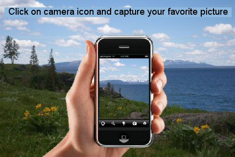
· Geo-Tagged photo management
· Set On/Off Elevation Contours if you feel data is cluttering
What's New in This Release:
· Minor bug fixed
· Retina display management
Like it? Share with your friends!
If you got an error while installing Themes, Software or Games, please, read FAQ.
Supported operating systems:
Apple iOS 10.x (iPad), Apple iOS 10.x (iPhone), Apple iOS 11.x (iPad), Apple iOS 12.x (iPad), Apple iOS 12.x (iPhone), Apple iOS 4.2.x (iPad), Apple iOS 4.2.x (iPhone), Apple iOS 4.2.x (iPod Touch), Apple iOS 4.3.x (iPad), Apple iOS 4.3.x (iPhone), Apple iOS 4.3.x (iPod Touch), Apple iOS 5.0 (iPad), Apple iOS 5.0 (iPhone), Apple iOS 5.0 (iPod Touch), Apple iOS 6.0 (iPad), Apple iOS 6.0 (iPhone), Apple iOS 6.0 (iPod Touch), Apple iOS 7.0 (iPad), Apple iOS 7.0 (iPhone), Apple iOS 7.0 (iPod Touch), Apple iOS 8.x (iPad), Apple iOS 8.x (iPhone), Apple iOS 8.x (iPod Touch), Apple iOS 9.x (iPad), Apple iOS 9.x (iPhone), Apple iOS 9.x (iPod Touch)
Similar Software:
Sygic Turkey: GPS Navigation Sygic Turkey: GPS Navigation - Sygic is a premium turn-by-turn GPS navigation application. Sygic boasts an intuitive interface: drag the map, pinch to zoom, change point of view using built-in compass and tap target square to choose action
Cleveland(Ohio) World Travel Cleveland(Ohio) World Travel - Map with locate me function makes you free to move.
Background reading always accompanies you on your trip
Nav4D Portugal Nav4D Portugal - Single intuitive menu gives the user all the information needed to begin a journey with confidence. Along the way take advantage of the automatic local and global search with rich contents.
Designed to attract everyone, the new interface concept makes usability and design a key point. Nav4D is the perfect navigation system for iPhone
Albuquerque GPS Guide The only thing we do, help you to move freely as an alien, by "Offline" & "GPS"
Find My Friends Find My Friends - Find My Friends allows you to easily locate your friends and family from your iPhone, iPad, or iPod touch. Install this free app on your iOS device and sign in with the Apple ID you use with iCloud. Adding a friend is easy - just send a request to see their location
Azores Islands - GPS Map Navigator Azores Islands - GPS Map Navigator. FlytoMap provides complete, quick and easy to use map applications for navigation for iPhone. Continues in the tradition of offering depth of information and functionality across expected places all over the world, exploring the map you get maximum details obtaining detailed information of every object on the map
Mammoth Cave National Park - GPS Map Navigator Mammoth Cave National Park - GPS Map Navigator - Continues in the tradition of offering depth of information and functionality across expected places all over the world, exploring the map you get maximum details obtaining detailed information of each object on the map
TomTom Mauritius TomTom Mauritius - Get the TomTom navigation app and have smart, easy-to-use, turn-by-turn navigation on your iPhone or iPod touch, whenever and wherever you need it.
And, now, never miss a turn. The new TomTom app guides you even while you are on a call or running a different app on your iPhone
Martinique - GPS Map Navigator Martinique - GPS Map Navigator - FlytoMap provides complete, quick and easy to use map applications for navigation. Continues in the tradition of offering depth of information and functionality across expected places all over the world, exploring the map you get maximum details obtaining detailed information of every object on the map
Nav4D Qatar Nav4D Qatar - Single intuitive menu gives the user all the information needed to begin a journey with confidence. Along the way take advantage of the automatic local and global search with rich contents.
Designed to attract everyone, the new interface concept makes usability and design a key point. Nav4D is the perfect navigation system for iPhone
Lake Powell - Fishing Lake Powell - Fishing - Lake Powell is the ultimate recreational spot for millions of visitors having 186 miles length with 1960 miles of shoreline for excellent activities.
Lake Powell is well known for activities like Swimming, Boating and Kayaking, Fishing, Scuba diving, Snorkeling, Water skiing and sightseeing. Photographic opportunities around are plentiful
Hamburg Wadden Sea National Park - GPS Map Navigator Hamburg Wadden Sea National Park - GPS Map Navigator - FlytoMap provides complete, quick and easy to use map applications for navigation for iPhone. Continues in the tradition of offering depth of information and functionality across expected places all over the world, exploring the map you get maximum details obtaining detailed information of every object on the map
Old Hickory Lake - Fishing Old Hickory Lake - Fishing - Continues in the tradition of offering depth of information and functionality across expected places all over the world, exploring the map you get maximum details obtaining detailed information of each object on the map
US Great Lakes HD - GPS Map Navigator US Great Lakes HD - GPS Map Navigator - FlytoMap provides complete, quick and easy to use map applications for navigation for iPad. Continues in the tradition of offering depth of information and functionality across expected places all over the world, exploring the map you get maximum details obtaining detailed information of every object on the map
Seychelles - GPS Map Navigator Seychelles - GPS Map Navigator - FlytoMap provides complete, quick and easy to use map applications for navigation for iPhone. Continues in the tradition of offering depth of information and functionality across expected places all over the world, exploring the map you get maximum details obtaining detailed information of every object on the map
Brecon Beacons National Park - GPS Map Navigator Brecon Beacons National Park - GPS Map Navigator - FlytoMap provides complete, quick and easy to use map applications for navigation for iPhone. Continues in the tradition of offering depth of information and functionality across expected places all over the world, exploring the map you get maximum details obtaining detailed information of every object on the map
Channel Islands National Park - GPS Map Navigator Channel Islands National Park - GPS Map Navigator - Continues in the tradition of offering depth of information and functionality across expected places all over the world, exploring the map you get maximum details obtaining detailed information of each object on the map
Hohe Tauern National Park - GPS Map Navigator Hohe Tauern National Park - GPS Map Navigator - FlytoMap provides complete, quick and easy to use map applications for navigation for iPhone. Continues in the tradition of offering depth of information and functionality across expected places all over the world, exploring the map you get maximum details obtaining detailed information of every object on the map
Marine: Miami to Key West - GPS Map Navigator Marine: Miami to Key West - GPS Map Navigator - Continues in the tradition of offering depth of information and functionality across expected places all over the world, exploring the map you get maximum details obtaining detailed information of each object on the map

")


 World Travel")


