Platforms: iPhone, iPad, iPod Touch, Apple iPhone OS
Categories: Travel & Navigation
Upload date: 18 Jan 12
Developer: Flytomap
License: Commercial
Price: 2.99 $
Downloads: 36
Harz National Park - flytoMap provides complete, quick and easy to use map applications for navigation for iPhone. Continues in the tradition of offering depth of information and functionality across expected places all over the world, exploring the map you get maximum details obtaining detailed information of every object on the map.
FlytoMap processes different types of maps for navigation for different categories:
WATER MAPS (Marine):
Water map navigator is the new ‘Marine Navigator for iPhone’ contains embedded Electronic Nautical Charts (ENC) from NOAA compressed to a large coverage. You can now download the application and transform your iPhone in a chart plotter with best NOAA, ENC S57 cartography; which includes Anchoring areas, Fishing areas, restriction areas, obstructions, rocks, Buoys, Beacons, Lights, Depth contours with Values display on map, Spot Soundings and more. The only marine app available in the market with such huge information. Every effort is made to be as accurate as possible when presenting information for every destination.
PARK MAPS:
Park map applications are extremely advanced contains embedded electronic charts with all information collected from the National Park Service and local sources. The maps contain all multiple trails (Hiking, biking, Stairway trails, Bicycle trails, Equestrian trails etc.,) and Point of interests (POI) like Campgrounds, Eating places, Ranger Stations, Picnic areas, Boat/Canoe launching, Parking areas etc., which are provided depending on the relevant park areas they exist.
LAKE MAPS:
We offer high quality lake maps with detailed information and important features compressed to assure the larger coverage in USA region. Lake maps contain most important DNR lakes with detailed ‘Depth Contours, Boat Ramps, Fishing spots etc. Also includes Trails, Roads and Railways information.
TRAVEL MAPS:
These Maps treat you mostly with information of both Marine and terrain correspondingly. These are the most preferable Maps to travel especially for fascinating recreational voyages, map focus the best Beach spots along the Coast line, Major ports, Sailing, Fishing, Picnic areas, Parks, Hiking, Biking, Clubs, restaurants, Famous Hotels, Museums, Shopping areas, and much more.
· Use Latitudes and Longitudes to go to your favorite places
· Insert the target/destination ‘Waypoint’ and see in real time your speed, distance and direction to destination
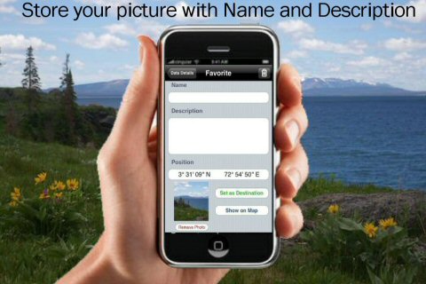
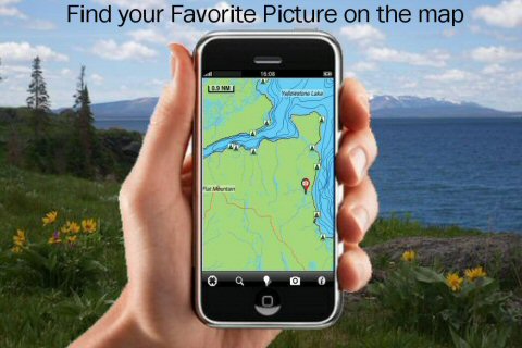
· Insert Unlimited Markers near favorite places on the map
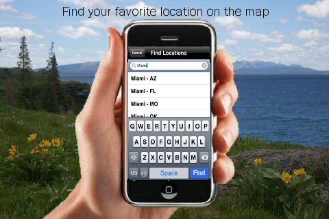
· Search your Favorite points directly
· Zoom, Rotate and Pan fast just by a finger touch
· Navigate and see your GPS position on the map
· Geo-Tagged photo management
· Set On/Off Elevation Contours if you feel data is cluttering
What's New in This Release:
· GPS Info Page
· Faster Names Search
What's New in 2.5.1:
· Minor bug Fixed
What's New in 2.5:
· Fully compatible to 4.0
· Improved GPS management in low signal conditions
· Added direction angle information when navigating toward a destination
Like it? Share with your friends!
If you got an error while installing Themes, Software or Games, please, read FAQ.
Supported operating systems:
Apple iOS 10.x (iPad), Apple iOS 10.x (iPhone), Apple iOS 11.x (iPad), Apple iOS 12.x (iPad), Apple iOS 12.x (iPhone), Apple iOS 4.0.x (iPhone), Apple iOS 4.0.x (iPod Touch), Apple iOS 4.2.x (iPad), Apple iOS 4.2.x (iPhone), Apple iOS 4.2.x (iPod Touch), Apple iOS 4.3.x (iPad), Apple iOS 4.3.x (iPhone), Apple iOS 4.3.x (iPod Touch), Apple iOS 5.0 (iPad), Apple iOS 5.0 (iPhone), Apple iOS 5.0 (iPod Touch), Apple iOS 6.0 (iPad), Apple iOS 6.0 (iPhone), Apple iOS 6.0 (iPod Touch), Apple iOS 7.0 (iPad), Apple iOS 7.0 (iPhone), Apple iOS 7.0 (iPod Touch), Apple iOS 8.x (iPad), Apple iOS 8.x (iPhone), Apple iOS 8.x (iPod Touch), Apple iOS 9.x (iPad), Apple iOS 9.x (iPhone), Apple iOS 9.x (iPod Touch), Apple iPhone OS 3.1.x, Apple iPhone OS 3.1.x (iPod Touch), Apple iPhone OS 3.2.x (iPad)
Similar Software:
Stuttgart (Germany) Map Offline Stuttgart (Germany) Map Offline - This will be perfect when you are traveling and you don't have internet connection. This Offline Maps is not a replacement of Google Maps. It is used when you don't have internet connection and want to use maps
CoPilot Premium France for iOS CoPilot Premium France for iOS - CoPilot is a powerful GPS navigation solution for iPhone, iPad and iPod touch. The app comes with downloadable maps of France, which can be used offline, allowing you to find your way even when you don't have an internet connection
Nav4D Spain Nav4D Spain - Single intuitive menu gives the user all the information needed to begin a journey with confidence. Along the way take advantage of the automatic local and global search with rich contents.
Designed to attract everyone, the new interface concept makes usability and design a key point. Nav4D is the perfect navigation system for iPhone
Cleveland(Ohio) World Travel Cleveland(Ohio) World Travel - Map with locate me function makes you free to move.
Background reading always accompanies you on your trip
GPSMinder GPSMinder allows you to create reminders for yourself based on GPS locations and schedules. GPSMinder also takes advantage of some advanced features in iOS 4.0 to lower battery consumption while the application is in the background
Sygic Colombia: GPS Navigation Sygic Colombia: GPS Navigation - Sygic is a premium turn-by-turn GPS navigation application. Sygic boasts an intuitive interface: drag the map, pinch to zoom, change point of view using built-in compass and tap target square to choose action
CoPilot Live Italy CoPilot Live Italy - Welcome to CoPilot Live, the award winning turn-by-turn iPhone sat navigation app with complete street maps of Italy and door to door voice directions.
CoPilot Live is packed full of advanced navigation features to guide you easily and accurately, including clear 3D map displays, lane indicator arrows and speed limit alerts
Death Valley National Park - GPS Map Navigator Death Valley National Park - GPS Map Navigator continues in the tradition of offering depth of information and functionality across expected places all over the world, exploring the map you get maximum details obtaining detailed information of each object on the map
Barbados GPS Map Barbados GPS Map is a navigation App for the country of Barbados. All application features and map data is stored within your iPhone, allowing you to use the app freely without the worry of expensive data charges. Fast, simple user interface with detailed map data allows you to navigate throughout Barbados using your iPhone
Buenos Aires (Argentina) Map Offline Buenos Aires (Argentina) Map Offline - This will be perfect when you are traveling and you don't have internet connection. This Offline Maps is not a replacement of Google Maps. It is used when you don't have internet connection and want to use maps
Other Software by developer «Flytomap»:
Parco dei Cetacei - (Marine: Mar Ligure) - GPS Map Navigator Parco dei Cetacei - (Marine: Mar Ligure) - GPS Map Navigator - Liguria region is well-known by international travelers from more than a century and have recognized the warmth and beauty of the magnificent Italian Riviera. Best place to enjoy warm water, wide sandy beaches, and posh resorts, discriminating travelers to come and explore
Marine: Hebrides - GPS Map Navigator Marine: Hebrides - GPS Map Navigator - FlytoMap provides complete, quick and easy to use map applications for navigation for iPhone. Continues in the tradition of offering depth of information and functionality across expected places all over the world, exploring the map you get maximum details obtaining detailed information of every object on the map
Lake Texoma - Fishing Lake Texoma - Fishing - Lake Texoma enjoys a well deserved reputation as a major sailing lake.
Texoma is famous for excellent fishing for striped bass and other species. Using our Map will ensure you a professional fishing and a great experience whether you are a novice or a seasoned angler
Theodore Roosevelt National Park - GPS Map Navigator Theodore Roosevelt National Park - GPS Map Navigator - Continues in the tradition of offering depth of information and functionality across expected places all over the world, exploring the map you get maximum details obtaining detailed information of each object on the map
Cuyahoga Valley National Park - GPS Map Navigator Cuyahoga Valley National Park - GPS Map Navigator - Continues in the tradition of offering depth of information and functionality across expected places all over the world, exploring the map you get maximum details obtaining detailed information of each object on the map
Cyclades - GPS Map Navigator Cyclades - GPS Map Navigator - FlytoMap provides complete, quick and easy to use map applications for navigation for iPhone. Continues in the tradition of offering depth of information and functionality across expected places all over the world, exploring the map you get maximum details obtaining detailed information of every object on the map
Superior National Forest - Standard Superior National Forest - Standard - Continues in the tradition of offering depth of information and functionality across expected places all over the world, exploring the map you get maximum details obtaining detailed information of each object on the map
FlyToMap GPS HD - All in One FlyToMap GPS HD - All in One - FlytoMap provides complete, quick and easy to use map applications for navigation for iPad. Continues in the tradition of offering depth of information and functionality across expected places all over the world, exploring the map you get maximum details obtaining detailed information of every object on the map
Cozumel Island - GPS Map Navigator Cozumel Island - GPS Map Navigator - FlytoMap provides complete, quick and easy to use map applications for navigation for iPhone. Continues in the tradition of offering depth of information and functionality across expected places all over the world, exploring the map you get maximum details obtaining detailed information of every object on the map
Arcipelago Toscano National Park - GPS Map Navigator Arcipelago Toscano National Park - GPS Map Navigator - FlytoMap provides complete, quick and easy to use map applications for navigation for iPhone. Continues in the tradition of offering depth of information and functionality across expected places all over the world, exploring the map you get maximum details obtaining detailed information of every object on the map

")


 Map Offline")


 World Travel")


 Map Offline")
 - GPS Map Navigator")


