Hamburg Wadden Sea National Park - GPS Map Navigator
Version: 3.1updated
Platforms: iPhone, iPad, iPod Touch, Apple iPhone OS
Categories: Travel & Navigation
Upload date: 30 Jan 12
Developer: Flytomap
License: Commercial
Price: 2.99 $
Downloads: 20
Hamburg Wadden Sea National Park - GPS Map Navigator - FlytoMap provides complete, quick and easy to use map applications for navigation for iPhone. Continues in the tradition of offering depth of information and functionality across expected places all over the world, exploring the map you get maximum details obtaining detailed information of every object on the map.
FlytoMap processes different types of maps for navigation for different categories:
WATER MAPS (Marine):
Water map navigator is the new ‘Marine Navigator for iPhone’ contains embedded Electronic Nautical Charts (ENC) from NOAA compressed to a large coverage. You can now download the application and transform your iPhone in a chart plotter with best NOAA, ENC S57 cartography; which includes Anchoring areas, Fishing areas, restriction areas, obstructions, rocks, Buoys, Beacons, Lights, Depth contours with Values display on map, Spot Soundings and more. The only marine app available in the market with such huge information. Every effort is made to be as accurate as possible when presenting information for every destination.
PARK MAPS:
Park map applications are extremely advanced contains embedded electronic charts with all information collected from the National Park Service and local sources. The maps contain all multiple trails (Hiking, biking, Stairway trails, Bicycle trails, Equestrian trails etc.,) and Point of interests (POI) like Campgrounds, Eating places, Ranger Stations, Picnic areas, Boat/Canoe launching, Parking areas etc., which are provided depending on the relevant park areas they exist.
LAKE MAPS:
We offer high quality lake maps with detailed information and important features compressed to assure the larger coverage in USA region. Lake maps contain most important DNR lakes with detailed ‘Depth Contours, Boat Ramps, Fishing spots etc. Also includes Trails, Roads and Railways information.
TRAVEL MAPS:
These Maps treat you mostly with information of both Marine and terrain correspondingly. These are the most preferable Maps to travel especially for fascinating recreational voyages, map focus the best Beach spots along the Coast line, Major ports, Sailing, Fishing, Picnic areas, Parks, Hiking, Biking, Clubs, restaurants, Famous Hotels, Museums, Shopping areas, and much more.
· Use Latitudes and Longitudes to go to your favorite places
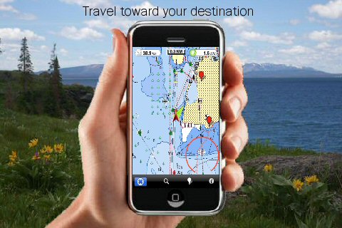
· Insert the target/destination 'Waypoint' and see in real time your speed, distance and direction to destination
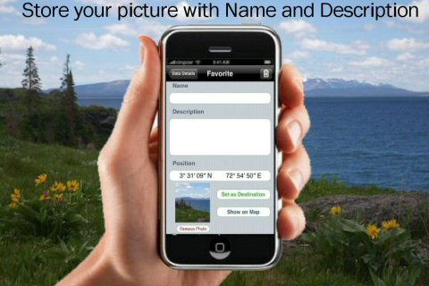
· Insert Unlimited Markers near favorite places on the map
· Search your Favorite points directly
· Zoom, Rotate and Pan fast just by a finger touch
· Navigate and see your GPS position on the map
· Geo-Tagged photo management
· Set On/Off Elevation Contours if you feel data is cluttering
What's New in This Release:
· GPS Info Page
· Faster Names Search
What's New in 2.5.1:
· Minor bug Fixed
Like it? Share with your friends!
If you got an error while installing Themes, Software or Games, please, read FAQ.
Supported operating systems:
Apple iOS 10.x (iPad), Apple iOS 10.x (iPhone), Apple iOS 11.x (iPad), Apple iOS 12.x (iPad), Apple iOS 12.x (iPhone), Apple iOS 4.0.x (iPhone), Apple iOS 4.0.x (iPod Touch), Apple iOS 4.2.x (iPad), Apple iOS 4.2.x (iPhone), Apple iOS 4.2.x (iPod Touch), Apple iOS 4.3.x (iPad), Apple iOS 4.3.x (iPhone), Apple iOS 4.3.x (iPod Touch), Apple iOS 5.0 (iPad), Apple iOS 5.0 (iPhone), Apple iOS 5.0 (iPod Touch), Apple iOS 6.0 (iPad), Apple iOS 6.0 (iPhone), Apple iOS 6.0 (iPod Touch), Apple iOS 7.0 (iPad), Apple iOS 7.0 (iPhone), Apple iOS 7.0 (iPod Touch), Apple iOS 8.x (iPad), Apple iOS 8.x (iPhone), Apple iOS 8.x (iPod Touch), Apple iOS 9.x (iPad), Apple iOS 9.x (iPhone), Apple iOS 9.x (iPod Touch), Apple iPhone OS 3.1.x, Apple iPhone OS 3.1.x (iPod Touch), Apple iPhone OS 3.2.x (iPad)
Similar Software:
Leipzig (Germany) Map Offline Leipzig (Germany) Map Offline - This will be perfect when you are traveling and you don't have internet connection. This Offline Maps is not a replacement of Google Maps. It is used when you don't have internet connection and want to use maps
Barcelona GPS Guide The only thing we do, help you to move freely as an alien, by "Offline" & "GPS"
CoPilot Live Premium Europe HD (iPhone/iPad) CoPilot Live Premium Europe HD (iPhone/iPad) - CoPilot Live Premium HD transforms your 3G iPad into an incredible large-screen in-car sat navigation system.
There's certainly no mistaking the route ahead. CoPilot Live takes full advantage of your iPad's screen to provide easy to follow, crystal clear guidance
Badlands National Park - GPS Map Navigator Badlands National Park - GPS Map Navigator - Continues in the tradition of offering depth of information and functionality across expected places all over the world, exploring the map you get maximum details obtaining detailed information of each object on the map
TomTom Mauritius TomTom Mauritius - Get the TomTom navigation app and have smart, easy-to-use, turn-by-turn navigation on your iPhone or iPod touch, whenever and wherever you need it.
And, now, never miss a turn. The new TomTom app guides you even while you are on a call or running a different app on your iPhone
Sygic France: Navigation GPS Sygic France: Navigation GPS - Sygic is a voice guided GPS navigation application. It's packed with TomTom maps and a robust set of navigation features. Both app and maps are updated for free. Maps are stored on the phone for offline use
TomTom Southern Africa TomTom Southern Africa - Get the TomTom navigation app and have smart, easy-to-use, turn-by-turn navigation on your iPhone or iPod touch, whenever and wherever you need it.
And, now, never miss a turn. The new TomTom app guides you even while you are on a call or running a different app on your iPhone
Ndrive Chile Ndrive Chile - This app will turn your iPhone into a turn by turn voice navigation device.
WHAT YOU ARE BUYING
You are buying a lifetime license of the latest maps. There are no monthly fees or hidden charges.
No data plan is needed to run NDrive software and even when your phone is in roaming, your GPS Navigation from NDrive will run smoothly and uninterupted
North America - iGO primo app North America - iGO primo app - iGO primo app turns your iOS device into a powerful navigation system. Using the same experienced iGO Engine employed by GPS navigation devices all over the world, the app can reliably guide you to your destination in no time.
The software uses accurate offline maps which can be used anywhere
Sequoia - Kings National Park - GPS Map Navigator Sequoia - Kings National Park - GPS Map Navigator - Continues in the tradition of offering depth of information and functionality across expected places all over the world, exploring the map you get maximum details obtaining detailed information of each object on the map
Other Software by developer «Flytomap»:
Arches National Park - Standard Arches National Park - Standard - Continues in the tradition of offering depth of information and functionality across expected places all over the world, exploring the map you get maximum details obtaining detailed information of each object on the map
Sequoia - Kings National Park - Standard Sequoia - Kings National Park - Standard - Continues in the tradition of offering depth of information and functionality across expected places all over the world, exploring the map you get maximum details obtaining detailed information of each object on the map
Antigua - GPS Map Navigator Antigua - GPS Map Navigator - FlytoMap provides complete, quick and easy to use map applications for navigation for iPhone. Continues in the tradition of offering depth of information and functionality across expected places all over the world, exploring the map you get maximum details obtaining detailed information of every object on the map
Eufaula Lake - Fishing Eufaula Lake - Fishing - Lake Eufaula is the largest lake located in the state of Oklahoma. Offers a variety of recreational opportunities for everyone and is a fabulous tourist attraction. The shoreline ranges from vast area of sandy beaches to rocky bluffs
Acadia National Park - GPS Map Navigator Acadia National Park - continues in the tradition of offering depth of information and functionality across expected places all over the world, exploring the map you get maximum details obtaining detailed information of each object on the map
Egadi Islands - GPS Map Navigator Egadi Islands - GPS Map Navigator - Continues in the tradition of offering depth of information and functionality across expected places all over the world, exploring the map you get maximum details obtaining detailed information of each object on the map
Marine: Sydney HD - GPS Map Navigator Marine: Sydney HD - GPS Map Navigator - FlytoMap provides complete, quick and easy to use map applications for navigation for iPad. Continues in the tradition of offering depth of information and functionality across expected places all over the world, exploring the map you get maximum details obtaining detailed information of every object on the map
Harz National Park - GPS Map Navigator Harz National Park - flytoMap provides complete, quick and easy to use map applications for navigation for iPhone. Continues in the tradition of offering depth of information and functionality across expected places all over the world, exploring the map you get maximum details obtaining detailed information of every object on the map
Crater Lake National Park - Standard Crater Lake National Park - Standard - Continues in the tradition of offering depth of information and functionality across expected places all over the world, exploring the map you get maximum details obtaining detailed information of each object on the map
Cuyahoga Valley National Park - Standard Cuyahoga Valley National Park - Standard - Continues in the tradition of offering depth of information and functionality across expected places all over the world, exploring the map you get maximum details obtaining detailed information of each object on the map
Comments on Hamburg Wadden Sea National Park - GPS Map Navigator:
Comments not found
If you noted an error or download link is broken, please, report it via this page or use comments.
Hamburg Wadden Sea National Park - GPS Map Navigator is compatible with your device Apple iPhone 12 Pro 5G A2407 Global Dual SIM TD-LTE 512GB (Apple iPhone 13,3)

")


 Map Offline")

")


