Platforms: iPhone, iPad, iPod Touch, Apple iPhone OS
Categories: Travel & Navigation
Upload date: 6 Feb 12
Developer: Flytomap
License: Commercial
Price: 2.99 $
Downloads: 58
Aaland Islands - GPS Map Navigator - FlytoMap provides complete, quick and easy to use map applications for navigation for iPhone. Continues in the tradition of offering depth of information and functionality across expected places all over the world, exploring the map you get maximum details obtaining detailed information of every object on the map.
FlytoMap processes different types of maps for navigation for different categories:
WATER MAPS (Marine):
Water map navigator is the new ‘Marine Navigator for iPhone’ contains embedded Electronic Nautical Charts (ENC) from NOAA compressed to a large coverage. You can now download the application and transform your iPhone in a chart plotter with best NOAA, ENC S57 cartography; which includes Anchoring areas, Fishing areas, restriction areas, obstructions, rocks, Buoys, Beacons, Lights, Depth contours with Values display on map, Spot Soundings and more. The only marine app available in the market with such huge information. Every effort is made to be as accurate as possible when presenting information for every destination.
PARK MAPS:
Park map applications are extremely advanced contains embedded electronic charts with all information collected from the National Park Service and local sources. The maps contain all multiple trails (Hiking, biking, Stairway trails, Bicycle trails, Equestrian trails etc.,) and Point of interests (POI) like Campgrounds, Eating places, Ranger Stations, Picnic areas, Boat/Canoe launching, Parking areas etc., which are provided depending on the relevant park areas they exist.
LAKE MAPS:
We offer high quality lake maps with detailed information and important features compressed to assure the larger coverage in USA region. Lake maps contain most important DNR lakes with detailed ‘Depth Contours, Boat Ramps, Fishing spots etc. Also includes Trails, Roads and Railways information.
TRAVEL MAPS:
These Maps treat you mostly with information of both Marine and terrain correspondingly. These are the most preferable Maps to travel especially for fascinating recreational voyages, map focus the best Beach spots along the Coast line, Major ports, Sailing, Fishing, Picnic areas, Parks, Hiking, Biking, Clubs, restaurants, Famous Hotels, Museums, Shopping areas, and much more.
· Use Latitudes and Longitudes to go to your favorite places
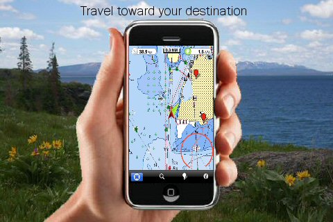
· Insert the target/destination 'Waypoint' and see in real time your speed, distance and direction to destination
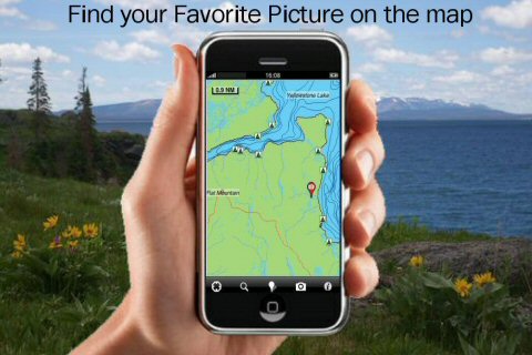
· Insert Unlimited Markers near favorite places on the map
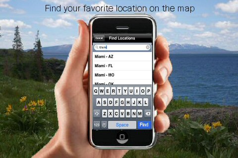
· Search your Favorite points directly
· Zoom, Rotate and Pan fast just by a finger touch
· Navigate and see your GPS position on the map
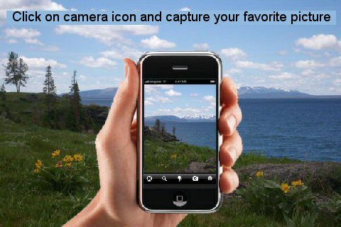
· Geo-Tagged photo management
· Set On/Off Elevation Contours if you feel data is cluttering
What's New in This Release:
· Fixed bug on Favorites and Camera management
What's New in 3.2.2:
· Added the link to the NOAA buoys in the application console.
What's New in 3.1:
· GPS Info Page
· Faster Names Search
Like it? Share with your friends!
If you got an error while installing Themes, Software or Games, please, read FAQ.
Supported operating systems:
Apple iOS 10.x (iPad), Apple iOS 10.x (iPhone), Apple iOS 11.x (iPad), Apple iOS 12.x (iPad), Apple iOS 12.x (iPhone), Apple iOS 4.0.x (iPhone), Apple iOS 4.0.x (iPod Touch), Apple iOS 4.2.x (iPad), Apple iOS 4.2.x (iPhone), Apple iOS 4.2.x (iPod Touch), Apple iOS 4.3.x (iPad), Apple iOS 4.3.x (iPhone), Apple iOS 4.3.x (iPod Touch), Apple iOS 5.0 (iPad), Apple iOS 5.0 (iPhone), Apple iOS 5.0 (iPod Touch), Apple iOS 6.0 (iPad), Apple iOS 6.0 (iPhone), Apple iOS 6.0 (iPod Touch), Apple iOS 7.0 (iPad), Apple iOS 7.0 (iPhone), Apple iOS 7.0 (iPod Touch), Apple iOS 8.x (iPad), Apple iOS 8.x (iPhone), Apple iOS 8.x (iPod Touch), Apple iOS 9.x (iPad), Apple iOS 9.x (iPhone), Apple iOS 9.x (iPod Touch)
Similar Software:
TomTom Benelux TomTom Benelux - Get the TomTom navigation app and have smart, easy-to-use, turn-by-turn navigation on your iPhone or iPod touch, whenever and wherever you need it.
And, now, never miss a turn. The new TomTom app guides you even while you are on a call or running a different app on your iPhone
NAVIGON MobileNavigator EU 10 NAVIGON MobileNavigator EU 10 - With the NAVIGON MobileNavigator you can transform your iPhone into a fully functional mobile navigation system that is every bit as good as the multi-award-winning personal navigation devices from NAVIGON in terms of its user-friendliness and features
Navfree GPS Live Spain Navfree GPS Live Spain - Navfree is a free GPS navigation solution for iOS devices. The app uses OpenStreetMap data, created and updated by thousands of users from all over the world.
The maps are stored locally on the device, so there is no need for a data connection
Ndrive Spain Ndrive Spain - This app will turn your iPhone into a turn by turn voice navigation device.
WHAT YOU ARE BUYING
You are buying a lifetime license of the latest maps. There are no monthly fees or hidden charges.
No data plan is needed to run NDrive software and even when your phone is in roaming, your GPS Navigation from NDrive will run smoothly and uninterupted
Apostle Islands National Lakeshore - GPS Map Navigator Apostle Islands National Lakeshore - GPS Map Navigator - Continues in the tradition of offering depth of information and functionality across expected places all over the world, exploring the map you get maximum details obtaining detailed information of each object on the map
Israel - iGO primo app Israel - iGO primo app - iGO primo app turns your iOS device into a powerful navigation system. Using the same experienced iGO Engine employed by GPS navigation devices all over the world, the app can reliably guide you to your destination in no time.
The software uses accurate offline maps which can be used anywhere
Malta - GPS Map Navigator Malta - GPS Map Navigator - FlytoMap provides complete, quick and easy to use map applications for navigation. Continues in the tradition of offering depth of information and functionality across expected places all over the world, exploring the map you get maximum details obtaining detailed information of every object on the map
Nav4D Balkan (LOW COST) Nav4D Balkan (LOW COST) - The first **low cost** application!
Don't waste your money!
Why pay for lifetime if you only need it for a limited time??
Nav4D is highly innovative at a very low price.
Nav4D is a high-end GPS navigator. It brings a new look to users mobility interaction. Turn by turn directions
CoPilot Premium Europe for iPhone CoPilot Premium Europe for iPhone - CoPilot is a powerful GPS navigation solution for iPhone and iPod touch. The app comes with downloadable maps of Western and Eastern Europe, which can be used offline, allowing you to find your way even when you don't have an internet connection
Long Beach Maps Offline Long Beach Maps Offline - This will be perfect when you are traveling and you don't have internet connection. This Offline Maps is not a replacement of Google Maps. It is used when you don't have internet connection and want to use maps
Other Software by developer «Flytomap»:
Hamburg Wadden Sea National Park - GPS Map Navigator Hamburg Wadden Sea National Park - GPS Map Navigator - FlytoMap provides complete, quick and easy to use map applications for navigation for iPhone. Continues in the tradition of offering depth of information and functionality across expected places all over the world, exploring the map you get maximum details obtaining detailed information of every object on the map
Antigua - GPS Map Navigator Antigua - GPS Map Navigator - FlytoMap provides complete, quick and easy to use map applications for navigation for iPhone. Continues in the tradition of offering depth of information and functionality across expected places all over the world, exploring the map you get maximum details obtaining detailed information of every object on the map
Lake Powell - Fishing Lake Powell - Fishing - Lake Powell is the ultimate recreational spot for millions of visitors having 186 miles length with 1960 miles of shoreline for excellent activities.
Lake Powell is well known for activities like Swimming, Boating and Kayaking, Fishing, Scuba diving, Snorkeling, Water skiing and sightseeing. Photographic opportunities around are plentiful
Cape Cod National Seashore - GPS Map Navigator Cape Cod National Seashore - GPS Map Navigator - Continues in the tradition of offering depth of information and functionality across expected places all over the world, exploring the map you get maximum details obtaining detailed information of each object on the map
Rocky Mountain National Park - Standard Rocky Mountain National Park - Standard - Continues in the tradition of offering depth of information and functionality across expected places all over the world, exploring the map you get maximum details obtaining detailed information of each object on the map
Singapore - GPS Map Navigator Singapore - GPS Map Navigator - FlytoMap provides complete, quick and easy to use map applications for navigation. Continues in the tradition of offering depth of information and functionality across expected places all over the world, exploring the map you get maximum details obtaining detailed information of every object on the map
Hunting Map - Pennsylvania Hunting Map - Pennsylvania - iHunt - Pennsylvania is the best hunting map product available today on the market.
You can Navigate in real time looking your position on the map, you don't need internet connection, switch off the 3G and double your iPhone battery life.
It is a collection of the best hunting maps available for Pennsylvania
Marine:Arcipelago Toscano Marine:Arcipelago Toscano - FlytoMap provides innovative Marine Maps and outstanding technological support to all mariners.
Map Functionality and ease of use is the primary goal of FlytoMap when designing the for best water experiences.
Map contains embedded electronic charts with huge coverage of data
Shenandoah National Park - GPS Map Navigator Shenandoah National Park - GPS Map Navigator - Continues in the tradition of offering depth of information and functionality across expected places all over the world, exploring the map you get maximum details obtaining detailed information of each object on the map
Costa Brava - GPS Map Navigator Costa Brava - GPS Map Navigator - FlytoMap provides complete, quick and easy to use map applications for navigation for iPhone. Continues in the tradition of offering depth of information and functionality across expected places all over the world, exploring the map you get maximum details obtaining detailed information of every object on the map

")


")


