Platforms: iPhone, iPad, iPod Touch, Apple iPhone OS
Categories: Travel & Navigation
Upload date: 28 Mar 12
Developer: Fugawi Software
License: Commercial
Price: 149.99 $
Downloads: 26
Fugawi iMap: Sweden Entire Country - Fugawi iMap: Sweden Entire Country is a Topo Map application of Sweden for iPhone. It is great for going off-road and into the back country. For those who prefer a lower Price, the App is also sold in 4 regions of Sweden.
Features:
=> All of Sweden Included...
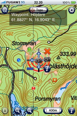
The only Topo App to include all of Sweden! Included Scales: Terrängkartan 1:50,000, Fjällkartan/Vägkartan 1:100,000, Översiktskartan 1:250,000, Sverigekartan 1:700,000
=> Seamless Maps...
Seamlessly loads raster topographic maps via the iPhone internet connection and caches them in memory for use when outdoors and not in 3G, EDGE or WiFi coverage.
=> Satellite Photo Maps...
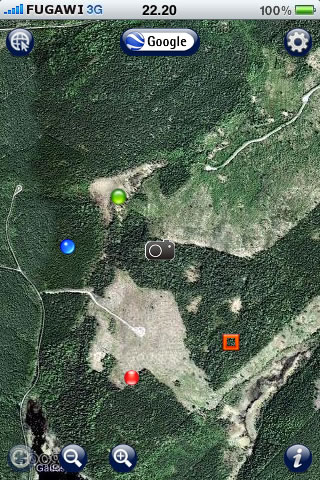
Swap between topo map and Google Maps view with a single tap. Use anywhere in the world with satellite maps. Create, view and edit waypoints and photo waypoints on the included topo map or Google Maps. Choose between street map, satellite map or hybrid (street + satellite) view.
=> Easiest Waypoint Editor Ever...
Tap and hold on the screen to drop waypoints which may be custom edited by name, icon, precise co-ordinates, and text description. Easily move waypoints with a simple tap and drag.
==> GPS Photo Waypoints...
Tap to create a photo using the iPhone camera or select an image from the photo library.
==> X-Traverse Facebook App...
Send any waypoint or photo waypoint to your Facebook account. The waypoint and associated photo will appear in your Facebook account on an interactive map to share with your friends. Requires installation of the free X-Traverse Facebook App from x-traverse.com/facebook.
=> FREE Online Waypoint Storage and backup...
Waypoints can be transferred directly to your free account at X-Traverse.com which is included with your purchase of Fugawi iMap.To set up your account, launch iMap and select Settings|X-Traverse Account|Create X-Traverse Account.
=> Location in Lat/Long or UTM...
Pinpoint your current location, shown in latitude/longitude or UTM, with an easily visible position marker.
=> Map Pans as You Move...
Seamless map moves as you move.
=> Zoom In / Out...
Zoom in or out of the entire available map collection.
=> Download All Scales
Download all maps at all scales within 1, 5 or 10 km (or miles) of the screen center. Downloaded maps are saved to an auto-managed memory in the iPhone for fast retrieval on subsequent views or for use when outside of 3G, Edge or Wi-Fi internet coverage.
=> Map Details...
See details such as scale, elevation contours, water bodies, major roads, railways, bridges, urban land use, and more.
Technical Details:
=> Terrängkartan 1:50,000, Fjällkartan/Vägkartan 1:100,000, Översiktskartan 1:250,000, Sverigekartan 1:700,000 included.
=> Import and export waypoints as industry standard GPX files using the Fugawi X-Traverse web server (account included with App purchase). Use the GPX files on your computer with any software (such as Fugawi Global Navigator) which can import GPX data. Most iPhone Apps do not have this very helpful feature.
=> Topographic maps are delivered from Fugawi X-Traverse via the iPhone internet connection which then caches them in memory for use when outdoors and not in 3G, EDGE or WiFi coverage.
=> The iPhone location services are enabled for auto-selection of the map appropriate for your location, displaying your location in real-time with a easily visible marker. Spot elevation and direction of travel are also displayed when these location services are available to your iPhone model (e.g. iPhone 3G or 3GS).
=> The interface follows best practices for iPhone software: intuitive, simple to use, web connected.
What's New in This Release:
· Support for iOS 5.1
· Added range and bearing to/from GPS position to waypoint tool
What's New in 3.2.00:
Track Recording:
· Tracks may now be recorded.
· Control the line style of each track and hide/show tracks.
· Send tracks to your X-Traverse account or upload to Facebook with one tap.
Fast Photo Waypoints:
· New camera icon on the screen to instantly create a photo waypoint.
· Photo waypoints created this way are associated with the active track.
· Uploaded to Facebook with the associated track with one tap.
Supports Screen Rotation:
· Supports landscape/portrait rotation on iPhone and iPad.
Position Centering:
· In Settings, you can now choose to center your location at middle of screen, or allow your position to move to edge of screen before re-centering.
Optimized for iOS 4:
· Supports multi-tasking of iOS 4.
Default Waypoints:
· Added user control for default waypoint and track symbols and line types.
Bug Fixes:
· Much improvement to stability of Google Maps interface.
Like it? Share with your friends!
If you got an error while installing Themes, Software or Games, please, read FAQ.
Supported operating systems:
Apple iOS 10.x (iPad), Apple iOS 10.x (iPhone), Apple iOS 11.x (iPad), Apple iOS 12.x (iPad), Apple iOS 12.x (iPhone), Apple iOS 4.0.x (iPhone), Apple iOS 4.0.x (iPod Touch), Apple iOS 4.2.x (iPad), Apple iOS 4.2.x (iPhone), Apple iOS 4.2.x (iPod Touch), Apple iOS 4.3.x (iPad), Apple iOS 4.3.x (iPhone), Apple iOS 4.3.x (iPod Touch), Apple iOS 5.0 (iPad), Apple iOS 5.0 (iPhone), Apple iOS 5.0 (iPod Touch), Apple iOS 6.0 (iPad), Apple iOS 6.0 (iPhone), Apple iOS 6.0 (iPod Touch), Apple iOS 7.0 (iPad), Apple iOS 7.0 (iPhone), Apple iOS 7.0 (iPod Touch), Apple iOS 8.x (iPad), Apple iOS 8.x (iPhone), Apple iOS 8.x (iPod Touch), Apple iOS 9.x (iPad), Apple iOS 9.x (iPhone), Apple iOS 9.x (iPod Touch), Apple iPhone OS 3.1.x, Apple iPhone OS 3.1.x (iPod Touch), Apple iPhone OS 3.2.x (iPad)
Similar Software:
Edinburgh Mini A-Z Edinburgh Mini A-Z - This street map of Edinburgh covers an area extending to Cramond, Granton, Leith, Portobello, Musselburgh, Whitecraig, Dalkeith, Bonnyrigg (part), Loanhead, Fairmilehead, Juniper Green, Currie, Balerno, and Edinburgh Airport.
Major buildings are colour-coded to indicate places of interest and other buildings that are open to the public
Shanghai Street Map Offline Shanghai Street Map Offline - You don't need to have internet connection for this to work as the map is stored on your iPhone or iPod Touch. Ideal for saving roaming charges or having to find the local wifi to access the built-in map application
Prague Travel Guide by Triposo Prague Travel Guide by Triposo - Free interactive travel guide to Prague. Works offline and has a detailed map.
About our guide
We make great, interactive travel guides.
To make our guides we use the content that is freely available. Open content sites like Wikitravel, Wikipedia, World66 and Openstreetmap are among the best resources for any traveler
The Dealmap The Dealmap app is the most comprehensive source for people to find and share the hottest local deals, coupons and discounts, and the only app that aggregates local daily deals in one place. Available throughout the U.S. and U.K., The Dealmap aggregates more than 350,000 local deals, including special offers from nearly 100 popular local daily deal sources
Cape Town Street Map Offline Cape Town Street Map Offline - You don't need to have internet connection for this to work as the map is stored on your iPhone or iPod Touch. Ideal for saving roaming charges or having to find the local wifi to access the built-in map application.
What's New in This Release:
· iOS 5 compatibility changes.
· Further bug fixes and improvements
Free City Maps and Walks (470+ Cities) Free City Maps and Walks (470+ Cities) - This application offers a collection of free off-line city maps and self-guided walking tours for over 470 cities worldwide. This app works without the internet connection or data plan so you do not need to pay roaming charges when traveling to foreign cities.
This revolutionary application makes tour bus obsolete
NAVIGON help2park With NAVIGON help2park, you can find all the possible parking spaces in the surrounding area based on your GPS position – clearly laid out, with an address and telephone number (where available)
Taipei Offline Street Map Taipei Offline Street Map - You don't need to have internet connection for this to work as the map is stored on your iPhone or iPod Touch. Ideal for saving roaming charges or having to find the local wifi to access the built-in map application.
What's New in This Release:
· iOS 5 compatibility changes.
· Further bug fixes and improvements
FlightTrack Pro FlightTrack Pro - the best flight tracking app out there. Get push alerts, real-time flight itinerary updates, automatic synching, and beautiful, zoomable maps that work offline. Flight cancelled? It will even help you find alternate flights.
FlightTrack Pro works seamlessly with TripIt. Forward your airline confirmation emails to plans@tripit
Innsbruck Walking Tours and Map This application presents you several self-guided walking tours to see the best of the city, and it comes with detailed tour route maps and powerful navigation features to guide you from one sight to the next
Other Software by developer «Fugawi Software»:
Fugawi iMap: Germany Topo Maps Fugawi iMap: Germany Topo Maps - Topo Map application of Germany for iPhone.
Features:
=> All of Germany included. Includes 1:25,000, 1:50,000 and 1:200,000 scale topo maps for all of Germany from the Federal Agency for Cartography and Geodesy (Bundesamt für Kartographie und Geodäsie)
=> Seamless Maps..
Fugawi iMap: Sweden SV-3 Sodra Norrland Fugawi iMap: Sweden SV-3 Sodra Norrland - "Fugawi iMap: Sweden SV-3 Sodra Norrland" is a topographic mapping Application of part of Sweden. It is great for going off-road and into the back country. Those who prefer the entire country of Sweden in a single App should purchase "Fugawi iMap: Sweden Entire Country"
Fugawi iMap: Sweden SV-4 Norra Norrland Fugawi iMap: Sweden SV-4 Norra Norrland - "Fugawi iMap: Sweden SV-4 Norra Norrland" is a topographic mapping App of part of Sweden. It is great for going off-road and into the back country. Those who prefer the entire country of Sweden in a single App should purchase "Fugawi iMap: Sweden Entire Country".
Features:
=> 1/4 of Sweden Included..
Fugawi iMap: USA & Canada Topo Maps Fugawi iMap: USA & Canada Topo Maps - Fugawi iMap: USA and Canada brings topo maps to your iPhone. It is great for hikers, boaters, anglers, educators, or anyone going off-road and into the back country. Now includes one-tap "instant swap" between Topo Map view and Google Maps view within the application.
Features:
=> USA and Canada Topos Included..
Fugawi iMap: Sweden SV-2 Svealand Fugawi iMap: Sweden SV-2 Svealand - "Fugawi iMap: Sweden SV-2 Svealand" is a topographic mapping Application of part of Sweden. It is great for going off-road and into the back country. Those who prefer the entire country of Sweden in a single App should purchase "Fugawi iMap: Sweden Entire Country".
Features:
=> 1/4 of Sweden Included..
Fugawi iMap: Sweden SV-1 Gotaland Fugawi iMap: Sweden SV-1 Gotaland - "Fugawi iMap: Sweden SV-1 Gotaland" is a topographic mapping Application of part of Sweden. It is great for going off-road and into the back country. Those who prefer the entire country of Sweden in a single App should purchase "Fugawi iMap: Sweden Entire Country".
Features:
=> 1/4 of Sweden Included..

")


")


