Platforms: iPhone, iPad, iPod Touch, Apple iPhone OS
Categories: Travel & Navigation
Upload date: 15 Oct 12
Developer: Garmin
License: Freeware
Downloads: 69
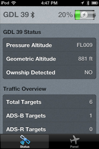
Garmin GDL 39 Utility - Garmin GDL 39 Utility is a companion app for the GDL 39 Portable ADS-B Receiver. It allows you to update your GDL 39 firmware using your iOS device.
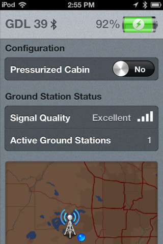
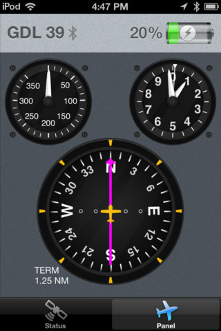
The application also shows the signal strength, ground station status and battery life of GDL 39. In addition, it includes a navigation panel, which displays altimeter, heading and ground speed.
What's New in This Release:
· iOS 6 Compatibility
· Minor bug fixes
Like it? Share with your friends!
If you got an error while installing Themes, Software or Games, please, read FAQ.
Supported operating systems:
Apple iOS 10.x (iPad), Apple iOS 10.x (iPhone), Apple iOS 11.x (iPad), Apple iOS 12.x (iPad), Apple iOS 12.x (iPhone), Apple iOS 5.0 (iPad), Apple iOS 5.0 (iPhone), Apple iOS 5.0 (iPod Touch), Apple iOS 6.0 (iPad), Apple iOS 6.0 (iPhone), Apple iOS 6.0 (iPod Touch), Apple iOS 7.0 (iPad), Apple iOS 7.0 (iPhone), Apple iOS 7.0 (iPod Touch), Apple iOS 8.x (iPad), Apple iOS 8.x (iPhone), Apple iOS 8.x (iPod Touch), Apple iOS 9.x (iPad), Apple iOS 9.x (iPhone), Apple iOS 9.x (iPod Touch)
Similar Software:
Oxnard (CA, USA) Map Offline Oxnard (CA, USA) Map Offline - This will be perfect when you are traveling and you don't have internet connection. This Offline Maps is not a replacement of Google Maps. It is used when you don't have internet connection and want to use maps
Augsburg (Germany) Map Offline Augsburg (Germany) Map Offline - This will be perfect when you are traveling and you don't have internet connection. This Offline Maps is not a replacement of Google Maps. It is used when you don't have internet connection and want to use maps
Nav4D Croatia Nav4D Croatia - Single intuitive menu gives the user all the information needed to begin a journey with confidence. Along the way take advantage of the automatic local and global search with rich contents.
Designed to attract everyone, the new interface concept makes usability and design a key point. Nav4D is the perfect navigation system for iPhone
Isola del Giglio - GPS Map Navigator Isola del Giglio - GPS Map Navigator - FlytoMap provides complete, quick and easy to use map applications for navigation. Continues in the tradition of offering depth of information and functionality across expected places all over the world, exploring the map you get maximum details obtaining detailed information of every object on the map
OpenMaps Pro OpenMaps Pro - Browse the maps of OpenStreetMap (OpenStreetMap, OpenCycleMap, OpenPisteMap), download them for offline use, edit the maps (tag editing and node creation), find out where you are, search for addresses, get directions and scan the map for tweets with OpenMaps for iPhone, iPod touch and iPad.
· Pinpoint your location on the map with a tap of a button
Indiana Dunes National Park - GPS Map Navigator Indiana Dunes National Park - GPS Map Navigator - Continues in the tradition of offering depth of information and functionality across expected places all over the world, exploring the map you get maximum details obtaining detailed information of each object on the map
Dartmoor National Park - GPS Map Navigator Dartmoor National Park - GPS Map Navigator - FlytoMap provides complete, quick and easy to use map applications for navigation for iPhone. Continues in the tradition of offering depth of information and functionality across expected places all over the world, exploring the map you get maximum details obtaining detailed information of every object on the map
New River Gorge National River - GPS Map Navigator New River Gorge National River - GPS Map Navigator - Continues in the tradition of offering depth of information and functionality across expected places all over the world, exploring the map you get maximum details obtaining detailed information of each object on the map
NAVIGON MobileNavigator Mexico NAVIGON MobileNavigator Mexico - With the NAVIGON MobileNavigator you can transform your iPhone into a fully functional mobile navigation system that is every bit as good as the multi-award-winning personal navigation devices from NAVIGON in terms of its user-friendliness and features
Copenhagen (Denmark) Maps Offline Copenhagen (Denmark) Maps Offline - This will be perfect when you are traveling and you don't have internet connection. This Offline Maps is not a replacement of Google Maps. It is used when you don't have internet connection and want to use maps
Other Software by developer «Garmin»:
Garmin Fit for Android Garmin Fit for Android - Garmin Fit allows you to use your Android smartphone as a fitness assistant for tracking your outdoor activities. Whether you are cycling, running or simply walking, the app will show you useful information like speed, distance, route and calories burned
OpenCaching (Android) OpenCaching (Android) is the official geocaching app for OpenCaching.com, a geocaching community powered by the user, for the user. With this app, you get the full OpenCaching.com experience right in the palm of your hands. Easily find, hide, log and share caches right from your Android device
BaseCamp Mobile BaseCamp Mobile - BaseCamp Mobile is a companion app for the Garmin fenix GPS watch. It allows you to wirelessly download data from your watch to the iPhone.
Downloaded data can be used to view routes and tracks on a map. Very useful for recording and reviewing your outdoor activities
Garmin Taiwan Garmin Taiwan - Garmin StreetPilot is a powerful GPS navigation solution for iOS devices. It comes preloaded with the latest map of Taiwan, including over 250,000 points of interest.
Garmin Street offers many useful features, such as turn-by-turn directions, photo-realistic junction views, 3D buildings, exit services, speed cameras, and more
Garmin China Garmin China - Garmin StreetPilot is a powerful GPS navigation solution for iOS devices. It comes preloaded with the latest maps of China, Hong Kong and Macau.
Garmin Street offers many useful features, such as turn-by-turn directions, photo-realistic junction views, 3D buildings, exit services, speed cameras, and more
Garmin Voice Studio Garmin Voice Studio - Customize your Garmin-Asus phone with turn-by-turn voice directions from family and friends.
Easily create and edit Garmin navigation prompts in many languages on your phone. Share your voices with others with Garmin-Asus phones as well as Garmin nüvis.
It's a great way to add some more personality to your Android phone
Garmin StreetPilot onDemand Garmin StreetPilot onDemand brings the power of Garmin navigation to your iPhone with rich navigation features for walking or driving, a simple and intuitive user interface, and an amazingly low price. Using your data connection, StreetPilot onDemand always has access to the most up-to-date maps for the U.S
Garmin GTN Trainer Garmin GTN Trainer - The Garmin GTN 750 Trainer allows you to experience the pilot interface and provide an on-the-ground environment to learn the basic operation of the avionics
Garmin SG/MY Garmin SG/MY - Garmin StreetPilot is a powerful GPS navigation solution for iOS devices. It comes preloaded with the latest maps of Singapore, Malaysia and Brunei.
Garmin Street offers many useful features, such as turn-by-turn directions, photo-realistic junction views, 3D buildings, exit services, speed cameras, and more
Garmin Mechanic Garmin Mechanic - Get insight into how your car is performing with the free Garmin Mechanic application. Use the Skidpad to measure lateral acceleration, and track your speed and distance using GPS.
Taking a trip? Garmin Mechanic tracks your trips and calculates total distance, average speed, and estimated mileage to help increase fuel savings

")


 Map Offline")
 Map Offline")


 Maps Offline")

")


