Platforms: iPhone, iPad, iPod Touch, Apple iPhone OS
Categories: Travel & Navigation
Upload date: 9 Jul 13
Developer: Fasterre services-conseils inc.
License: Commercial
Price: 49.99 $
Downloads: 31
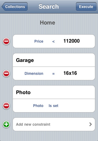
Terrapad Pro gives you the flexibility to enter, query, modify and export your geographic data, all from within your iPad, iPhone or iPod Touch. Driven by a powerful database engine, a unique and simple user interface, and flexible extensions, Terrapad can meet your most demanding needs.
Simple, yet powerful.
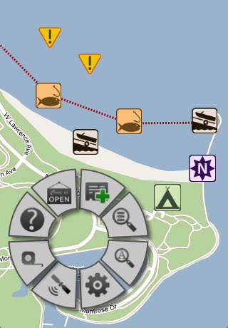
We've designed the Terrapad interface around what's most important: your data. That's why Terrapad's map takes up the entire screen. Without any distraction or interface clutter, you're free to pan around and zoom using standard gestures.
Infinitely extensible.
Extensions are to Terrapad what Apps are to iDevices. By installing extensions, Terrapad may be configured to allow you to enter different types of information. Whether you're a bird watcher, a fishing afficionado or a frequent traveler, there's an extension made just for you.
We regularly publish new extensions to fit the needs of our users. However, if you need an extension that isn't yet available, let us know how we can help.
Perfectly integrated.
Terrapad takes advantage of every feature of your iDevice: from using your device's GPS to sending email and browsing the web without ever leaving the application. Photos and audio recordings can be associated to your data, there's no need to type when you're out in the field!
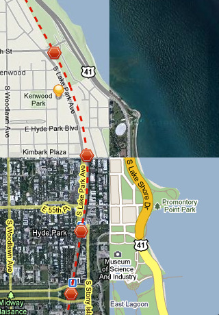
Calls can be made simply by tapping a phone number field and directions are always available through the Maps Application.
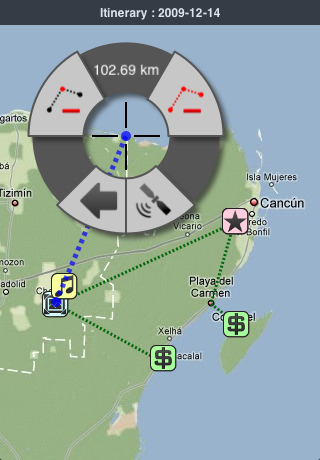
Terrapad can also export your information as KML files for viewing in Google Earth on your computer or as CSV files for manipulation in spreadsheets and databases.
Survey. Touch. Connect.
Terrapad has the ability to synchronize data between multiple devices within your organization.
Synchronization is a seamless, non-intrusive background process that happens behind the scenes while you are collecting data. Your modifications are sent over-the-air to the other devices sharing your extension, while you will receive everything your co-workers have been collecting.
Pro VS Lite
Terrapad is available in two flavours. The lite version if free and ad-supported while the pro version is paying and ad-free. The pro version is also more feature-packed allowing Shapefile import and export, GPS tracking, spatial queries, detailed information about geometries and a host of other features. All extensions are free in Terrapad Pro.
Note: the GPS tracking function, when activated, will cause the GPS radio to stay on, even when Terrapad is running in the background. Continued use of GPS running in the background can dramatically decrease battery life.
What's New in This Release:
· Addressed a critical bug that would prevent extensions from being backed up via iTunes or iCloud.
What's New in 4.1:
· Restored support for jumping to a feature's location in an external mapping application (Google Maps and Apple Maps are currently supported)
· Added a button to control linking and unlinking Terrapad and Dropbox via the Wheel's "Application Tools" menu
· Files containing exported SHP data will now have the extension ".zip.terrapadSHPData" (they are regular zip files)
· Resolved a problem when editing an attribute of type list that has no default value and no empty value
What's New in 3.6.2:
· Updated KML export to be compatible with latest version of Google Earth.
What's New in 3.6.1:
· Minor changes to improve overall application stability.
What's New in 3.6:
· Added support for Open Street Map
· iOS 5 Compatibility
What's New in 3.5.2:
· Fixed a bug introduced in version 3.5 when zooming to Terrapad features
Like it? Share with your friends!
If you got an error while installing Themes, Software or Games, please, read FAQ.
Supported operating systems:
Apple iOS 10.x (iPad), Apple iOS 10.x (iPhone), Apple iOS 11.x (iPad), Apple iOS 12.x (iPad), Apple iOS 12.x (iPhone), Apple iOS 4.0.x (iPhone), Apple iOS 4.0.x (iPod Touch), Apple iOS 4.2.x (iPad), Apple iOS 4.2.x (iPhone), Apple iOS 4.2.x (iPod Touch), Apple iOS 4.3.x (iPad), Apple iOS 4.3.x (iPhone), Apple iOS 4.3.x (iPod Touch), Apple iOS 5.0 (iPad), Apple iOS 5.0 (iPhone), Apple iOS 5.0 (iPod Touch), Apple iOS 6.0 (iPad), Apple iOS 6.0 (iPhone), Apple iOS 6.0 (iPod Touch), Apple iOS 7.0 (iPad), Apple iOS 7.0 (iPhone), Apple iOS 7.0 (iPod Touch), Apple iOS 8.x (iPad), Apple iOS 8.x (iPhone), Apple iOS 8.x (iPod Touch), Apple iOS 9.x (iPad), Apple iOS 9.x (iPhone), Apple iOS 9.x (iPod Touch), Apple iPhone OS 3.1.x, Apple iPhone OS 3.1.x (iPod Touch), Apple iPhone OS 3.2.x (iPad)
Similar Software:
Navfree GPS Live Norway Navfree GPS Live Norway - Navfree is a free GPS navigation solution for iOS devices. The app uses OpenStreetMap data, created and updated by thousands of users from all over the world.
The maps are stored locally on the device, so there is no need for a data connection
NAVIGON EU 10 NAVIGON EU 10 - With the NAVIGON MobileNavigator you can transform your iPhone into a fully functional mobile navigation system that is every bit as good as the multi-award-winning personal navigation devices from NAVIGON in terms of its user-friendliness and features
Los Angeles Maps Offline Los Angeles Maps Offline - This will be perfect when you are traveling and you don't have internet connection. This Offline Maps is not a replacement of Google Maps. It is used when you don't have internet connection and want to use maps
NAVIGON U.S. West for iPhone/iPad 2.7. NAVIGON U.S. West for iPhone/iPad 2.7. - NAVIGON U.S. West turns your iPhone or iPad into a fully featured GPS navigation system. The software provides advanced functionality for both drivers and pedestrians, including 2D and 3D maps, route planner, speed alerter, lane assistant, voice directions, local search, weather conditions and many others.
NAVIGON U.S
Google Latitude With Google Latitude, see where your friends are right now. Google Latitude lets you stay in touch with your friends and family by making it easy to share where you are and see each other on a map.
With Google Latitude, you can:
• See your friends on a map – find out who’s nearby and meet up
CoPilot Live Premium DACH CoPilot Live Premium DACH is the essential voice-guided sat navigation app to get you where you need to go, by the way that suits you best.
Detailed street maps of DACH (Germany, Austria and Switzerland) are stored on-board your iPhone so you don’t need to rely on your mobile connection for navigation or worry about losing directions in coverage dead spots
Dearborn(Michigan) World Travel Dearborn(Michigan) World Travel - Map with locate me function makes you free to move.
Background reading always accompanies you on your trip
Luxembourg City Map Offline Luxembourg City Map Offline - This will be perfect when you are traveling and you don't have internet connection. This Offline Maps is not a replacement of Google Maps. It is used when you don't have internet connection and want to use maps
Barbados - GPS Map Navigator Barbados - GPS Map Navigator. FlytoMap provides complete, quick and easy to use map applications for navigation for iPhone. Continues in the tradition of offering depth of information and functionality across expected places all over the world, exploring the map you get maximum details obtaining detailed information of every object on the map
Utrecht (Netherland) Map Offline Utrecht (Netherland) Map Offline - This will be perfect when you are traveling and you don't have internet connection. This Offline Maps is not a replacement of Google Maps. It is used when you don't have internet connection and want to use maps
Other Software by developer «Fasterre services-conseils inc.»:
Terrapad Lite Terrapad Lite - Terrapad gives you the flexibility to enter, query, modify and export your geographic data, all from within your iPad, iPhone or iPod Touch. Driven by a powerful database engine, a unique and simple user interface, and flexible extensions, Terrapad can meet your most demanding needs.
Simple, yet powerful

")


 World Travel")


 Map Offline")
