Buy Apple iPhone 11 Pro Max A2220 Dual SIM TD-LTE CN 512GB (Apple iPhone 12,5) Parque Nacional Maritimo-Terrestre de Las Islas Atlanticas de Galicia - GPS Map Navigator Application
Parque Nacional Maritimo-Terrestre de Las Islas Atlanticas de Galicia - GPS Map Navigator
Version: 3.1
Platforms: iPhone, iPad, iPod Touch, Apple iPhone OS
Categories: Travel & Navigation
Upload date: 20 Jan 12
Developer: Flytomap
License: Commercial
Price: 2.99 $
Downloads: 24
Parque Nacional Maritimo-Terrestre de Las Islas Atlanticas de Galicia - GPS Map Navigator - FlytoMap provides complete, quick and easy to use map applications for navigation for iPhone. Continues in the tradition of offering depth of information and functionality across expected places all over the world, exploring the map you get maximum details obtaining detailed information of every object on the map.
FlytoMap processes different types of maps for navigation for different categories:
WATER MAPS (Marine):
Water map navigator is the new ‘Marine Navigator for iPhone’ contains embedded Electronic Nautical Charts (ENC) from NOAA compressed to a large coverage. You can now download the application and transform your iPhone in a chart plotter with best NOAA, ENC S57 cartography; which includes Anchoring areas, Fishing areas, restriction areas, obstructions, rocks, Buoys, Beacons, Lights, Depth contours with Values display on map, Spot Soundings and more. The only marine app available in the market with such huge information. Every effort is made to be as accurate as possible when presenting information for every destination.
PARK MAPS:
Park map applications are extremely advanced contains embedded electronic charts with all information collected from the National Park Service and local sources. The maps contain all multiple trails (Hiking, biking, Stairway trails, Bicycle trails, Equestrian trails etc.,) and Point of interests (POI) like Campgrounds, Eating places, Ranger Stations, Picnic areas, Boat/Canoe launching, Parking areas etc., which are provided depending on the relevant park areas they exist.
LAKE MAPS:
We offer high quality lake maps with detailed information and important features compressed to assure the larger coverage in USA region. Lake maps contain most important DNR lakes with detailed ‘Depth Contours, Boat Ramps, Fishing spots etc. Also includes Trails, Roads and Railways information.
TRAVEL MAPS:
These Maps treat you mostly with information of both Marine and terrain correspondingly. These are the most preferable Maps to travel especially for fascinating recreational voyages, map focus the best Beach spots along the Coast line, Major ports, Sailing, Fishing, Picnic areas, Parks, Hiking, Biking, Clubs, restaurants, Famous Hotels, Museums, Shopping areas, and much more.
· Use Latitudes and Longitudes to go to your favorite places
· Insert the target/destination 'Waypoint' and see in real time your speed, distance and direction to destination
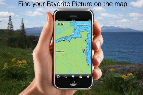
· Insert Unlimited Markers near favorite places on the map
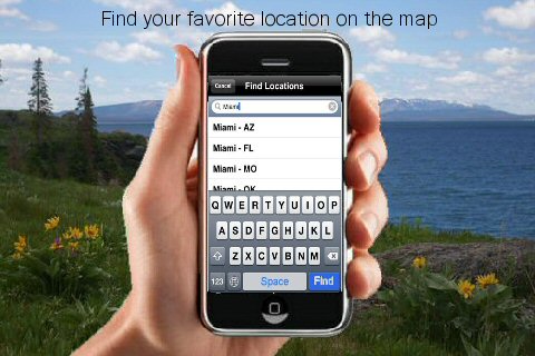
· Search your Favorite points directly
· Zoom, Rotate and Pan fast just by a finger touch
· Navigate and see your GPS position on the map
· Geo-Tagged photo management
· Set On/Off Elevation Contours if you feel data is cluttering
What's New in This Release:
· GPS Info Page
· Faster Names Search
Like it? Share with your friends!
If you got an error while installing Themes, Software or Games, please, read FAQ.
Supported operating systems:
Apple iOS 10.x (iPad), Apple iOS 10.x (iPhone), Apple iOS 11.x (iPad), Apple iOS 12.x (iPad), Apple iOS 12.x (iPhone), Apple iOS 4.0.x (iPhone), Apple iOS 4.0.x (iPod Touch), Apple iOS 4.2.x (iPad), Apple iOS 4.2.x (iPhone), Apple iOS 4.2.x (iPod Touch), Apple iOS 4.3.x (iPad), Apple iOS 4.3.x (iPhone), Apple iOS 4.3.x (iPod Touch), Apple iOS 5.0 (iPad), Apple iOS 5.0 (iPhone), Apple iOS 5.0 (iPod Touch), Apple iOS 6.0 (iPad), Apple iOS 6.0 (iPhone), Apple iOS 6.0 (iPod Touch), Apple iOS 7.0 (iPad), Apple iOS 7.0 (iPhone), Apple iOS 7.0 (iPod Touch), Apple iOS 8.x (iPad), Apple iOS 8.x (iPhone), Apple iOS 8.x (iPod Touch), Apple iOS 9.x (iPad), Apple iOS 9.x (iPhone), Apple iOS 9.x (iPod Touch)
Similar Software:
Green Mountain National Forest - GPS Map Navigator Green Mountain National Forest - GPS Map Navigator - Continues in the tradition of offering depth of information and functionality across expected places all over the world, exploring the map you get maximum details obtaining detailed information of each object on the map
Guide Map Orlando Guide Map Orlando - This app provides you with mobile access to detailed interactive Orlando maps, designed to help you enjoy the must-see attractions - the resorts, entertainment, studios, water parks, shopping, theatres, and more - that make up the Orlando experience.
· LOCATE ME: Find out where you are and display your location on the map with a blue pin
Bremen (Germany) Map Offline Bremen (Germany) Map Offline - This will be perfect when you are traveling and you don't have internet connection. This Offline Maps is not a replacement of Google Maps. It is used when you don't have internet connection and want to use maps
Manchester Map and Walking Tours Manchester Map and Walking Tours - This Lite version of the walking tours application comes with a detailed and fully functional city map to assist you explore the city and locate sights. City map functions in this app include: street name and business (restaurants, cafes, etc
Gothenburg Maps Offline Gothenburg Maps Offline - This will be perfect when you are traveling and you don't have internet connection. This Offline Maps is not a replacement of Google Maps. It is used when you don't have internet connection and want to use maps
Gran Cayman - GPS Map Navigator Gran Cayman - GPS Map Navigator - FlytoMap provides complete, quick and easy to use map applications for navigation for iPhone. Continues in the tradition of offering depth of information and functionality across expected places all over the world, exploring the map you get maximum details obtaining detailed information of every object on the map
San Antonio Map Offline San Antonio Map Offline - This will be perfect when you are traveling and you don't have internet connection. This Offline Maps is not a replacement of Google Maps. It is used when you don't have internet connection and want to use maps
Smart Maps - Edinburgh Smart Maps - Edinburgh - Smart Maps offers you an offline street level map, allowing you to search or navigate without an internet connection. Smart Maps will save you the money you pay for expensive data roaming charges or additional costs for local internet traffic.
· No internet connection required
New Orleans Map Offline New Orleans Map Offline - This will be perfect when you are traveling and you don't have internet connection. This Offline Maps is not a replacement of Google Maps. It is used when you don't have internet connection and want to use maps
North York Moors National Park - GPS Map Navigator North York Moors National Park - GPS Map Navigator - FlytoMap provides complete, quick and easy to use map applications for navigation for iPhone. Continues in the tradition of offering depth of information and functionality across expected places all over the world, exploring the map you get maximum details obtaining detailed information of every object on the map
Other Software by developer «Flytomap»:
Theodore Roosevelt National Park - GPS Map Navigator Theodore Roosevelt National Park - GPS Map Navigator - Continues in the tradition of offering depth of information and functionality across expected places all over the world, exploring the map you get maximum details obtaining detailed information of each object on the map
Cape Cod National Seashore - GPS Map Navigator Cape Cod National Seashore - GPS Map Navigator - Continues in the tradition of offering depth of information and functionality across expected places all over the world, exploring the map you get maximum details obtaining detailed information of each object on the map
Mille Lacs Lake - Fishing Mille Lacs Lake - Fishing - Mille Lacs Lake is Minnesota's second largest inland lake. Relatively shallow, the large lake is one of many glacial pothole lakes in the area 100 miles west of Duluth.
Mille Lacs Lake shines especially for fishing activities
Agate Fossil Beds National Monument - GPS Map Navigator Agate Fossil Beds National Monument - GPS Map Navigator - Continues in the tradition of offering depth of information and functionality across expected places all over the world, exploring the map you get maximum details obtaining detailed information of each object on the map
Allegheny National Forest & CA - (Lakes&Marine) Allegheny National Forest & CA - (Lakes&Marine) - Continues in the tradition of offering depth of information and functionality across expected places all over the world, exploring the map you get maximum details obtaining detailed information of each object on the map
Donana National Park - GPS Map Navigator Donana National Park - GPS Map Navigator - FlytoMap provides complete, quick and easy to use map applications for navigation for iPhone. Continues in the tradition of offering depth of information and functionality across expected places all over the world, exploring the map you get maximum details obtaining detailed information of every object on the map
Crater Lake National Park - GPS Map Navigator Crater Lake National Park - GPS Map Navigator - Continues in the tradition of offering depth of information and functionality across expected places all over the world, exploring the map you get maximum details obtaining detailed information of each object on the map
Marine: UK-Ireland-Netherlands - GPS Map Navigator Marine: UK-Ireland-Netherlands - GPS Map Navigator - The FlyToMap App resembles a Chart plotter on your mobile device, to the Great Waterways of UK-Ireland-Netherlands providing value added map features and information for sailing signifying all the nautical standards for safe navigation
Cabaneros National Park - GPS Map Navigator Cabaneros National Park - GPS Map Navigator - FlytoMap provides complete, quick and easy to use map applications for navigation for iPhone. Continues in the tradition of offering depth of information and functionality across expected places all over the world, exploring the map you get maximum details obtaining detailed information of every object on the map
Crater Lake National Park - Standard Crater Lake National Park - Standard - Continues in the tradition of offering depth of information and functionality across expected places all over the world, exploring the map you get maximum details obtaining detailed information of each object on the map
Comments on Parque Nacional Maritimo-Terrestre de Las Islas Atlanticas de Galicia - GPS Map Navigator:
Comments not found
If you noted an error or download link is broken, please, report it via this page or use comments.
Parque Nacional Maritimo-Terrestre de Las Islas Atlanticas de Galicia - GPS Map Navigator is compatible with your device Apple iPhone 11 Pro Max A2220 Dual SIM TD-LTE CN 512GB (Apple iPhone 12,5)

")


 Map Offline")


")


