Platforms: iPhone, iPad, iPod Touch, Apple iPhone OS
Categories: Travel & Navigation
Upload date: 10 Jul 13
Developer: Visual IT
License: Commercial
Price: 2.99 $
Downloads: 23
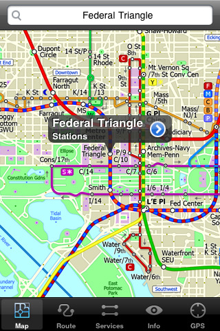
Washington Metro by Zuti - The new Washington Metro 10 map makes it easy to travel in and around the city using the WMATA Metro, MARC and VME systems. Also included are the Potomac river taxi routes and the DC Circulator bus routes. Unlike old fashioned schematic style maps this product contains a geographically accurate central area showing major streets, parks and places of interest etc, allowing the user to easily get their bearings.
MAP
The map is hand drawn by Visual IT and provides a unique geographically based view of Washington DC with many places of interest drawn directly on the background so you can easily get your bearings when traveling around the city. You can also use your inbuilt GPS to accurately locate and track yourself within the city centre and see the nearest transportation stop and distance to it. This is the only pubic transportation route planner with this ability.
Tap on the map for location information, use the inbuilt search feature or choose from a list of locations. Places of interest, museums, hotels, parks, restaurant, shops, hospitals, streets, etc, are also included. The route planner will automatically suggest the nearest station to any place of interest you select.
MINUTE MAP
Another great feature is the “Minute Map” option which allows you to see the travel times from a start point to all other locations on the map. This is a unique way to view the topology of a city and gauge traveling times.
ROUTING
The application does not require an internet connection and will always be available to display a clear and detailed view of the city transport systems, plus list and animate the optimum route for your journey. This product provides the fastest route calculations of any mobile routing application (virtually instantaneous) using actual published journey times with the ability to select the quickest route or the route with the least changes.
LIVE INFO
When an internet connection is available, optional "Live Information" on the current state of the transport services can be viewed (and automatically saved for future reference) allowing you to plan your journeys in advance and avoid any potential delays. Unique to this application is the ability to turn off services that are out of action and automatically calculate an alternative route.
· Full offline map and routing, no internet connection required.
· Colourful clear custom drawn geographically accurate mapping.
· Unique "Minute Map" feature allows quick view of all journey times from a start location.
· Services can be viewed on the map and turned on/off, routing around problems.
· Works on iPhone or iPod and in landscape or portrait mode.
· GPS location and tracking.
· Streets, Places of interest etc built into the application.
· Favourite routes can be stored and recalled.
· Access to live service information.
What's New in This Release:
· New map and routing.
· Improved "Travel Explorer" mode.
What's New in 1.3:
· Support for retina display
· New "Measure Tool"
· Bug fix for iOS 5
What's New in 1.2:
· Updated map and routes.
· Faster map loading.
· New route description text and layout.
· New "Take me home" option.
· New "Recent routes" option.
· Improved Live Info, now with departure boards.
· Various other minor updates and improvements.
Like it? Share with your friends!
If you got an error while installing Themes, Software or Games, please, read FAQ.
Supported operating systems:
Apple iOS 10.x (iPad), Apple iOS 10.x (iPhone), Apple iOS 11.x (iPad), Apple iOS 12.x (iPad), Apple iOS 12.x (iPhone), Apple iOS 4.0.x (iPhone), Apple iOS 4.0.x (iPod Touch), Apple iOS 4.2.x (iPad), Apple iOS 4.2.x (iPhone), Apple iOS 4.2.x (iPod Touch), Apple iOS 4.3.x (iPad), Apple iOS 4.3.x (iPhone), Apple iOS 4.3.x (iPod Touch), Apple iOS 5.0 (iPad), Apple iOS 5.0 (iPhone), Apple iOS 5.0 (iPod Touch), Apple iOS 6.0 (iPad), Apple iOS 6.0 (iPhone), Apple iOS 6.0 (iPod Touch), Apple iOS 7.0 (iPad), Apple iOS 7.0 (iPhone), Apple iOS 7.0 (iPod Touch), Apple iOS 8.x (iPad), Apple iOS 8.x (iPhone), Apple iOS 8.x (iPod Touch), Apple iOS 9.x (iPad), Apple iOS 9.x (iPhone), Apple iOS 9.x (iPod Touch), Apple iPhone OS 3.1.x, Apple iPhone OS 3.1.x (iPod Touch), Apple iPhone OS 3.2.x (iPad)
Similar Software:
Virginia Wine In My Pocket Virginia Wine In My Pocket - According to the Travel Channel, "Virginia is carving its own niche in the little black books of savvy wine lovers searching for the next big thing."
Virginia Wine in My Pocket is a guide for travelers in Virginia wine country
TransitGuru Portland TriMet The only transit app that offers offline schedules, system maps, multiple transportation types (train or bus) or agencies for single metro areas, alarms to wake you up when arrival, and integration with Yelp and Google Map
Las Vegas Maps Las Vegas Maps - software that helps you download and store the travel maps and plans you need. This super-handy app lets you download publicly available maps and store them on your iPhone or iPod Touch. You can download the maps when you have fast wifi connection - and then use any time in the future without delay
Trip Journal Free (iPhone) Trip Journal is the #1 Travel Application with the best trip tracking, recording, documenting and sharing features currently available for the iPhone.
Trip Journal allows you to document vacation experiences and share them with your friends and family
TransitM&S Orlando TransitM&S Orlando - TransitM&S is an easy-to-use transit application that provides bus info LYNX Transit at the metro Orlando area.
The app is designed for offline use. It is ideal for iPod Touch users. Even for iPhone users, it is designed to save money because AT&T no longer offers the unlimited data plan
Trip Planner Pro Trip Planner Pro - Trip Planner by GPSmyCity is a handy tool for planning your daily activities.
You can create daily itineraries for your trip, write down notes, track activities, and share your activity details with your friends. This application keeps all your travel details at your fingertips
North America - iGO primo Lite North America - iGO primo Lite - iGO primo Lite is a free route planner and map viewer built upon the experienced iGO Engine employed by GPS navigation devices all over the world. The software uses accurate offline maps which can be used anywhere. This way you don't have to worry about losing your internet connection, and you avoid unnecessary data traffic costs
StayHIP StayHIP is the best way to find and book boutique hotels. StayHIP brings you only the most chic and unique hotels in the world all with lush pictures, lists of amenities and the ability to search for your hotel by keywords. And you can book your room right in the application
Rome Metro 09 Rome Metro 09 - The “Rome Metro” application is a superb geographically based map and route planner for the Rome Metro, Tram, Urban and Regional rail systems. This application is one in a worldwide series of Zuti maps from Visual IT who have been producing public transportation maps for mobile devices for many years
Lancaster London (iPhone) Lancaster London (iPhone) - There's one thing that guests at Lancaster London always seem to agree on - the views are breathtaking. With Hyde Park, the largest of the Royal Parks, directly to the south, and vistas east to the City of London, we have arguably the best views in London
Other Software by developer «Visual IT»:
Tube Tyne & Wear (UIQ) Tube Tyne & Wear (UIQ) - An award winning and highly acclaimed application that guides you around the metro system of Tyne & Wear.
An essential addition to your Sony Ericsson P800 / P900 / P910 if you travel in or around this city
· A detailed clear colour map of the Tyne & Wear metro system fully scrollable.
· Quick find station utility
Berlin Metro for iPad by Zuti Berlin Metro for iPad by Zuti - This Berlin Metro map makes it easy to travel in and around the city using the Metro (U-Bahn) Suburban Rail (S-Bahn) and Tram (MetroTram and Straßenbahn) systems
Paris Metro for iPad by Zuti Paris Metro 10 - This Zuti application contains a visually unique map of the Paris transport system and a superb animated journey planner to help you get around the Metro, RER, SNCF, Tram, Tvm, and Vogueo services. Now revised and updated to include a larger geographic area which covers more of the outlying areas surrounding Paris
Madrid Metro for iPad by Zuti Madrid Metro for iPad by Zuti - Madrid Metro map makes it easy to travel in and around the city using the the Metro, Renfe Rail and Metro Ligero Rail services. Unlike old fashioned schematic style maps this product contains a geographically accurate central area showing major streets, parks and places of interest etc, allowing the user to easily get their bearings
Great Britain Rail for iPad by Zuti Great Britain Rail for iPad by Zuti - The new Great Britain Rail map makes it easy to travel in and around the country using the rail services. This application contains a geographically accurate map of the whole of Great Britain allowing you to easily view the route of any journey
Vienna Metro by Zuti Vienna Metro by Zuti - This Zuti application contains a visually unique map of Vienna's transport systems and a superb animated journey planner to help you get around the Metro (U-Bahn), Suburban Rail (S-Bahn) and Tram (Stragenbahn)
Digital Camera Guide (Palm OS) Digital Camera Guide (Palm OS) - An essential guide for anyone new to the world of digital photography. In a simple easy to read format with superb photographs it helps you to get the most from your camera and explains how many of the complicated features of your camera work.
Index of subjects covered:
- Camera Controls
Tube 2 New York City Pro (Palm OS) Tube 2 New York City Pro (Palm OS) - This map package for Tube 2 consists of a fully scrollable detailed map of the New York City MTA subway system and linked high quality street maps of Manhattan. Also included are additional reference maps of the rail systems surrounding NYC
Tube Toronto (UIQ) Tube Toronto (UIQ) - Our award winning and highly acclaimed application guides you around the subway system of Toronto is now available for your Symbian UIQ phone.
An essential addition to your P800 / P900 / P910 if you travel in or around this city
· A detailed clear colour map of the Toronto subway system fully scrollable.
· Quick find station utility
Tube 2 Amsterdam Pro (UIQ3) Tube 2 Amsterdam Pro (UIQ3) - This map package for Tube 2 consists of a fully scrollable detailed map of the Amsterdam tram & metro system and linked street maps of central Amsterdam.
Plan journeys on the tram & metro system, list details of the quickest routes and see a superb animated display of your journey tracking around the system map

")


")


")
")


")
")
")
")