Free Apple iPhone 11 Pro Max A2218 Global Dual SIM TD-LTE 512GB (Apple iPhone 12,5) GPS Guide Vokrug Sveta Software Download in Travel & Navigation Tag
Platforms: iPhone, iPad, iPod Touch, Apple iPhone OS
Categories: Travel & Navigation
Upload date: 19 Oct 11
Developer: VITO Technology
License: Freeware
Downloads: 87
GPS Guide Vokrug Sveta - VOKRUG SVETA GPS-guide, created by VOKRUG SVETA publishing house, is a one-of-a-kind application for the independent traveler. This application allows owners of portable devices with GPS receivers to create exciting and intellectually stimulating itineraries on their very own.
The GPS-guide consists of the VS Guide navigation program and multimedia itineraries.
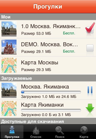
The application consists of two parts: the free-of-charge downloadable Client and the Add-on modules containing comprehensive information about each of a city’s noteworthy neighborhoods or districts. These Add-on modules we call “itineraries”.
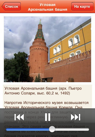
The itineraries are downloaded through the application. Each one includes an audio-guide along with photos of select “places of interest” and their descriptions. When the download of the desired itinerary is complete, a map of the area becomes available.
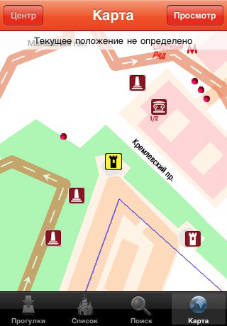
Having loaded the appropriate itinerary, you can set out on a walk as you listen to the virtual guide – your headphones on and the device in your pocket. The application pinpoints your location and draws your attention to all visible “places of interest.” There are no fixed routes. The VS guide adapts automatically to any direction.
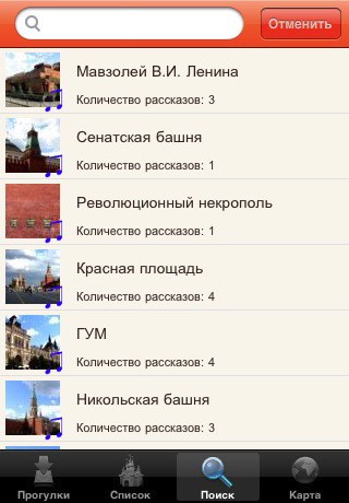
The application allows you to look at photos of the nearest "place of interest," read the accompanying descriptions, and locate yourself on the map. "Places of interest" are sorted in a list according to their distance from your location. It is also possible to view them on the map.
The VS guide also has a special “virtual walk” mode for those who like to prepare ahead of time or for those who do not have GPS-receivers. This mode allows you to listen to the audio-guide, look at the pictures, and enjoy all the benefits of travel without ever leaving your home.
Like it? Share with your friends!
If you got an error while installing Themes, Software or Games, please, read FAQ.
Supported operating systems:
Apple iOS 10.x (iPad), Apple iOS 10.x (iPhone), Apple iOS 11.x (iPad), Apple iOS 12.x (iPad), Apple iOS 12.x (iPhone), Apple iOS 4.0.x (iPhone), Apple iOS 4.0.x (iPod Touch), Apple iOS 4.2.x (iPad), Apple iOS 4.2.x (iPhone), Apple iOS 4.2.x (iPod Touch), Apple iOS 4.3.x (iPad), Apple iOS 4.3.x (iPhone), Apple iOS 4.3.x (iPod Touch), Apple iOS 5.0 (iPad), Apple iOS 5.0 (iPhone), Apple iOS 5.0 (iPod Touch), Apple iOS 6.0 (iPad), Apple iOS 6.0 (iPhone), Apple iOS 6.0 (iPod Touch), Apple iOS 7.0 (iPad), Apple iOS 7.0 (iPhone), Apple iOS 7.0 (iPod Touch), Apple iOS 8.x (iPad), Apple iOS 8.x (iPhone), Apple iOS 8.x (iPod Touch), Apple iOS 9.x (iPad), Apple iOS 9.x (iPhone), Apple iOS 9.x (iPod Touch), Apple iPhone OS 3.1.x, Apple iPhone OS 3.1.x (iPod Touch), Apple iPhone OS 3.2.x (iPad)
Similar Software:
Bordeaux & Arcachon Travel Guide Bordeaux & Arcachon Travel Guide - Stop carrying heavy city tours guide in your pocket. TRAVEL LIGHT!!!
With Etips City Travel Guides you have a full city guide in your iPhone or iPod touch.
This tourist guide is built to be used offline
George Town Walking Tours and Map This application presents you several self-guided walking tours to see the best of the city, and it comes with detailed tour route maps and powerful navigation features to guide you from one sight to the next
Fotopedia National Parks Fotopedia National Parks - An extraordinary collection of 3,000 stunning photos by renowned professional photographer Quang-Tuan Luong.
Discover first the diversity of the National Parks through a selected set of 1,500 photos at the top, then dive in specific parks to find even more photos
Brisbane Map and Walking Tours Brisbane Map and Walking Tours - This Lite version of the walking tours application comes with a detailed and fully functional city map to assist you explore the city and locate sights. City map functions in this app include: street name and business (restaurants, cafes, etc
Melbourne Travel Guide - Lonely Planet Comprehensive maps ensure you're never lost in this vast cultural playground; detailed history, culture and language chapters give you an essential entree to local life and independent, in-depth research means you'll never need to second guess
San Francisco City Travel Guide With Etips City Travel Guides you have a full city guide in your iPhone or iPod touch. This tourist guide is built to be used offline. No connection to Internet required, meaning no extra charges in your phone bill!
Iceland Travel Guide by Triposo for iPhone/iPad Iceland Travel Guide by Triposo for iPhone/iPad - Iceland Travel Guide by Triposo is a free interactive travel guide to Iceland. It includes an offline map which allows you to easily find places to visit, shops, restaurants and other points of interest
Sanibel-Captiva Islands Essential Guide Sanibel-Captiva Islands Essential Guide - Sanibel Island, Florida: It conjures images of seashell-carpeted beaches, lazy gulf waves, skies and beaches full of birds, and palm-tree-silhouetted skies. Readers of Conde Nast Traveler name it among the top 10 U.S. islands year after year. Birding and paddling magazines, too, sing its praises
myCanada for iPhone myCanada for iPhone - Show your pride in your heritage, homeland or favorite place to visit.
· Share messages and photos with other users. You will also see comments/photos posted by other users.
· Tag a map of your country with your favorite places and recommendations for others
Other Software by developer «VITO Technology»:
Map of Pennsylvania (US State) Map of Pennsylvania (US State) - A map of the Pennsylvania by VITO Technology. Good for intercity travels with SmartMap.
SmartMap is a mobile device application which uses vector and raster maps. It is compatible with any NMEA protocol GPS receiver (Compact Flash socket, serial port, BlueTooth or sleeve)
VITO ActiveTrace VITO ActiveTrace is a sports oriented software specially designed to help you watch your sports progress. VITO ActiveTrace turns a Smartphone into your personal coach that accurately keeps detailed statistics for every trip and also records corresponding tracks. Just turn VITO ActiveTrace on, put your device in a pocket and concentrate on training
Map of Vietnam Map of Vietnam - A map of Vietnam.
Good for intercity travels with SmartMap.
Layers include:
Towns
Settlements
Airports
Roads
Railroads
Rivers
Inland water
Administrative borders
International borders
Trees
Map scale is 1:1 million
Map of Western Sahara Map of Western Sahara - A map of Western Sahara. Good for intercity travels with SmartMap.
Layers include:
Towns
Settlements
Airports
Roads
Railroads
Rivers
Inland water
Administrative borders
International borders
Trees
Map scale is 1:1 million.
Good for use with any version of SmartMap
Map of Sweden Map of Sweden - Set of 2 maps of Sweden accompanied by a short text description.
SWEDEN (NORTH)
SWEDEN (SOUTH)
Good for intercity travels with SmartMap
Gyrocompass 3D Free Gyrocompass 3D Free - Augmented reality comes to the new iPod Touches! Tap the Gyrocompass 3D application on your iPhone 4 or 4th generation iPod Touch to turn it into a fully functioning three-dimensional compass
Map of South Korea Map of South Korea -
A map of South Korea. Good for intercity travels with SmartMap.
Layers include:
Towns
Settlements
Airports
Roads
Railroads
Rivers
Inland water
Administrative borders
International borders
Trees
Map scale is 1:1 million.
Good for use with any version of SmartMap
Solar Walk - Saturn Solar Walk - Saturn - This app is a lite version of the popular astronomy software Solar Walk. It lets you explore Saturn, the sixth planet from the Sun, as well as its moons: Mimas, Enceladus, Tethys, Dione, Rhea, Titan, Hyperion, and Iapetus, in 3D
VITO AudioPlayer VITO AudioPlayer-This easy-to-use application runs swiftly and has the basic playback features.
Full MP3, Ogg, WAV support
Map of North Carolina (US State) Map of North Carolina (US State) - A map of the North Carolina by VITO Technology. Good for intercity travels with SmartMap.
SmartMap is a mobile device application which uses vector and raster maps. It is compatible with any NMEA protocol GPS receiver (Compact Flash socket, serial port, BlueTooth or sleeve)

")


 Travel Guides")


")


")