Platforms: iPhone, iPad, iPod Touch, Apple iPhone OS
Categories: Travel & Navigation
Upload date: 5 Sep 11
Developer: Flytomap
License: Commercial
Price: 9.99 $
Downloads: 25
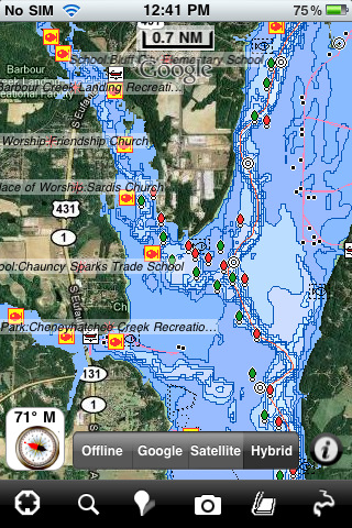
Lake Eufaula - Fishing - Lake Eufaula is the largest lake located in the state of Oklahoma. Offers a variety of recreational opportunities for everyone and is a fabulous tourist attraction. The shoreline ranges from vast area of sandy beaches to rocky bluffs.
FlyToMap offers high quality lake map with detailed information and important features compressed to assure the larger coverage. Lake Map contains most important DNR lakes with detailed ‘Depth Contours, Boat Ramps, Fishing spots etc.
· Advanced GPS Function
· Nav. Compass
· Gps Function
· Record & Email Tracks
· Localization support of 4 Languages
· Advanced Searching
· Insert Limitless Favorites
· Find Places by Lat/Lon
· High Quality Offline Overlay
What's New in This Release:
· GPS Info Page
· Faster Names Search
Like it? Share with your friends!
If you got an error while installing Themes, Software or Games, please, read FAQ.
Supported operating systems:
Apple iOS 10.x (iPad), Apple iOS 10.x (iPhone), Apple iOS 11.x (iPad), Apple iOS 12.x (iPad), Apple iOS 12.x (iPhone), Apple iOS 4.0.x (iPhone), Apple iOS 4.0.x (iPod Touch), Apple iOS 4.2.x (iPad), Apple iOS 4.2.x (iPhone), Apple iOS 4.2.x (iPod Touch), Apple iOS 4.3.x (iPad), Apple iOS 4.3.x (iPhone), Apple iOS 4.3.x (iPod Touch), Apple iOS 5.0 (iPad), Apple iOS 5.0 (iPhone), Apple iOS 5.0 (iPod Touch), Apple iOS 6.0 (iPad), Apple iOS 6.0 (iPhone), Apple iOS 6.0 (iPod Touch), Apple iOS 7.0 (iPad), Apple iOS 7.0 (iPhone), Apple iOS 7.0 (iPod Touch), Apple iOS 8.x (iPad), Apple iOS 8.x (iPhone), Apple iOS 8.x (iPod Touch), Apple iOS 9.x (iPad), Apple iOS 9.x (iPhone), Apple iOS 9.x (iPod Touch)
Similar Software:
Boston Map and Walking Tours Boston Map and Walking Tours - No need to hop on a tour bus or join a group; now you can explore all the best attractions on your own, at your own pace, and at a cost that is only a fraction of what you would normally pay for a guided tour
Smart Maps - Liverpool Smart Maps - Liverpool - Smart Maps offers you an offline street level map, allowing you to search or navigate without an internet connection. Smart Maps will save you the money you pay for expensive data roaming charges or additional costs for local internet traffic.
· No internet connection required
Trip Journal (iPhone) Trip Journal is the Google Awarded Travel Application with the best trip tracking, recording, documenting and sharing features currently available for iPhone.
Trip Journal allows you to document vacation experiences and share them with your friends and family
Fort Wayne (Indiana) Maps Offline Fort Wayne (Indiana) Maps Offline - This will be perfect when you are traveling and you don't have internet connection. This Offline Maps is not a replacement of Google Maps. It is used when you don't have internet connection and want to use maps
Tulsa Map Offline Tulsa Map Offline - This will be perfect when you are traveling and you don't have internet connection. This Offline Maps is not a replacement of Google Maps. It is used when you don't have internet connection and want to use maps
Bakersfield (CA, USA) Map Offline Bakersfield (CA, USA) Map Offline - This will be perfect when you are traveling and you don't have internet connection. This Offline Maps is not a replacement of Google Maps. It is used when you don't have internet connection and want to use maps
Odense Street Map Odense Street Map - Lets you find all streets, and many useful locations such as ATM's, parkings, museums, and many others. Remembers where you've been so you can find that parking spot where you left your rental car
Antwerpen Street Map Lite Antwerpen Street Map Lite - Lets you find all streets, and many useful locations such as ATM's, parkings, museums, and many others. Remembers where you've been so you can find that parking spot where you left your rental car
Virgin Islands - GPS Map Navigator Virgin Islands - GPS Map Navigator - FlytoMap provides complete, quick and easy to use map applications for navigation for iPhone. Continues in the tradition of offering depth of information and functionality across expected places all over the world, exploring the map you get maximum details obtaining detailed information of every object on the map
Cork Walking Tours and Map Cork Walking Tours and Map - No need to hop on a tour bus or join a group; now you can explore all the best attractions on your own, at your own pace, and at a cost that is only a fraction of what you would normally pay for a guided tour
Other Software by developer «Flytomap»:
Chippewa National Forest - Topo Chippewa National Forest - Topo - Continues in the tradition of offering depth of information and functionality across expected places all over the world, exploring the map you get maximum details obtaining detailed information of each object on the map
Channel Islands National Park - GPS Map Navigator Channel Islands National Park - GPS Map Navigator - Continues in the tradition of offering depth of information and functionality across expected places all over the world, exploring the map you get maximum details obtaining detailed information of each object on the map
Sequoia - Kings National Park - GPS Map Navigator Sequoia - Kings National Park - GPS Map Navigator - Continues in the tradition of offering depth of information and functionality across expected places all over the world, exploring the map you get maximum details obtaining detailed information of each object on the map
Mammoth Cave National Park - GPS Map Navigator Mammoth Cave National Park - GPS Map Navigator - Continues in the tradition of offering depth of information and functionality across expected places all over the world, exploring the map you get maximum details obtaining detailed information of each object on the map
Lakes: Texas Lakes: Texas - Continues in the tradition of offering depth of information and functionality across expected places all over the world, exploring the map you get maximum details obtaining detailed information of each object on the map
Marine: Oslo Fjord HD - GPS Map Navigator Marine: Oslo Fjord HD - GPS Map Navigator - FlytoMap provides complete, quick and easy to use map applications for navigation for iPad. Continues in the tradition of offering depth of information and functionality across expected places all over the world, exploring the map you get maximum details obtaining detailed information of every object on the map
Zanzibar - GPS Map Navigator Zanzibar - GPS Map Navigator - FlytoMap provides complete, quick and easy to use map applications for navigation for iPhone. Continues in the tradition of offering depth of information and functionality across expected places all over the world, exploring the map you get maximum details obtaining detailed information of every object on the map
Gaudalupe HD - GPS Map Navigator Gaudalupe HD - GPS Map Navigator - FlytoMap provides complete, quick and easy to use map applications for navigation. Continues in the tradition of offering depth of information and functionality across expected places all over the world, exploring the map you get maximum details obtaining detailed information of every object on the map
Green Mountain National Forest - Standard Green Mountain National Forest - Standard - Continues in the tradition of offering depth of information and functionality across expected places all over the world, exploring the map you get maximum details obtaining detailed information of each object on the map

")


")
 Maps Offline")

 Map Offline")


