Buy Apple iPhone 11 Pro Max A2218 Global Dual SIM TD-LTE 512GB (Apple iPhone 12,5) Appennino Tosco-Emiliano National Park - GPS Map Navigator Application
Appennino Tosco-Emiliano National Park - GPS Map Navigator
Version: 3.3updated
Platforms: iPhone, iPad, iPod Touch, Apple iPhone OS
Categories: Travel & Navigation
Upload date: 18 Jan 12
Developer: Flytomap
License: Commercial
Price: 2.99 $
Downloads: 21
Appennino Tosco-Emiliano National Park - GPS Map Navigator - FlytoMap provides complete, quick and easy to use map applications for navigation for iPhone. Continues in the tradition of offering depth of information and functionality across expected places all over the world, exploring the map you get maximum details obtaining detailed information of every object on the map.
FlytoMap processes different types of maps for navigation for different categories:
WATER MAPS (Marine):
Water map navigator is the new ‘Marine Navigator for iPhone’ contains embedded Electronic Nautical Charts (ENC) from NOAA compressed to a large coverage. You can now download the application and transform your iPhone in a chart plotter with best NOAA, ENC S57 cartography; which includes Anchoring areas, Fishing areas, restriction areas, obstructions, rocks, Buoys, Beacons, Lights, Depth contours with Values display on map, Spot Soundings and more. The only marine app available in the market with such huge information. Every effort is made to be as accurate as possible when presenting information for every destination.
PARK MAPS:
Park map applications are extremely advanced contains embedded electronic charts with all information collected from the National Park Service and local sources. The maps contain all multiple trails (Hiking, biking, Stairway trails, Bicycle trails, Equestrian trails etc.,) and Point of interests (POI) like Campgrounds, Eating places, Ranger Stations, Picnic areas, Boat/Canoe launching, Parking areas etc., which are provided depending on the relevant park areas they exist.
LAKE MAPS:
We offer high quality lake maps with detailed information and important features compressed to assure the larger coverage in USA region. Lake maps contain most important DNR lakes with detailed ‘Depth Contours, Boat Ramps, Fishing spots etc. Also includes Trails, Roads and Railways information.
TRAVEL MAPS:
These Maps treat you mostly with information of both Marine and terrain correspondingly. These are the most preferable Maps to travel especially for fascinating recreational voyages, map focus the best Beach spots along the Coast line, Major ports, Sailing, Fishing, Picnic areas, Parks, Hiking, Biking, Clubs, restaurants, Famous Hotels, Museums, Shopping areas, and much more.
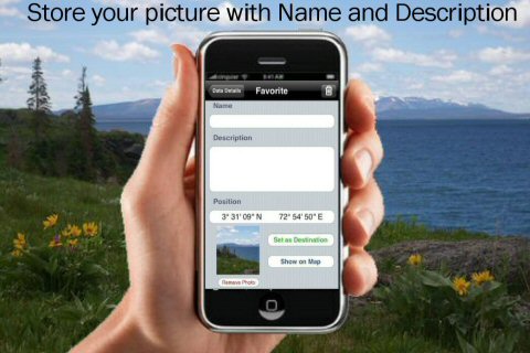
· Use Latitudes and Longitudes to go to your favorite places
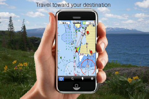
· Insert the target/destination 'Waypoint' and see in real time your speed, distance and direction to destination
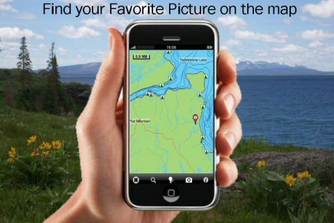
· Insert Unlimited Markers near favorite places on the map
· Search your Favorite points directly
· Zoom, Rotate and Pan fast just by a finger touch
· Navigate and see your GPS position on the map
· Geo-Tagged photo management
· Set On/Off Elevation Contours if you feel data is cluttering
What's New in This Release:
· Fixed bug on Favorites and Camera management
What's New in 3.1:
· GPS Info Page
· Faster Names Search
Like it? Share with your friends!
If you got an error while installing Themes, Software or Games, please, read FAQ.
Supported operating systems:
Apple iOS 10.x (iPad), Apple iOS 10.x (iPhone), Apple iOS 11.x (iPad), Apple iOS 12.x (iPad), Apple iOS 12.x (iPhone), Apple iOS 4.0.x (iPhone), Apple iOS 4.0.x (iPod Touch), Apple iOS 4.2.x (iPad), Apple iOS 4.2.x (iPhone), Apple iOS 4.2.x (iPod Touch), Apple iOS 4.3.x (iPad), Apple iOS 4.3.x (iPhone), Apple iOS 4.3.x (iPod Touch), Apple iOS 5.0 (iPad), Apple iOS 5.0 (iPhone), Apple iOS 5.0 (iPod Touch), Apple iOS 6.0 (iPad), Apple iOS 6.0 (iPhone), Apple iOS 6.0 (iPod Touch), Apple iOS 7.0 (iPad), Apple iOS 7.0 (iPhone), Apple iOS 7.0 (iPod Touch), Apple iOS 8.x (iPad), Apple iOS 8.x (iPhone), Apple iOS 8.x (iPod Touch), Apple iOS 9.x (iPad), Apple iOS 9.x (iPhone), Apple iOS 9.x (iPod Touch)
Similar Software:
Malmo Map Offline Malmo Map Offline - This will be perfect when you are traveling and you don't have internet connection. This Offline Maps is not a replacement of Google Maps. It is used when you don't have internet connection and want to use maps
Navitel Navigator for iPhone/iPad Navitel Navigator for iPhone/iPad - Navitel Navigator is a GPS travel assistant for iPhone, iPad and iPod touch. The app turns your mobile device into a personal navigation system
TomTom Australia TomTom Australia - Get the TomTom navigation app and have smart, easy-to-use, turn-by-turn navigation on your iPhone or iPod touch, whenever and wherever you need it.
And, now, never miss a turn. The new TomTom app guides you even while you are on a call or running a different app on your iPhone
Spokane - Veradale (Washington) Map Offline Spokane - Veradale (Washington) Map Offline - This will be perfect when you are traveling and you don't have internet connection. This Offline Maps is not a replacement of Google Maps. It is used when you don't have internet connection and want to use maps
Nationalpark Bayerischer Wald - GPS Map Navigator Nationalpark Bayerischer Wald - GPS Map Navigator - FlytoMap provides complete, quick and easy to use map applications for navigation for iPhone. Continues in the tradition of offering depth of information and functionality across expected places all over the world, exploring the map you get maximum details obtaining detailed information of every object on the map
NAVIGON U.S. East With NAVIGON MyRegion you can transform your iPhone into a fully functional mobile navigation system that is every bit as good as the multi-award-winning personal navigation devices from NAVIGON in terms of its user-friendliness and features
EEU Region - iGO primo app EEU Region - iGO primo app - iGO primo app turns your iOS device into a powerful navigation system. Using the same experienced iGO Engine employed by GPS navigation devices all over the world, the app can reliably guide you to your destination in no time.
The software uses accurate offline maps which can be used anywhere
Sygic Pakistan: GPS Navigation Sygic Pakistan: GPS Navigation - Sygic is a premium turn-by-turn GPS navigation application. Sygic boasts an intuitive interface: drag the map, pinch to zoom, change point of view using built-in compass and tap target square to choose action
Augsburg (Germany) Map Offline Augsburg (Germany) Map Offline - This will be perfect when you are traveling and you don't have internet connection. This Offline Maps is not a replacement of Google Maps. It is used when you don't have internet connection and want to use maps
Riverside - Moreno Valley - San Bernardino Maps Offline Riverside - Moreno Valley - San Bernardino Maps Offline - This will be perfect when you are traveling and you don't have internet connection. This Offline Maps is not a replacement of Google Maps. It is used when you don't have internet connection and want to use maps
Other Software by developer «Flytomap»:
Marine: Mediterranean Sea HD - GPS Map Navigator Marine: Mediterranean Sea HD - GPS Map Navigator - FlytoMap provides complete, quick and easy to use map applications for navigation for iPad. Continues in the tradition of offering depth of information and functionality across expected places all over the world, exploring the map you get maximum details obtaining detailed information of every object on the map
Big Cypress National Preserve - GPS Map Navigator Big Cypress National Preserve - GPS Map Navigator - Continues in the tradition of offering depth of information and functionality across expected places all over the world, exploring the map you get maximum details obtaining detailed information of each object on the map
Duvenstedter Brook Nature Reserve - GPS Map Navigator Duvenstedter Brook Nature Reserve - GPS Map Navigator - The Duvenstedter Brook Nature Reserve is a vast spread of woodland, heath land, meadows and marshy areas Located in Hamburg's northerly suburbs, this is a true wildlife haven and full of indigenous animals and plants
Apostle Islands National Lakeshore - GPS Map Navigator Apostle Islands National Lakeshore - GPS Map Navigator - Continues in the tradition of offering depth of information and functionality across expected places all over the world, exploring the map you get maximum details obtaining detailed information of each object on the map
Marine: Miami to Key West - GPS Map Navigator Marine: Miami to Key West - GPS Map Navigator - Continues in the tradition of offering depth of information and functionality across expected places all over the world, exploring the map you get maximum details obtaining detailed information of each object on the map
Samoa - GPS Map Navigator Samoa - GPS Map Navigator - FlytoMap provides complete, quick and easy to use map applications for navigation. Continues in the tradition of offering depth of information and functionality across expected places all over the world, exploring the map you get maximum details obtaining detailed information of every object on the map
Grand Teton National Park - GPS Map Navigator Grand Teton National Park - GPS Map Navigator - Continues in the tradition of offering depth of information and functionality across expected places all over the world, exploring the map you get maximum details obtaining detailed information of each object on the map
Kellerwald-Edersee National Park - GPS Map Navigator Kellerwald-Edersee National Park - GPS Map Navigator - FlytoMap provides complete, quick and easy to use map applications for navigation for iPhone. Continues in the tradition of offering depth of information and functionality across expected places all over the world, exploring the map you get maximum details obtaining detailed information of every object on the map
Lake Francis Case - Fishing Lake Francis Case - Fishing - Continues in the tradition of offering depth of information and functionality across expected places all over the world, exploring the map you get maximum details obtaining detailed information of each object on the map
Marine: Melbourne HD - GPS Map Navigator Marine: Melbourne HD - GPS Map Navigator - FlytoMap provides complete, quick and easy to use map applications for navigation for iPad. Continues in the tradition of offering depth of information and functionality across expected places all over the world, exploring the map you get maximum details obtaining detailed information of every object on the map
Comments on Appennino Tosco-Emiliano National Park - GPS Map Navigator:
Comments not found
If you noted an error or download link is broken, please, report it via this page or use comments.
Appennino Tosco-Emiliano National Park - GPS Map Navigator is compatible with your device Apple iPhone 11 Pro Max A2218 Global Dual SIM TD-LTE 512GB (Apple iPhone 12,5)

")


 Map Offline")


 Map Offline")


