Platforms: iPhone, iPad, iPod Touch, Apple iPhone OS
Categories: Travel & Navigation
Upload date: 19 Oct 11
Developer: VITO Technology
License: Freeware
Downloads: 87
GPS Guide Vokrug Sveta - VOKRUG SVETA GPS-guide, created by VOKRUG SVETA publishing house, is a one-of-a-kind application for the independent traveler. This application allows owners of portable devices with GPS receivers to create exciting and intellectually stimulating itineraries on their very own.
The GPS-guide consists of the VS Guide navigation program and multimedia itineraries.
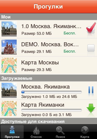
The application consists of two parts: the free-of-charge downloadable Client and the Add-on modules containing comprehensive information about each of a city’s noteworthy neighborhoods or districts. These Add-on modules we call “itineraries”.
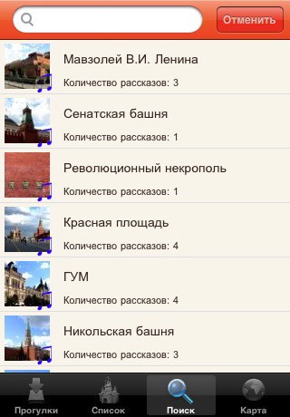
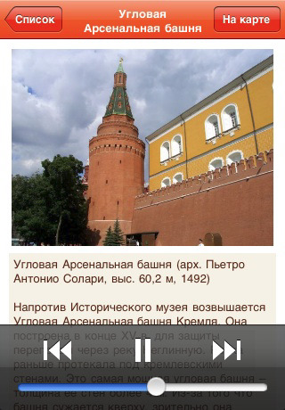
The itineraries are downloaded through the application. Each one includes an audio-guide along with photos of select “places of interest” and their descriptions. When the download of the desired itinerary is complete, a map of the area becomes available.
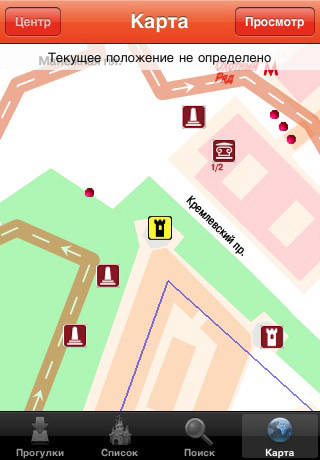
Having loaded the appropriate itinerary, you can set out on a walk as you listen to the virtual guide – your headphones on and the device in your pocket. The application pinpoints your location and draws your attention to all visible “places of interest.” There are no fixed routes. The VS guide adapts automatically to any direction.
The application allows you to look at photos of the nearest "place of interest," read the accompanying descriptions, and locate yourself on the map. "Places of interest" are sorted in a list according to their distance from your location. It is also possible to view them on the map.
The VS guide also has a special “virtual walk” mode for those who like to prepare ahead of time or for those who do not have GPS-receivers. This mode allows you to listen to the audio-guide, look at the pictures, and enjoy all the benefits of travel without ever leaving your home.
Like it? Share with your friends!
If you got an error while installing Themes, Software or Games, please, read FAQ.
Supported operating systems:
Apple iOS 10.x (iPad), Apple iOS 10.x (iPhone), Apple iOS 11.x (iPad), Apple iOS 12.x (iPad), Apple iOS 12.x (iPhone), Apple iOS 4.0.x (iPhone), Apple iOS 4.0.x (iPod Touch), Apple iOS 4.2.x (iPad), Apple iOS 4.2.x (iPhone), Apple iOS 4.2.x (iPod Touch), Apple iOS 4.3.x (iPad), Apple iOS 4.3.x (iPhone), Apple iOS 4.3.x (iPod Touch), Apple iOS 5.0 (iPad), Apple iOS 5.0 (iPhone), Apple iOS 5.0 (iPod Touch), Apple iOS 6.0 (iPad), Apple iOS 6.0 (iPhone), Apple iOS 6.0 (iPod Touch), Apple iOS 7.0 (iPad), Apple iOS 7.0 (iPhone), Apple iOS 7.0 (iPod Touch), Apple iOS 8.x (iPad), Apple iOS 8.x (iPhone), Apple iOS 8.x (iPod Touch), Apple iOS 9.x (iPad), Apple iOS 9.x (iPhone), Apple iOS 9.x (iPod Touch), Apple iPhone OS 3.1.x, Apple iPhone OS 3.1.x (iPod Touch), Apple iPhone OS 3.2.x (iPad)
Similar Software:
Singapore: Travel Guide Singapore: Travel Guide - It is a very practical city guide since it is designed to be used by itineraries. There are 4 different itineraries for the city depending on the duration of your journey. We also provide tips and advices to travelers, how to get into the city, how to move around, where to shop, where to go at night, most popular places, safety tips, etc..
Vancouver Map and Walking Tours Vancouver Map and Walking Tours - No need to hop on a tour bus or join a group; now you can explore all the best attractions on your own, at your own pace, and at a cost that is only a fraction of what you would normally pay for a guided tour
China Travel Guides China Travel Guides - It provides travel guides such as: General info, Districts, Getting there, Transport, Sights, Entertainment, Shopping, Eat, Drink, Place to stay, Contact, Stay safe
Sydney Photo Travel Guide Sydney Photo Travel Guide - Sydney is, without doubt, one of the most beautiful and photogenic cities on the planet. Think ‘Sydney’ and almost by default the mind explodes with imagery; from its glittering harbour and its surf beaches, to the Harbour Bridge and of course, the definitive sails of the Opera House
ProGuides - Dubai ProGuides - Dubai - Signs change, culture changes, and familiar streets are exchanged for more exotic ones. The challenge is how to see it all. How to take it all in without wasting your time, your energy or your budget. The answer is ProGuides.
· Great Introductions help you understand the local culture and history
Clarksville Travel Guides Offline travel guide with super fast loading page. No internet connection needed
Cannes: Travel Guide Cannes: Travel Guide - Stop carrying heavy city tours guide in your pocket. TRAVEL LIGHT!!!
With Etips City Travel Guides you have a full city guide in your iPhone, iPod Touch or iPad.
This tourist guide is built to be used offline
Thessaloniki Walking Tours and Map This application presents you several self-guided walking tours to see the best of the city, and it comes with detailed tour route maps and powerful navigation features to guide you from one sight to the next
Nottingham & Liverpool Travel Guide Nottingham & Liverpool Travel Guide - Stop carrying heavy city tours guide in your pocket. TRAVEL LIGHT!!!
With Etips City Travel Guides you have a full city guide in your iPhone, iPod Touch or iPad.
This tourist guide is built to be used offline
Istanbul Travel Guide by Triposo Istanbul Travel Guide by Triposo - Free interactive travel guide to Istanbul. Works offline and has a detailed map.
About our guide
We make great, interactive travel guides.
To make our guides we use the content that is freely available. Open content sites like Wikitravel, Wikipedia, World66 and Openstreetmap are among the best resources for any traveler
Other Software by developer «VITO Technology»:
Map of Wyoming (US State) Map of Wyoming (US State) - A map of the Wyoming by VITO Technology. Good for intercity travels with SmartMap.
SmartMap is a mobile device application which uses vector and raster maps. It is compatible with any NMEA protocol GPS receiver (Compact Flash socket, serial port, BlueTooth or sleeve)
Map of Slovakia Map of Slovakia - A map of Slovakia, divided into 4 smaller territories for the ease of use.
BRATISLAVA
ZAPADOSLOVENSKY
STREDOSLOVENSKY
VYCHODOSLOVENSKY
Good for intercity travels with SmartMap
Map of Serbia Map of Serbia - A map of Serbia good for intercity travels with SmartMap.
Layers include:
Towns
Settlements
Airports
Roads
Railroads
Rivers
Inland water
Administrative borders
International borders
Trees
Map scale is 1:1 million.
Good for use with any version of SmartMap. SmartMap can be purchased here
Map of Sudan Map of Sudan - A map of Sudan, divided into 9 smaller territories for the ease of use.
ASH SHARQIYAH
ASH SHAMALIYAH
DARFUR
AL KHARTUM
KURDUFAN
AL WUSTA
A'ALI AN NIL
BAHR AL GHAZAL
AL ISTIWA'IYAH
Good for intercity travels with SmartMap
Map of Singapore Map of Singapore -
A map of Singapore. Good for travels with SmartMap.
Layers include:
Towns
Settlements
Airports
Roads
Railroads
Rivers
Inland water
Administrative borders
International borders
Trees
Map scale is 1:1 million.
Good for use with any version of SmartMap. SmartMap can be purchased here
Map of Texas (US State) Map of Texas (US State) - A map of the Texas by VITO Technology. Good for intercity travels with SmartMap.
SmartMap is a mobile device application which uses vector and raster maps. It is compatible with any NMEA protocol GPS receiver (Compact Flash socket, serial port, BlueTooth or sleeve)
VITO AudioNotes VITO AudioNotes is a Windows Mobile audio recorder. It is the easiest Pocket PC recorder for recording voice notes, lectures, interviews, negotiations or anything else you like to your Pocket PC.
Voice recording has never been so simple! Create your personal voice notes just on the go – VITO AudioNotes has everything you need for high quality pocket pc recording
Map of Pennsylvania (US State) Map of Pennsylvania (US State) - A map of the Pennsylvania by VITO Technology. Good for intercity travels with SmartMap.
SmartMap is a mobile device application which uses vector and raster maps. It is compatible with any NMEA protocol GPS receiver (Compact Flash socket, serial port, BlueTooth or sleeve)
Map of New Zealand Map of New Zealand - A map of New Zealand.
Good for intercity travels with SmartMap.
Layers include:
Towns
Settlements
Airports
Roads
Railroads
Rivers
Inland water
Administrative borders
International borders
Trees
Map scale is 1:1 million.
Good for use with any version of SmartMap

")


")


")


")
