Platforms: iPhone, iPad, iPod Touch, Apple iPhone OS
Categories: Travel & Navigation
Upload date: 19 Aug 14
Developer: Touch Press
License: Commercial
Price: 4.99 $
Downloads: 39
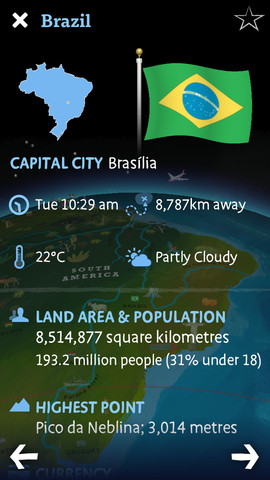
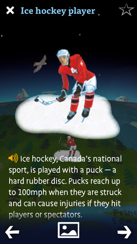
Barefoot World Atlas - Barefoot World Atlas is an educational app that allows children to explore the world on an interactive 3D globe.
The app is filled with information about the different regions and countries of the world, wildlife facts, natural landmarks, famous buildings, and more.
Barefoot World Atlas uses the power of the Wolfram|Alpha computational knowledge engine to show comprehensive info about every country in the world.
What's New in This Release:
· The Barefoot Team have been working hard this month making our puzzle pack even bigger and better. In this update you'll find not one, not two, but but three new games! Now you can test your knowledge of the animals, buildings and people you find dotted across the globe. We've even gone and added a new game to the International Soccer pack (yeah, we miss Brazil 2014 a bit too).
· But that's not all! We've managed to dust off some long-lost features and bring them out of retirement. Back by popular demand are Search and Favourites. Track down those sneaky features with the search, and mark your favourites with a star.
· As always our bug-catcher in chief has been at work with his net, travelling the globe capturing any nasty little bugs and getting them out of the way so you can have a better, more enjoyable experience.
What's New in 3.0.3:
· Added two more incredible expansion packs: INTERNATIONAL SOCCER and WORLD ART!
What's New in 3.0.2:
· Significant stability and performance improvements, in particular on iPad2, iPhone and iPod Touch
Like it? Share with your friends!
If you got an error while installing Themes, Software or Games, please, read FAQ.
Supported operating systems:
Apple iOS 10.x (iPad), Apple iOS 10.x (iPhone), Apple iOS 11.x (iPad), Apple iOS 12.x (iPad), Apple iOS 12.x (iPhone), Apple iOS 7.0 (iPad), Apple iOS 7.0 (iPhone), Apple iOS 7.0 (iPod Touch), Apple iOS 8.x (iPad), Apple iOS 8.x (iPhone), Apple iOS 8.x (iPod Touch), Apple iOS 9.x (iPad), Apple iOS 9.x (iPhone), Apple iOS 9.x (iPod Touch)
Similar Software:
Muritz National Park - GPS Map Navigator Muritz National Park - flytoMap provides complete, quick and easy to use map applications for navigation for iPhone. Continues in the tradition of offering depth of information and functionality across expected places all over the world, exploring the map you get maximum details obtaining detailed information of every object on the map
Marine: Cherbourg to Channel Islands - Solent Marine: Cherbourg to Channel Islands - Solent - Cherbourg to Channel Islands is a high quality map with detailed water navigation information and important features compressed to assure the bigger coverage.
Map contains embedded electronic nautical charts from IHO's compressed to a large coverage
Kuala Lumpur Street Offline Kuala Lumpur Street Offline - You don't need to have internet connection for this to work as the map is stored on your iPhone or iPod Touch. Ideal for saving roaming charges or having to find the local wifi to access the built-in map application
Brighton Offline Street Map Brighton Offline Street Map - You don't need to have internet connection for this to work as the map is stored on your iPhone or iPod Touch. Ideal for saving roaming charges or having to find the local wifi to access the built-in map application.
What's New in This Release:
· iOS 5 compatibility changes.
· Further bug fixes and improvements
Mumbai Street Map Offline Mumbai Street Map Offline - You don't need to have internet connection for this to work as the map is stored on your iPhone or iPod Touch. Ideal for saving roaming charges or having to find the local wifi to access the built-in map application
New York City Guide - Lonely Planet Comprehensive maps ensure you're never lost in this vast cultural playground; detailed history, culture and language chapters give you an essential entree to local life and independent, in-depth research means you'll never need to second guess
UAE Map UAE Map - This application enables you to use maps offline without internet connection. This includes maps street names detail. This will give peace of mind when traveling aboard knowing you will not be charged with roaming fee. So if you live or travel in that city, it will help you much in your life
Charleston Walking Tours and Map Charleston Walking Tours and Map - No need to hop on a tour bus or join a group; now you can explore all the best attractions on your own, at your own pace, and at a cost that is only a fraction of what you would normally pay for a guided tour
Fort Wayne Street Map Fort Wayne Street Map - Lets you find all streets, and many useful locations such as ATM's, parkings, museums, and many others. Remembers where you've been so you can find that parking spot where you left your rental car
Barefoot World Atlas Barefoot World Atlas - Barefoot World Atlas is an educational app that allows children to explore the world on an interactive 3D globe.
The app is filled with information about the different regions and countries of the world, wildlife facts, natural landmarks, famous buildings, and more

")