Platforms: iPhone, iPad, iPod Touch, Apple iPhone OS
Categories: Travel & Navigation
Upload date: 21 Jul 13
Developer: Touch Press
License: Freeware
Downloads: 57
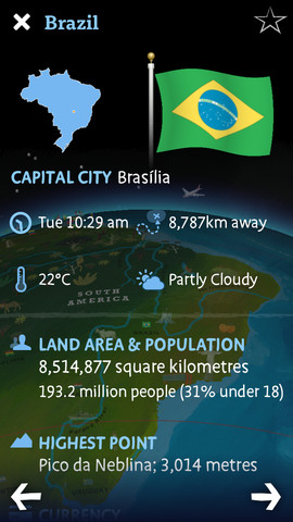
Barefoot World Atlas - Barefoot World Atlas is an educational app that allows children to explore the world on an interactive 3D globe.
The app is filled with information about the different regions and countries of the world, wildlife facts, natural landmarks, famous buildings, and more.
Barefoot World Atlas uses the power of the Wolfram|Alpha computational knowledge engine to show comprehensive info about every country in the world.
What's New in This Release:
· German localization added
· Re-engineering of the animations that has reduced the app size by 600MBs
· Minor bug fixes
Like it? Share with your friends!
If you got an error while installing Themes, Software or Games, please, read FAQ.
Supported operating systems:
Apple iOS 10.x (iPad), Apple iOS 10.x (iPhone), Apple iOS 11.x (iPad), Apple iOS 12.x (iPad), Apple iOS 12.x (iPhone), Apple iOS 5.0 (iPad), Apple iOS 5.0 (iPhone), Apple iOS 5.0 (iPod Touch), Apple iOS 6.0 (iPad), Apple iOS 6.0 (iPhone), Apple iOS 6.0 (iPod Touch), Apple iOS 7.0 (iPad), Apple iOS 7.0 (iPhone), Apple iOS 7.0 (iPod Touch), Apple iOS 8.x (iPad), Apple iOS 8.x (iPhone), Apple iOS 8.x (iPod Touch), Apple iOS 9.x (iPad), Apple iOS 9.x (iPhone), Apple iOS 9.x (iPod Touch)
Similar Software:
Los Angeles City Atlas (High Definition Zoom) * GPS Travel Companion USA Los Angeles City Atlas (High Definition Zoom) * GPS Travel Companion USA - Each map can be amplified several times.
The special customized Atlas Guide can get information such as:
flags
maps
travel information
touristic top locations
history
currencies
trivia
humor
pictures
videos
museums information
restaurant information
accommodations / hotel
San Jose Walking Tours and Map San Jose Walking Tours and Map - No need to hop on a tour bus or join a group; now you can explore all the best attractions on your own, at your own pace, and at a cost that is only a fraction of what you would normally pay for a guided tour
Yorkshire Dales National Park - GPS Map Navigator Yorkshire Dales National Park - GPS Map Navigator - FlytoMap provides complete, quick and easy to use map applications for navigation for iPhone. Continues in the tradition of offering depth of information and functionality across expected places all over the world, exploring the map you get maximum details obtaining detailed information of every object on the map
America Maps - Touch States America Maps - Touch States - Get a convenient and comprehensive collection of 50 USA state maps in your pocket today!
Now with maps of:
- North America
- Central America
- South America
View the 50 State maps easily by scrolling and zooming.
Take screen shots of any map for your personal use.
Touch States is great for school, work, leisure or anything else
Greensboro - Winston - Salem Map Offline Greensboro - Winston - Salem Map Offline - This will be perfect when you are traveling and you don't have internet connection. This Offline Maps is not a replacement of Google Maps. It is used when you don't have internet connection and want to use maps
Smart Maps - Vienna Smart Maps - Vienna - Smart Maps offers you an offline street level map, allowing you to search or navigate without an internet connection. Smart Maps will save you the money you pay for expensive data roaming charges or additional costs for local internet traffic.
· No internet connection required
Cincinnati Maps Offline Cincinnati Maps Offline - This will be perfect when you are traveling and you don't have internet connection. This Offline Maps is not a replacement of Google Maps. It is used when you don't have internet connection and want to use maps
OffMaps 2 OffMaps 2 - OffMaps 2 allows you to carry maps of the whole world with you everywhere you go.
With the app, you can search for points of interest around you, see your current location and bookmark favorite places.
Maps can be downloaded to your iOS device for offline use and are based on data from OpenStreetMap
London Master A-Z London Master A-Z - This clear and colourful high quality map covers the same area as the market leading A-Z "Master Atlas of Greater London Street Atlas". The familiar look makes this by far the easiest London iPhone map to use. The map is drawn by real cartographers with the detailed care and the human touch of emphasis and colour that A-Z are famous for
Bangor, Llangefni Street Map Bangor, Llangefni Street Map - Lets you find all streets, and many useful locations such as ATM's, parkings, museums, and many others. Remembers where you've been so you can find that parking spot where you left your rental car
Other Software by developer «Touch Press»:
Barefoot World Atlas Barefoot World Atlas - Barefoot World Atlas is an educational app that allows children to explore the world on an interactive 3D globe.
The app is filled with information about the different regions and countries of the world, wildlife facts, natural landmarks, famous buildings, and more

")


 * GPS Travel Companion USA")


