Platforms: iPhone, iPad, iPod Touch, Apple iPhone OS
Categories: Travel & Navigation
Upload date: 4 Nov 11
Developer: Visual IT
License: Commercial
Price: 2.99 $
Downloads: 21
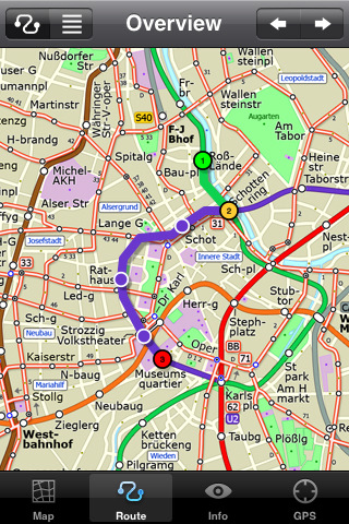
Vienna Metro by Zuti - This Zuti application contains a visually unique map of Vienna's transport systems and a superb animated journey planner to help you get around the Metro (U-Bahn), Suburban Rail (S-Bahn) and Tram (Stragenbahn). Unlike old fashioned schematic style maps this product contains a geographically accurate central area showing major streets, parks and places of interest etc, allowing the user to easily get their bearings in the city. This application is one in a worldwide series of Zuti maps from Visual IT who have been producing public transportation maps for mobile devices for many years.
MAP
The map is hand drawn by Visual IT and provides a unique geographically based view of the city with many places of interest drawn directly on the background. You can use your inbuilt GPS (can also work with iPod Touch devices) to accurately locate and track yourself within the city centre and see the nearest transportation stop and distance to it. This is the only pubic transportation route planner with this ability.
Tap on the map for location information, use the inbuilt search feature or choose from a list of locations. Places of interest, museums, hotels, parks, restaurant, shops, hospitals, streets, etc, are also included. The route planner will automatically suggest the nearest station to any place of interest you select.
NO INTERNET CONNECTION REQUIRED
The map and routing does not require an internet connection and you will not be charged data connection fees. This also means the application runs successfully underground and on an iPod Touch.
ROUTING
Does not require an internet connection and will always be available to display a clear and detailed view of the city transport systems, plus list and animate the optimum route for your journey. Provides the fastest route calculations of any mobile routing application (virtually instantaneous) using actual published journey times with the ability to select the quickest route or the route with the least changes.
Comprehensive details of your planned route are provided, including changes, directions of travel, number of stops, predicted journey times, etc. Uniquely this application gives you “direction”, “towards” and “service frequency” information (not available on any other offline journey planner) for example “Take the Red line (Southbound) towards 95th/Dan Ryan for 6 stops. Service runs every 7 minutes” which is essential when finding the correct platform and connection. Also given are alternatives for each leg of the journey.
What's New in This Release:
· Bug fix for iOS 5
· Support for retina display
· New "Measure Tool"
Like it? Share with your friends!
If you got an error while installing Themes, Software or Games, please, read FAQ.
Supported operating systems:
Apple iOS 10.x (iPad), Apple iOS 10.x (iPhone), Apple iOS 11.x (iPad), Apple iOS 12.x (iPad), Apple iOS 12.x (iPhone), Apple iOS 4.0.x (iPhone), Apple iOS 4.0.x (iPod Touch), Apple iOS 4.2.x (iPad), Apple iOS 4.2.x (iPhone), Apple iOS 4.2.x (iPod Touch), Apple iOS 4.3.x (iPad), Apple iOS 4.3.x (iPhone), Apple iOS 4.3.x (iPod Touch), Apple iOS 5.0 (iPad), Apple iOS 5.0 (iPhone), Apple iOS 5.0 (iPod Touch), Apple iOS 6.0 (iPad), Apple iOS 6.0 (iPhone), Apple iOS 6.0 (iPod Touch), Apple iOS 7.0 (iPad), Apple iOS 7.0 (iPhone), Apple iOS 7.0 (iPod Touch), Apple iOS 8.x (iPad), Apple iOS 8.x (iPhone), Apple iOS 8.x (iPod Touch), Apple iOS 9.x (iPad), Apple iOS 9.x (iPhone), Apple iOS 9.x (iPod Touch), Apple iPhone OS 3.1.x, Apple iPhone OS 3.1.x (iPod Touch), Apple iPhone OS 3.2.x (iPad)
Similar Software:
Washington Metro by Zuti Washington Metro by Zuti - The new Washington Metro 10 map makes it easy to travel in and around the city using the WMATA Metro, MARC and VME systems. Also included are the Potomac river taxi routes and the DC Circulator bus routes
Up North! Grand Traverse Up North! Grand Traverse - Experience the many faces of the Grand Traverse region with this travel application from Sutro Media - Up North! Grand Traverse.
A Grand Traverse adventure can be a lot of things to different people. For some, Grand Traverse is a vast playground, ripe with opportunities for hiking and biking, camping and fishing, swimming and paddling
iBART Live iBART Live From the makers of the acclaimed iBART, iBART Live is an intelligent transit application for Bay Area Rapid Transit. It is essential to all BART riders — from the occasional to the daily, the tourist to the commuter
London Central Bus 10 London Central Bus 10 - The new Zuti London Bus map has finally arrived, making it easy to travel by bus anywhere in central London. This clear and colourful map covers a detailed street level area of 6 miles by 4 miles and includes over 1300 bus stops and 189 bus routes
San Antonio Driving Tours This revolutionary application presents you several driving tours designed to show you the best of the city, as it comes with detailed tour route maps and powerful navigation features to guide you from one sight to the next
Thalys for iPhone Thalys for iPhone - Thalys is a useful app which makes trips to Paris, Brussels, Amsterdam and Cologne easier. Thalys replaces conventional tickets, allowing you to simply show your iPhone screen to the ticket collector on board the train
TripAdvisor for iPhone/iPad TripAdvisor for iPhone/iPad - TripAdvisor is your one stop for all your travel needs. It includes reviews and advice on hotels, restaurants, resorts, flights and more
Atlanta Maps Atlanta Maps - software that helps you download and store the travel maps and plans you need. This super-handy app lets you download publicly available maps and store them on your iPhone or iPod Touch. You can download the maps when you have fast wifi connection - and then use any time in the future without delay
Hotels by Orbitz Hotels by Orbitz - Simple, powerful, fast and fun. The free Orbitz app designed just for the iPad lets you shop and book hotels effortlessly -- on the couch or on the go. It delivers a vast selection of hotels, powerful comparison tools, and secure booking in just 3 taps. And you can do it all within the vivid, friendly interface of the iPad, from the comfort of your ..
TransitM&S Nashville TransitM&S Nashville - TransitM&S is an easy-to-use transit application that provides bus info for Nashville's MTA.
The app is designed for offline use. It is ideal for iPod Touch users. Even for iPhone users, it is designed to save money because AT&T no longer offers the unlimited data plan
Other Software by developer «Visual IT»:
Tube 2 Boston Pro (Palm OS) Tube 2 Boston Pro (Palm OS) - This map package for Tube 2 consists of a fully scrollable detailed map of the Boston metro & commuter rail system and linked street maps of central Boston.
Plan journeys on the metro system, list details of the quickest routes and see a superb animated display of your journey tracking around the system map
Tube 2 London (Palm OS) Tube 2 London (Palm OS) - This map package for Tube 2 consists of a fully scrollable detailed map of the London Underground system.
Plan journeys on the London Underground system, list details of the quickest routes and see a superb animated display of your journey tracking around the system map
Tube San Francisco Pro for Palm OS Tube San Francisco Pro for Palm OS - This map package for Tube 2 consists of a fully scrollable detailed map of the San Francisco metro & rail systems and linked high quality street maps of central San Francisco
Tube 2 Budapest (UIQ3) Tube 2 Budapest (UIQ3) - This map package for Tube 2 consists of a fully scrollable detailed map of the Budapest metro system and HEV suburban railway.
Plan journeys on this system, list details of the quickest routes and see a superb animated display of your journey tracking around the system map
Tube 2 Baltimore (Palm OS) Tube 2 Baltimore (Palm OS) - This map package for Tube 2 consists of a fully scrollable detailed map of the Baltimore metro & rail system.
Plan journeys on this system, list details of the quickest routes and see a superb animated display of your journey tracking around the system map
Rough Guides Map Barcelona Rough Guides Map Barcelona... These guides are a series of fantastic interactive maps.
Produced in conjunction with the premier travel publisher Rough Guides.
Discover and explore Barcelona using full colour interactive linked maps, in this simple to use PDA version of The Rough Guides Barcelona
Tube 2 Chicago (Palm OS) Tube 2 Chicago (Palm OS) - This map package for Tube 2 consists of a fully scrollable detailed map of the Chicago metro & commuter rail system.
It includes the rapid transport system of subway and elevated lines, in addition to the many commuter rail lines. The map also indicates how the Amtrak intercity routes intersect with the cities transport network
Tube 2 Milan (UIQ3) Tube 2 Milan (UIQ3) - This map package for Tube 2 consists of a fully scrollable detailed map of the Milan metro & rail system.
Plan journeys on this system, list details of the quickest routes and see a superb animated display of your journey tracking around the system map
Tube 2 Tokyo (UIQ) Tube 2 Tokyo (UIQ) - This map package for Tube 2 consists of a fully scrollable detailed map of the Tokyo city subway & JR rail system
Rough Guides Map San Francisco Rough Guides Map San Francisco... These guides are a series of fantastic interactive maps.
Produced in conjunction with the premier travel publisher Rough Guides.
Discover and explore San Francisco using full colour interactive linked maps, in this simple to use PDA version of The Rough Guides San Francisco

")


")
")

")
")

")
")
")
