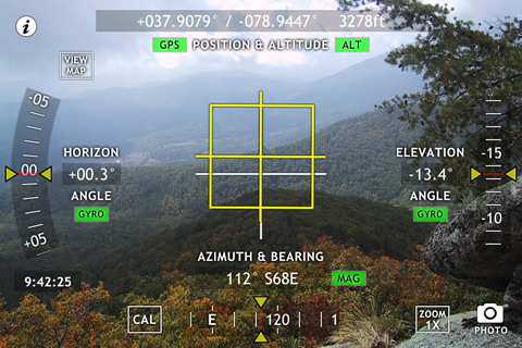
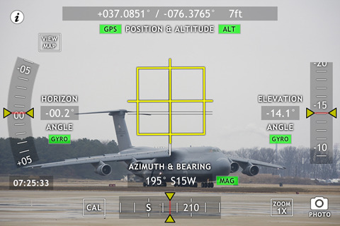
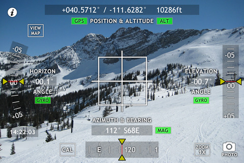
Theodolite Basic - Based on a centuries-old astronomical instrument, Theodolite Basic is a cool multi-function augmented reality app for the iPhone that serves as a compass, GPS, map, zoom camera, and two-axis inclinometer. Theodolite Basic overlays real time information about position, altitude, bearing, and horizontal/vertical inclination on the iPhone’s live camera image, like an electronic viewfinder. Uses are endless, from land surveying to navigation, and the app is great for hiking, boating, hunting, golf, sports, sightseeing, and finding your way around.
Theodolite Basic lets you take camera images and screenshots directly from the app, with 2X and 4X digital zoom options. You can choose to stamp geographical data and custom notes directly on the saved image for later reference. View your current position on the built in map view, with standard, satellite, and hybrid modes. On an iPhone 3GS and 4, bearing is updated live on the map with both fixed view and world rotation.
Be sure to check out the more powerful Theodolite Pro, which adds a zero reference mode for angles and a handy "A-B" calculator to compute height of landmarks, distance to landmarks, triangulate position, compute distance/heading between points, show relative angles between observations, and show points on the map. Theodolite Pro also provides integration with the system-wide clipboard, e-mail data export with KML, mil compass readout, optical rangefinders (including a mil-based reticle), display of percent grade, and multiple position formats including MGRS and UTM.
Note: Theodolite works on any iPhone. GPS functionality requires an iPhone 3G, 3GS, or 4. Compass functionality requires an iPhone 3GS or 4. On iPhone 4, compass and inclinometer data are augmented by the gyro, and the application uses high res artwork for the Retina Display.
What's New in This Release:
· Geo-tag metadata (position, altitude, bearing, datum, compass reference, user note) now saved in image EXIF headers when taking photos and screenshots. New icon artwork
Like it? Share with your friends!
If you got an error while installing Themes, Software or Games, please, read FAQ.
Supported operating systems:
Apple iOS 10.x (iPhone), Apple iOS 12.x (iPhone), Apple iOS 4.2.x (iPhone), Apple iOS 4.2.x (iPod Touch), Apple iOS 4.3.x (iPhone), Apple iOS 4.3.x (iPod Touch), Apple iOS 5.0 (iPhone), Apple iOS 5.0 (iPod Touch), Apple iOS 6.0 (iPhone), Apple iOS 6.0 (iPod Touch), Apple iOS 7.0 (iPhone), Apple iOS 7.0 (iPod Touch), Apple iOS 8.x (iPhone), Apple iOS 8.x (iPod Touch), Apple iOS 9.x (iPhone), Apple iOS 9.x (iPod Touch)
Similar Software:
Cuyahoga Valley National Park - GPS Map Navigator Cuyahoga Valley National Park - GPS Map Navigator - Continues in the tradition of offering depth of information and functionality across expected places all over the world, exploring the map you get maximum details obtaining detailed information of each object on the map
Navfree GPS + Street View Italy Navfree GPS + Street View Italy - Navfree is a free GPS navigation solution for iOS devices. The app uses OpenStreetMap data, created and updated by thousands of users from all over the world.
The maps are stored locally on the device, so there is no need for a data connection
Garmin Thailand Garmin Thailand - Garmin StreetPilot is a powerful GPS navigation solution for iOS devices. It comes preloaded with the latest map of Thailand.
Garmin Street offers many useful features, such as turn-by-turn directions, photo-realistic junction views, 3D buildings, exit services, speed cameras, and more
BaseCamp Mobile BaseCamp Mobile - BaseCamp Mobile is a companion app for the Garmin fenix GPS watch. It allows you to wirelessly download data from your watch to the iPhone.
Downloaded data can be used to view routes and tracks on a map. Very useful for recording and reviewing your outdoor activities
Ndrive Brasil Ndrive Brasil - This app will turn your iPhone into a turn by turn voice navigation device.
WHAT YOU ARE BUYING
You are buying a lifetime license of the latest maps. There are no monthly fees or hidden charges.
No data plan is needed to run NDrive software and even when your phone is in roaming, your GPS Navigation from NDrive will run smoothly and uninterupted
CoPilot Live Western Europe CoPilot Live Western Europe - Welcome to CoPilot Live, the multi-award winning turn-by-turn sat navigation app with digital street maps of Western Europe.
CoPilot Live is your personal travelling assistant, always ready to guide you to the door with voice directions. It can also keep you better informed with useful live information about your route
Grenadines & Grenada - GPS Map Navigator Grenadines & Grenada - GPS Map Navigator - FlytoMap provides complete, quick and easy to use map applications for navigation. Continues in the tradition of offering depth of information and functionality across expected places all over the world, exploring the map you get maximum details obtaining detailed information of every object on the map
New Caledonia - GPS Map Navigator New Caledonia - GPS Map Navigator - FlytoMap provides complete, quick and easy to use map applications for navigation. Continues in the tradition of offering depth of information and functionality across expected places all over the world, exploring the map you get maximum details obtaining detailed information of every object on the map
Albuquerque GPS Guide The only thing we do, help you to move freely as an alien, by "Offline" & "GPS"
Sygic Argentina, Chile, Uruguay: GPS Navigation Sygic Argentina, Chile, Uruguay: GPS Navigation - Sygic is a premium turn-by-turn GPS navigation application. Sygic boasts an intuitive interface: drag the map, pinch to zoom, change point of view using built-in compass and tap target square to choose action
Other Software by developer «Hunter Research and Technology»:
Theodolite Pro Based on a centuries-old astronomical instrument, Theodolite is a cool multi-function augmented reality app for the iPhone that serves as a compass, GPS, map, zoom camera, rangefinder, and two-axis inclinometer
ODAT Tracker This application tracks deals from backcountry.com's "one deal at a time" (ODAT) sites
gMeter gMeter is an application that turns the iPhone and iPod Touch into a vehicle performance computer. By using the onboard accelerometer in these devices, gMeter can measure forward and lateral g forces and use this data to compute acceleration, velocity, distance traveled, and engine power
gyroLens gyroLens - Ever have problems taking that perfect photo? Can't frame a straight shot? Need help getting a level image? Use gyroCam! This full-featured camera app has a killer new feature: it automatically levels photos in real time, while shooting
gyroCam gyroCam Ever have problems taking that perfect photo? Can't frame a straight shot? Need help getting a level image? Use gyroCam! This full-featured camera app has a killer new feature: it automatically levels photos in real time, while shooting
Flow (iPhone) Flow (iPhone) is a handy fluid dynamics app for the iPhone and iPod Touch. The software implements 1D compressible flow equations, normal and oblique shock relations, laminar and turbulent flat plate boundary layer development, standard atmosphere modeling, and the gas properties of air at sea level
Wx for iPad Wx for iPad The venerable U.S. weather app Wx is now available for iPad! Wx displays current conditions, forecasts, alerts, and radar for U.S. locations using high fidelity XML data from the U.S. National Weather Service
Theodolite Free Theodolite Free Based on a centuries-old astronomical instrument, Theodolite Free is a cool multi-function augmented reality app for the iPhone that serves as a compass, GPS, zoom scope, and two-axis inclinometer
Theodolite Based on a centuries-old astronomical instrument, Theodolite is a cool multi-function augmented reality app for the iPhone that serves as a compass, GPS, map, zoom camera, rangefinder, and two-axis inclinometer

")


")


